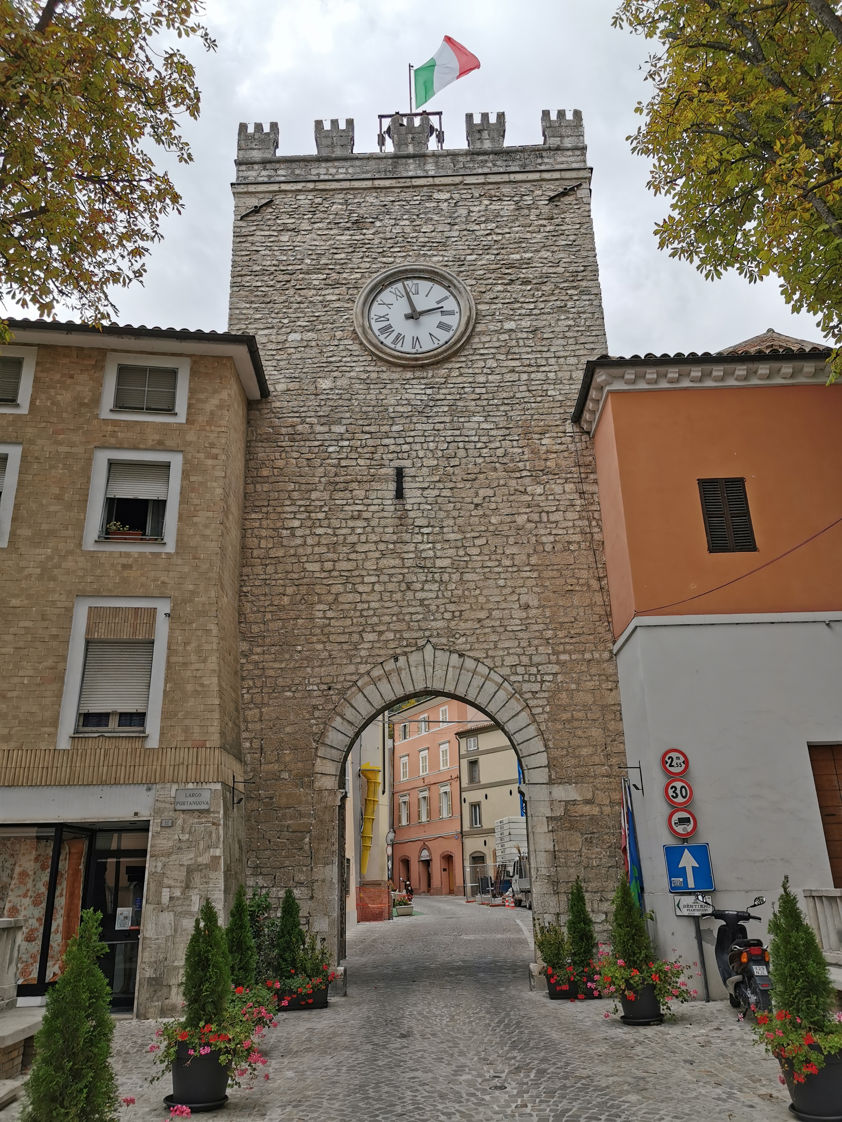
Ania and I decided to do a week-long trip by car to the south, visiting some towns in the Marche region and in the eastern part of Emilia-Romagna. After leaving Vicenza in the morning and taking the highway we drove for about 2h hours and then decided to stop on the way at a place called Bio Burg Superfood which we had seen online had also a choice of a vegan burger. Once there though we found out it was just a few vegetables inside a bun, so without an actual patty, and for the price of a normal burger. Mine was good but Ania's one plain and expensive, and after complaining about it we left rather unsatisfied. Driving further on we then decided to stop, right after crossing the border into the Marche region, in the town of Gradara. The town located on a hilltop is part of the club of the most beautiful villages in Italy and is famous for its beautifully preserved medieval castle and walls surrounding the tiny old town. We found a parking spot right below the walls and from there continued on foot. We entered through the southern and main gate, topped by the nice clock tower, and continued uphill along the main street. At the end of it at the top was the castle, originally dating to the 12th century and expanded in the following two centuries. From the top, which stands at 141m above sea level, the view dominates the surrounding hills and the Adriatic sea to the north. Unfortunately, we couldn't visit the interior as on Mondays the castle was only opening in the morning and we had just arrived after closing time. We then decided to walk through the rest of the old town, passing by the impressive walls, dating to the 13th and 14th centuries, and surrounding the town completely for a total of about 800m. We then headed out through a small opening in the walls and then completed a round of the perimeter of the walls until we reached the car once again. We drove to the nearby city of Pesaro where we then found parking and visited the city center on foot. We first passed by the church of San Giovanni Battista, with a renaissance facade, which was closed, and then past the Museo Nazionale Rossini, hosted inside Palazzo Montani Antaldi, which details the life of the music composer Gioachino Rossini, born in Pesaro in 1792. Continuing on we then reached the central square, Piazza del Popolo, with at its center the fountain built in 1593 and known as the Pupilla di Pesaro. On the northwestern side of the square is the Palazzo Ducale, a renaissance palace from the mid-15th century, built by Alessandro Sforza as the main seat of power and now functioning as the office of the prefecture. We could only see it from the outside so we then continued on through the city center and then passed in front of the Casa Rossini, where the famous composer was born. Not far ahead we then reached the Cathedral which unfortunately was closed so we could only see the incomplete facade from the outside. We then continued onwards and walked around the large structure of the Rocca Costanza, the 15th-century squared fortress which was then used as a prison until 1989 and is now used for cultural events. From there a short walk then led us to reach the nearby beach which we walked along for a bit before heading back to the city center. After one last stroll, we then reached the car and from there drove to the nearby city of Fano, also set along the Adriatic coast. We parked the car in front of the b&b we would sleep in that night, right outside the city center, and then headed in that direction on foot. The first main monument we came upon was the Basilica of San Paterniano, built in the 16th century and featuring a nice cloister. Then a little further we passed by the small nice neogothic structure of the church of Sant'Anotnio Abate, before reaching the central square, Piazza XX Settembre. It featured a nice fountain from 1593 at its center topped by the goddess fortune, and on the northwestern side, the Palazzo del Podestà once the seat of the city's governor but later turned into the city's main theatre, the Teatro della Fortuna. Its facade is the only surviving part of the ancient palace while its clock tower is a post-war reconstruction after it was destroyed together with most other towers in the city, during WWII. Walking further we then passed by the church of San Francesco, or what was left of it, as its suffered major damage during an earthquake in 1930 when its rooftop fell. Nowadays it is still roofless but it's quite a sight to see with its gothic and baroque styles mixing together. Not too far on we then passed by the beautiful Palazzo Malatestiano, a renaissance palace built by the Malatesta family which ruled over the city between the 13th and 15th centuries. As we continued on we then walked past the Cathedral, which unfortunately was closed so we could only see the nice romanesque facade from the exterior. A few steps from it though we then admired the city's main monument, the beautiful Arch of Augustus, an ancient Roman city gate in the form of a triumphal arch with three vaults that served as the entrance to the city by the via Flaminia. Though mostly perfectly preserved it lost its upper part in 1463 when Federico da Montefeltro besieged the city in order to expel its lord Sigismondo Pandolfo and take control of it. Right in front of the roman gate was another city gate, this time a few centuries younger, dating to the 15th century, the Porta Maggiore. It served as the medieval entrance to the city and is now part of the walls that closed most of Fano on its south and western sides. In fact, the ancient Roman walls of the city remained largely intact and were used or sometimes replaced by medieval ones later on. We followed these walls and eventually reached the northern end where the Rocca Malatestiana is set. This fortress was erected during the 15th century by the ruling Malatesta family, to protect the city facing the sea. In fact, from there a short walk brought us to the beach where we decided to spend some time relaxing with the last rays of the day. The water was crystal clear and looked really clean and calm and so I decided to take a swim. After the break, we then headed back to the city, and after another stroll through the old town decided to look for a place to have dinner. We ended up choosing a place called Ambrosia which had an interesting menu that week, proposing North African dishes, which were really tasty. Once we had eaten dinner we then had another stroll through town, at night, giving it a different hue, and passing once more by the beautiful Arch of Augustus. Finally, we then headed to our b&b where we eventually checked in, had a shower, and went to bed early.
The following morning we woke up really early as I wished to leave as soon as possible to get to the beach of Sirolo. Before leaving the owner of the b&b Villa Sofia, had given us a voucher with which we were able to get breakfast from the bar nearby. After that, we then drove southeast for about one hour until we reached the seaside town of Sirolo. We arrived early so were able to find a spot in the free parking lot, and from there continued on foot. We first stopped at the small supermarket in town where we bought some food to take with us down to the beach and eat later for lunch, and two inflatable airbeds to use on the water. From there we then walked down the cliff and reached the beautiful beach, Spiaggia San Michele, just to the north of the old town. Luckily there were barely any people there, as it was still early, but it did eventually fill up later in the day despite it being a weekday. We continued on along the shore, reaching then the northern end right below the cliffs where the beach changes name as is known as Sassi Neri. Here we found a spot below some hanging rocks and left our stuff and food in the shade. We saw that there were kayaks and canoes for rent, but they were rather expensive at 15 euros an hour, so we decided to buy the inflatable airbeds instead for 5 euros and with that attempt to reach the nearby beach of Le Due Sorelle. In fact, this was only accessible by boat, as it is set below the cliffside, and the trail to eat from above has been closed for years due to the risk of rockslides and deaths which had occurred in the past. So after inflating the airbeds we started walking on the rocky coast as far as we could go as that would mean less time pushing through the water. Once we couldn't continue further on foot, we got on the water, laid on the floats, and paddled our way toward the beach. In about an hour, we reached it, and despite the rather early hour found it already with several people, most of them had come by boat and some with their canoes and kayaks; we were probably the only ones who had chosen our alternative method of transport. We decided to lay on the small stones beach and enjoy a bit of a break basking in the sun and swimming in the incredible crystal clear waters. After a bit there we then decided to start heading back as we still had our lunch waiting for us on the other beach. We then got back on the airbeds and paddle our way back to the beach; Ania was tired so she grabbed hold of my feet while I paddled us back to the start. Once there we then had our lunch and spend the rest of the afternoon laying in the sun and taking some occasional swims. Then, as the beach faces the east and is surrounded by the cliffs of the Conero Riviera the sun was almost gone by 4pm so we then decided to head back up and into the town of Sirolo. We first reached the car and changed into our clothes and then walked through the pretty old town which I had visited back in 2020 when I had walked through it during my pilgrimage to Florence. After admiring the beautiful view of the coast from the town's lovely panoramic terrace and strolling around for a little while we decided to head to the nearby town of Numana on foot to visit it as well. Here we then decided to look for a place to have dinner and eventually chose the Pizzeria Da Luca where we had a tasty pizza and some olive all'ascolana as appetizers. After dinner, we then walked back to the car and decided to look for a place to set up our tent: in fact, I had convinced Ania, to try to camp for a night or two during our week, and that night, close to the sea, had seemed the best night to try that. We drove a few hundred meters out of town to reach the nearby cemetery where a large parking spot, used during the day for the beachgoers, was set. It was empty so we parked the car and then took the tent a bit to the edge of it, in the darkest spot, and set it up. We then laid our air mattresses inside with the sleeping bags and tried to fall asleep. After a bit though I immediately woke up as I heard some strange sounds. There were in fact some wild boars nearby I could hear their grunts and squeals right outside the tent. I woke up Ania to tell her but she seemed not bothered by it so we eventually fell asleep again.
In the morning through, rather early, the garbage collector truck had decided to cover the area where our tent was and woke us with the headlights and engine sound. We then tried sleeping a little longer but were a little afraid we might get fined, as we were very close to the nature park and were not sure if we were allowed to camp there. So eventually, due to that and to the fact that at 6am the sun was already rising, we decided to get, disassemble the tent, and put everything back in the car. Then from there, I decided to show Ania a really cool spot I had seen on my hike through the area two years before. We followed the trail and in just less than one hour uphill through the Conero Regional Park, reached the beautiful panoramic point of the Belvedere Sud from where we had a spectacular view of the coast and of the Due Sorelle beach right below. After enjoying the panorama we walked back the way we came and decided to spend a few more hours down at the beach of San Michele. This time we decided to stay closer to the town and use our air mattress just to lay on instead of paddle somewhere else. It was still rather sunny and warm despite the few clouds coming in so I picked up some branches scattered around, set them in a hut shape, and covered them with my breach towel to provide us with some shade. We then spend some more time there, eating the lunch we had bought again at the supermarket on the way down. After that we decided it was time to head on, so we reached the car, and then drove in the direction of Loreto, which I had seen before but wished Ania would see it too. We found a spot in the public parking right outside the walls and from there continued on foot through the small old town, characterized by the beautiful Renaissance Basilica della Santa Casa, known for enshrining the Madonna and Child image of “Our Lady of Loreto”. Nearby we then also visited the Polish War Cemetery, one of four found in Italy. It was rather sad but really nice as it had a beautiful view of the sea and of Mount Conero from where we had just come. After visiting the rest of town we headed back to the car and then drove to the nearby town of Castelfidardo, set at about 212m above sea level, on a hilltop, like most of the towns we would see in the coming days. We reached it in about ten minute drive and managed to find parking right outside the medieval walls. Continuing on foot we then entered the old town by passing through the Porta Vittoria, a baroque city gate built in 1775. Walking through the old town we reached the central main square where the nice Palazzo Comunale, dating to the 16th century, and the main church, the Collegiata di Santo Stefano, are set. The latter was rebuilt during the 18th century in a Neoclassical style but still featured a nice 15th-century crypt. Strolling a little more through the rest of town we then got back in the car, and after another short drive, of about 15 minutes, reached the town of Osimo. After a bit of driving around, we managed to find a parking spot and then continuing on foot reached the funicular railway which took us up to the old town. We then came out in the central main square, the Piazza del Comune, where the imposing Palazzo Comunale is set. It is composed of a mannerist main building and the civic tower from the 13th century. From the square, we then walked westwards and reached the Cathedral, a beautiful example of a mix of romanesque and gothic. The entrance was through the baptistery, a beautiful separated part of the buildings with baroque frescoes and an incredible bronze baptismal font from 1629. Then we entered the cathedral proper, the interior of which was rather somber but featured a nice crypt from the 12th century. The crypt held different altars from ancient times such as that of the martyrs Fiorenzo, Sisinio, Dioclezio e Massimo preserved in a 4th-century ancient Roman sarcophagus, and that of San Benvenuto featuring a sarcophagus from the 5th century and the upper part from the 13th century. After the visit to the church, we then continued our walk through the city center and came upon another church, the Basilica of San Giuseppe da Copertino, featuring the original gothic exterior and a baroque interior from the 18th century. The interior features a crypt where the body of the saint, Giuseppe da Copertino, is held, and a beautiful painting depicting the Madonna with Child and Saints by Antonio Solaro from 1503. Continuing on our walk we then passed by some nice palaces including the imposing 17th century Palazzo Campana and then reached once again the Piazza del Comune. Concluding the visit to the town of Osimo we then headed back downhill to the car and drove to the nearby city of Jesi where we would be spending the night. We reached the accommodation, a nice rental apartment in the city center, and after parking the car right outside the door, checked in with the friendly owner, Nicole. We were a bit tired due to the early rise so we decided to stay in the apartment, have dinner there and go to bed early.
The morning after, I woke up early and decided to visit the old town of Jesi letting Ania rest a little longer. I left the apartment and after a short walk passed through the Porta Garibaldi, one of the city gates, to enter the old town. Jesi in fact holds a perfectly preserved medieval wall that encircles the whole city center for about 1,5km and is considered one of the best in the region. After entering the old town I came to the central main square, Piazza Federico II, surrounded by elegant palaces, the 18th-century church of San Floriano with its romanesque bell tower, and the Cathedral which I then visited. Originally built between the 13th and 14th it was completely remade in 1741 in a Baroque style but still features inside a beautiful pair of marble lions stops once part of the portal of the church. After the visit to the Duomo, I then continued on and reached another square, the Piazza Colucci, where the Palazzo Della Signoria and the Palazzo Colucci, which gave its name to the square, are set. The former is a beautiful renaissance palace once where the governor of the city used to reside and now holds the city's library, while the latter is an 18th-century baroque palace belonging to the Colocci family. Walking further I then passed through yet another square, the Piazza della Repubblica, closed on one side by the town hall, on another by the church of the Adorazione, and on the last side by the 18th-century theatre, Teatro Pergolesi. At the center of the square now stands a monumental fountain-obelisk from 1844 which between 1949 and 2021 used to stand on the Piazza Federico II but was then moved to this square for which it was originally intended. Nearby the square I then entered and visited the church of San Giovanni Battista, a typical baroque building with a nice stuccoed interior. From there I then walked along the straight main street, Corso Matteotti, which runs along the baroque and neoclassical part of town and was formed after its expansion in the 18th and 19th centuries. Along the way, I visited the Sanctuary of the Madonna delle Grazie, a nice late baroque church, and in front of it the church of San Niccolò, the oldest building in the city, dating to the 12th century. It was unfortunately closed so I continued on along the main street and eventually reached the western end of the old town where the imposing Arco Clementino, a late baroque triumphal arch from 1734, is set. I then walked back taking a different way and eventually came back to the older part of town. Here I decided to walk along the medieval walls but still kept inside the old town. On the way, I visited another late baroque church, that of San Pietro, and then walked for a short part along the ramparts. From there I had a commanding view of the northeastern part of the walls which are the most fortified of the whole complex with high ramparts and turrets every few meters. I then walked the rest of the way and finally reached the accommodation once more, still being rather early as it wasn't even 8:30am yet. Once Ania and I were ready we then got in the car and drove off to the next town, Cingoli. Part of the club of the most beautiful villages in Italy, like all others it is set on a hilltop, the Monte Circe, but at a quite high altitude, 631m above sea level. After reaching it, we parked the car right outside the town walls and then continued on foot. At first, we passed by the church of San Francesco which was closed, then we walked up the main street, Corso Garibaldi, and reached the main square, Piazza Vittorio Emanuele. Here was on one side the nice Renaissance Palazzo Comunale featuring the town's clock tower and on the other the Cathedral, which was unfortunately closed. Continuing on our walk through town we then came across a nice balcony that provided a beautiful viewpoint of the landscape surrounding Cingoli. In fact, the town is known as the "balcony of the Marche region" due to its high altitude and the 360 degrees view one can admire from there. Despite the bad weather and clouds, we were still able to see the Monte Conero far in the distance. After admiring the view it was time to head back to the car, and after a short drive through the hilly territory reached the next town, Treia. Also part of the club of the most beautiful villages in Italy, like others it sits on a hilltop surrounded by the typical hilly landscape. We parked the car outside the city walls and then entered through the northern medieval city gate, Porta Vallesacco. From there walked behind the Cathedral and tried entering it but found it closed. I noticed a pattern, in most of the towns we were visiting the churches seemed to be often closed and I finally discovered later this was because most of them were still not visitable since the 2016 earthquake which had hit central Italy. We then continued along the town's main street, Corso Italia Libera, and reached the central Piazza della Repubblica where the nice Renaissance Palazzo Comunale was located. On the southern side of the square, we then managed to visit the church of San Filippo which was open. After the visit we continued on along the main street, cutting the town right through from north to south until we reached the southern end of the old town where the Torre dell'Onglavina, a medieval tower part of the town's walls, is set. From there we then decided to walk around the perimeter of the walls admiring the town from a different perspective and then reached the car once again. After driving for a short while we then reached the third town of the day, San Severino Marche. We found a parking spot and then walked through its really pretty city center. We first passed by the church of Sant'Agostino, known as the Duomo Nuovo, or New Cathedral, which replaced the Duomo Vecchio. Unfortunately, it was closed, so we continued on but admired its nice Romanesque bell tower featuring a clock. After a bit of walking admiring the nice architecture, we then reached the western end of town where one of the city gates, Porta Romana, is located. Nearby we then visited the Basilica of San Lorenzo in Doliolo, the oldest in San Severino Marche, most probably originally dating to the 6th century. It now features a mostly 14th-century aspect, when it was restructured, with an impressive gothic bell tower and a rather empty interior. Worth visiting though was its 6th-century crypt with frescoes depicting the Stories of Saint Andrew from the beginning of the 15th century. After visiting the church we then followed a road leading up the hill that dominates the old town, known as the Monte Nero. The way up was quite steep and tough but worth it as on the top, there were many interesting monuments and a large part of the medieval walls still standing. In fact, alongside many convents and churches from the Gothic period, such as the Monasteries of Santa Chiara and Santa Caterina, there was also the aforementioned Duomo Vecchio, a beautiful romanesque gothic church now turned into a museum, and the Torre degli Smelducci, a 40m high 13th-century tower. After admiring the architecture and the view from the top, we then descended back through the old town and passed by the nice 19th-century clock tower which closed to the east the large and impressive central square, Piazza del Popolo. Unusually shaped like a spindle, it is sided by elegant palaces and arcades and is 224 meters long and 55 meters wide. Once there we decided to head back to the car and drive on to our next stop, the small town of Matelica. We parked the car and then continued on foot through the city center, looking for a place to have lunch. We picked a cafe, Cherie Caffe, where we had a so-so meal. After that, we then did our tour of the town passing by the main monuments, such as the Cathedral which was closed, and then through the central square, Piazza Enrico Mattei, with at its center the nice 16th-century fountain, and around it the nice Palazzo del Governo with the romanesque clock tower and the 16th-century market loggia next to it, then the Palazzo Comunale, the church of the Suffragio and the Palazzo Ottoni. After the round of the old town, we then got back to the car and after a five-minute drive reached the nearby town of Esanatoglia. Located at the foothills of the mountains, at about 495m above sea level, this small town is part of the club of the most beautiful villages in Italy. We parked the car right outside the old town and then headed in on foot by walking under the pretty medieval city gate, Porta Sant'Andrea, featuring a clock tower. We then walked along the main street Corso Vittorio Emanuele admiring the nice architecture of perched rock houses, until we reached the highest point in town where the church of Sant'Anatolia is located, which also gave its name to the town. The church was closed so we continued on walking through the maze of alleyways that dotted the city center and gave it the typical look of stone architecture towns of central Italy. Once we had walked around the whole area we decided to head back in the car and from there drive onwards to reach the last small town of the day, Cerreto d'Esi. Here again, we parked the car outside the old town, which in this case is a well-preserved medieval grid plan surrounded by walls. The southern and main entrance to the town was marked by the beautiful medieval tower known as the Torre di Belisario, 25m and slightly leaning, the nice set of houses built on the walls and forming a picturesque and formidable bulwark, and the Porta Giustinianea, the city gate which we walked under to enter the old town proper. We walked around the nice orderly streets with the typical low and rather unappealing houses and past the main church, the Collegiata di Santa Maria Assunta which was closed. Then we stopped at the Gelateria Miss Pistacchio where we got really tasty ice cream. Once back in the car, we then finally drove to the nearby city of Fabriano, where we had decided to spend the night. We reached our accommodation, the B&B Vetralla, located a bit further out of the city center. We checked in, showered, and then decided to head into town to visit it a little before finding a place for dinner. We parked in the large parking lot to the south of the city and then continued on foot. Our first stop was the Cathedral which was originally a Romanesque building but was reconstructed in its current Baroque style at the beginning of the 17th century. In front of the cathedral, on the other side of the little square, Piazza Papa Giovanni Paolo, was the Ospedale di Santa Maria del Buon Gesù, a medieval hospital in a gothic building with a nice loggia now holding the city's art museum. Continuing then on through the southwestern part of the city we passed by the large church of San Benedetto, which was closed, and then by the gothic church of San Domenico, whose convent now holds the Paper and Watermark Museum of the city. Fabriano is in fact known for its paper-making tradition, documented since the 12th century, and which made the city thrive and grow during the middle ages and beyond, still up to this day. The museum was already closed, as it was just past 6pm so we decided to continue on our walk through the city. We then reached the central and main square, Piazza del Comune, with at its center the beautiful fountain known as the Sturinalto, from 1285, which is considered one of the most beautiful medieval fountains ever and based on the one in Perugia. All around the square were the most important civil buildings of the city, including the Palazzo del Comune, dating to the 14th century but rebuilt in the 17th century, the Teatro Gentile da Fabriano, a neoclassical theatre from 1884, the 14th-century gothic loggia known as the Loggiato di San Francesco, the 18th century Bishop's Palace with to its side the Civic Tower rebuilt after it collapsed in 1542, and finally the beautiful Palazzo del Podestà. It is one of the best examples of gothic civic buildings of the region and was erected in 1255 and served as the seat of the city's governors. It features a large arch underneath still featuring large traces of medieval frescoes, and a street passes right under it. From the square we then continued on to visit the rest of the city, its northern part, passing by several churches all of which were unfortunately closed. We passed by the church of the Santi Biagio e Romualdo with its baroque facade, the 18th-century church of Sant'Onofrio, and the late 13th-century gothic church of Sant'Agostino now turned into the city's hospital. We then passed a nice area close to the Giano river which runs through the city that was once probably used to feed all those important paper mills of the town. We then reached another church, that of San Nicolò, which was open and featured an impressive baroque facade from 1630 with a loggia at the top, and a simple yet elegant interior. From the church, we then headed back to the main square and admired once more the picturesque setting of all those different buildings creating a wonderful scene. After walking around a bit more we decided to look for a place for dinner, we ended up choosing a restaurant called Nonna Rina, where I had some crostini with chicory and ham, and tortelli filled with guinea fowl in a pecorino cheese sauce, while Ania had pea soup with mushrooms and gnocchi with tomatoes and eggplant. After dinner, we had a last stroll through town admiring the city by night, and then headed back to the car and to our accommodation for the night.
The next morning we got up at a decent hour and after a simple breakfast for me, we drove through the city and stopped at the supermarket to get some breakfast for Ania and some lunch for us to eat later. We then left the city and after a short drive northwards reached the start of a gorge that cuts through the mountains part of the Gola della Rossa and Frasassi Regional Natural Park. Here we parked the car at a small parking lot along the road and then headed up along a trail that, through the forest, took us eventually to an amazing location where the Valadier Temple is located. This Neoclassical octagonal temple commissioned in 1828 by Pope Leo XII was built by the architect Giuseppe Valadier in an incredible and unusual location. In fact, it was built inside a cave high up on a ledge overlooking the valley. The view of it was rather amazing and we circled it and entered deeper into the cave to admire it from a different perspective. Nearby, still on the same ledge but next to a smaller cave, was the small Hermitage of Santa Maria Infra Saxa. This one was much older, having been built around the 11th century, and partly inside the rock face of the mountain. After visiting the area and admiring the view we then decided to head back down the trail and reach the car once more. Then we drove shortly on through the gorge below and reached the small town of San Vittore alle Chiuse. Here we parked the car and then walked through the medieval core with the stone bridge, over the Sentino river, and the San Vittore alle Chiuse Abbey. The latter is an 11th-century medieval abbey, one of the best examples of Romanesque architecture in the region. We visited its interior which was small and empty but had a really nice spiritual aura, typical of Romanesque buildings. After the visit to the church, we then headed to the ticket office of the Frassassi Caves where we bought tickets for the upcoming 12pm visit. We then waited for the bus which then took us to the nearby entrance to the caves. Here we joined an English tour as it meant fewer people would be part of the group and so much better for the visit. Unfortunately, as expected the level of English of the guide was not so great, but still, we appreciated the effort. The visit to the karst caves took around 1h 30 and took us through several parts and chambers which make up the part that can be visited. The caves were discovered in 1971 when a group of speleologists accidentally came upon a small opening in the rock and ended up discovering the huge chamber now known as the Abisso Abyss, a huge cavity that has an extension of 180 x 120 m and a height of 200 m; it is so large, that the Cathedral of Milan could be easily contained without problems. That chamber was the first one which is now seen by tourists coming in; from there following the path, we were then led through a series of nice smaller chambers filled with impressive stalagmites and stalactites. After the visit to the caves, we then headed back to our car and decided to continue our journey by driving on to reach the town of Arcevia. Here we parked the car outside of the city center and then visited the old town on foot. We walked along the main street, Corso Giuseppe Mazzini, passing by the Palazzo Comunale, the gothic 13th-century town hall with the 36m high civic tower. Walking on we then passed by the main church, the Collegiata di San Medardo, which was closed and reached then the northern end of the old town, where a terrace built on the natural rock on which the town stands, provided a beautiful view of the surrounding landscape consisting of gently rolling hills down below. Turning around and walking back we passed by the church of Santa Maria with its 15-century bell tower, also closed. After reaching the car, we got it and then drove on to the next town, Sassoferrato. Part of the club, the most beautiful villages in Italy, it features an old town divided into two parts, an upper town on a hilltop and a lower part on flat land next to the river. We first decided to visit the upper town, and after parking the car in front of the church of San Francesco, decided to visit start by visiting it. A 13th-century romanesque and gothic church with a racer simple but nice interior, featuring a beautiful 14th-century painted crucifix. From there we continued on along the main street, passing by the typical picturesque stone architecture. We reached the central square, Piazza Matteotti, where the town hall is located, and a short walk away then reached the Rocca di Albornoz. This 14th-century castle, of which only the central tower keep and surrounding walls remain, dominates the highest point in town. Continuing on we reached the nearby collegiate church of San Pietro, once probably dating to the same period as the castle, but then reconstructed during the 18th century. The interior featured some nice side chapels with decorated marble and paintings. From there we then headed back to reach the car and drove to the lower part of town where we visited the small waterfall and old watermills right in front of the church of Santa Maria del Ponte del Piano which was closed. Shortly after we then left the town and after a rather long drive, through narrow gorges and sometimes even too narrow two-way streets, reached the city of Gubbio in Umbria. I decided to head and sleep there even though I had been the year before as I wished Ania to see it as well. After checking in our accommodation. Happy House, we then decided to take a stroll through town, passing by the major monuments and through the beautiful medieval streets with the typical picturesque stone architecture. It started raining but luckily stopped shortly after; we then reached the Funivia del Colle Eletto, where we took the exciting gondola ride consisting of a small cage-like dangling structure that took us up to the top of the Monte Igino, where the Basilica of Sant'Ubaldo is located. From the 532m of the start, we were now at 803m and had a beautiful view of the town below and the surrounding landscape with plains, hills, and low mountains. Once up there the sun came out and we stayed for a bit admiring the view. We then decided to walk back down to town, by taking the path which winds its way in a zigzag down the mountainside. Once down, we reached the central square, Piazza Grande, where the beautiful medieval Palazzo dei Consoli is located, just in time to admire the sunset. We then decided to look for a place to have dinner but weren't sure after checking out several places; eventually, though, we noticed a large group of people gathered in front of what seemed like an enoteca, a wine shop. We headed there and found out a new place was opening called Antica Osteria and were having their new opening refreshment. It consisted of pasta dishes, porchetta sandwiches, mini pizzas, and meant other finger foods all of which were accompanied by free wine. We decided to join in and were quite surprised to see a lot of food and drinks given at an opening refreshment. We eventually basically had our dinner there and were really happy to have come across the place. After having our fill it was time for us to head back to the accommodation and to bed.
The next day, after a decent rise, we got in the car and drove leaving Gubbio behind and heading back to the Marche region. We reached the town of Cagli and after finding a parking spot continued on foot. Our first stop in town was the church of San Domenico, featuring a mostly gothic aspect, and the beautiful Tiranni chapel inside which holds a cycle of 15th-century frescoes depicting the Resurrection and the Holy Conversation by Giovanni Santi. After the visit to the church, we then continued on through town and visited then the Cathedral. Built in a Baroque style during the 17th century it featured a rather simple interior and a nice bell tower. Right in front of it we then passed through the main square, Piazza Matteotti, dominated by the austere medieval structure of the Palazzo Pubblico which took its current form during the 15th century. Continuing on we then passed by and quickly visited the small church of San Giuseppe, with a beautiful Mannerist interior from 1635 filled with stuccoes and paintings. Not far from the church we then reached the southern end of the old town where the nice tower from 1481 is located, part of a defensive system that covered part of the nearby hill that included the castle as well. Walking further we then passed by the gothic structure of the church of San Francesco, where a wedding was just beginning, so we continued on and visited the next church, that of Sant'Angelo Minore. It featured a 16th-century renaissance facade with a loggia and a simple interior baroque interior with a really nice early 16th-century painting by Timoteo Viti depicting the Noli me tangere. After reaching the car we then got on and a short drive later reached the San Vincenzo al Furlo Abbey. One of the most important in the area and of the region, this 10th-century Romanesque building features a very simple and empty interior typical of the period and architectural style. As is also the case with other similar buildings, the chancel is raised, with a narrow central staircase standing above a nice small crypt, which in this case is not underground but at ground level. A few hundred meters further we then found a parking spot at the entrance of the famous Gola del Furlo, a gorge formed by the erosive force of the Candigliano river. Set between two tall mountains, the Pietralata and Paganuccio, respectively 889 and 976 meters high, it was also very important in ancient times as this is where the ancient Roman road Via Flaminia, connecting Rome to Rimini, used to pass. During the time of our visit the road, which is normally quite trafficked was closed to cars as there had been often risks of landslides, thus only pedestrians and bicycles could pass, but only up to about three-quarters of the gorge. We decided to walk it and enjoyed the beautiful view of the blue water running alongside the road and the high mountain faces on either side. The place was really magical and I thought it would be really great to come back again and walk the trails which run on top of the mountainsides which surely grant a beautiful view of the gorge from above. As we walked the whole way up to the point where we could go no further and then back, some clouds started appearing, but luckily, as we then headed back to the car we noticed they were mostly concentrated in and around the gorge. Close to where we had parked we found a nice spot along the river and decided to enjoy the lunch which we had brought with us. Then back on the road we then drove on to reach the town of Fermignano. Here we parked the car and then walked on foot through the old town, encountering first the main monument, the beautiful roman bridge of Fermignano. Said to be dating from the ancient Roman period it was then heavily modified during the 14th century when it took its current form. It consists of a three-arched bridge 40m in length and is guarded by a picturesque tower 24m in height and dating to the 14th century as well. Next to the tower, where the Metauro river creates two small waterfalls was a paper mill dating to the middle ages, which during the 19th century was turned into a woolen mill. After walking over the main monument we then toured the small old town passing by the small main church, of Santa Veneranda, which was closed and ending on the other end where the Piazza Garibaldi is set. From there we then headed back to the car and then drove to the nearby small yet famous city of Urbino. Here we only found a spot at the paid parking lot on the southern end of the town, the Parcheggio Mercatale, but at least it was simple to enter and really close to town. In fact, we then walked up a circular staircase built inside one of the bastions which dot the Renaissance walls which completely surround the city, and from there entered the old town proper. We ended up right below the famous Palazzo Ducale, with its imposing and picturesque back facade, which we would then visit later. From there we then followed a long street and ended up in one of the main squares, Piazza della Repubblica. There were around its perimeter, the 19th century Palazzo Nuovo Albani and the 18th century Palazzo del Collegio Raffaello. Right next to the latter was the church of San Francesco, originally built during the 13th century, but later modified, particularly in its interior, in 1742 by the architect Luigi Vanvitelli. From the church we then followed a street heading uphill, called Via Raffaello in honor of the famous painter Raffaello Sanzio, In fact, not far up along the same street we came across the Casa Santi, a 14th-century townhouse where, in 1460, the painter and poet Giovanni Santi, used to live, and where, in 1483 Raphael was born. Just next to the house of the famous artist, we found an ice cream shop, Gelateria Raffaella, where we decided to treat ourselves to tasty ice cream. We then continued along a side street still heading slightly upwards, passing by the beautiful fountain from 1729, Fontana di Papa Benedetto XIII, and reached the northern end of town where one of the city gates, Porta Santa Lucia, was set. We then turned around and headed back down the way we came and passed once again through Piazza della Repubblica and reaching then the focal point of the city. Here we first visited the Cathedral, built over a pre-existing structure between the 18th and 19th centuries by the architect Giuseppe Valadier in a Neoclassical style and with a rather simple interior. Its facade reminded me a lot of the renaissance churches designed by Palladio and used as inspiration for many others in Veneto. Next to the Cathedral we then passed in front of the Ducal Palace and the church of San Domenico which we visited, originally built during the 14th century in a Gothic style but later modified in 1729. It kept its original exterior and a beautiful Renaissance portal, the first of its kind in the city, with a lunette by Luca della Robbia from 1450. but now features a rather plain late baroque interior. In front of the church, we then admired a beautiful obelisk, one of the twelve original Egyptian obelisks in Italy. Formed by four blocks on top of each other and with a bronze cross on the top, it dates back to the 6th century BC. It arrived in Urbino in 1737, brought by Annibale Albani, a cardinal related to Pope Clement XI. Continuing on we walked past the monastery of Santa Caterina and the church of San Giuseppe both of which were closed and made a round circle back to where the Cathedral and Palazzo Ducale were located. We finally entered the latter to visit the huge building and the museum contained inside the Galleria Nazionale delle Marche. The Ducal Palace, listed as UNESCO World Heritage Site since 1998, is one of the most interesting architectural and artistic examples of the entire Italian Renaissance. It was built for Duke Federico da Montefeltro around the mid-fifteenth century after becoming lord of Urbino in 1444 following a life as a mercenary captain which made him one of the most successful of the Italian Renaissance. He was a renowned intellectual humanist and civil leader and used the enormous earnings derived from his military career to maintain a splendid court, even setting up one of the most famous libraries of the time and strengthening the military defenses of the state with the construction and the restructuring of fortresses and castles. For this, he is remembered as one of the main patrons of the Italian Renaissance and is defined as "the light of Italy". After paying for the entry ticket, we first walked through the nice courtyard typical of the Renaissance with the elegant portico and arches. Heading inside the building proper we started our tour at the oldest part of the Ducal Palace, where the Appartamento Della Jole was set, built in 1445. Here were a a series of rooms, some with decorated fireplaces, walls with partly surviving frescoes, and in each some medieval objects and paintings belonging to the National Museum. One particularly nice thing was the 15th-century alcove bed used by Federico da Montefeltro before he even became duke. Up next were the Appartamento dei Melaranci and the Appartamento degli Ospiti, which held rooms that were once used by guests of the palace. Here were mainly gothic and early renaissance paintings from artists of central Italy, specifically of the area around Urbino and the Marche region in general. After that, we entered the core of the complex. where the Appartamento del Duca and the Sale di rappresentanza were set. These rooms were the heart of the ducal palace and court life and in fact, now hold the most important of the museum's pieces, such as the Madonna di Senigallia of Piero della Francesca and the Città ideale di Urbino, an incredible painting developed around the 15th century as a representation of the Renaissance theoretical concept of the ideal city. Even more impressive though was the Studiolo di Federico da Montefeltro, a small study or cabinet with a beautifully executed intarsia work, surrounding the room's occupant with trompe-l'œil shelves, benches, and half-open latticework doors displaying symbolic objects representing the Liberal Arts. Made between 1473 and 1476 it is the single most famous example of this Italian craft of inlay. Next to the wooden study we then also had a look at the small but nice chapel used as a private space for prayer. Next up was the Appartamento della Duchessa which held the painting La Muta by Raphael and a beautiful stuccoed ceiling brought here in 1919 from the nearby Palazzo Corboli Aquilini. We then walked through a few more rooms with more paintings and other ancient objects and then came out to a beautiful terrace set right where the main facade, which is actually in the back of the building, is set, with its two elegant towers that overlook part of the old town and the countryside beyond. We then passed through a minor courtyard and ended the visit to the Palace with the underground floor mainly consisting of the service areas such as stables, kitchens, bathrooms, and cellars. After that, we left the complex, and once back in town, walked through the city center and up Via Raffaello to reach the western end of town. Here we reached the spacious field, now a public park, set next to the Fortezza Albornoz, a 14th-century fortress rebuilt during the 16th century. Here, like many other people had done, we found a spot on the grass and sat down and had a little snack while enjoying the amazing and incredible view of the old town below with the structure of the Ducal Palace and the Cathedral, the many bell towers of the churches of the town jutting out from among the rooftops, and the idyllic countryside landscape around it. It all looked so mesmerizing and surreal, and the sun setting behind us gave it a golden hue and warm note. After that beautiful view, it was time to head on so we walked back to the parking lot and after getting in the car drove to the nearby town of Fossombrone where we would spend the night. We reached our b&b La Finestra sul Fiume, which as the name suggests is right on the river Metauro. Our room in fact had a nice view of the water below and the surrounding countryside across the river. After a shower and change of clothes, we decided to walk around the old town and then look for a place to have dinner. After walking a bit around we opted for a place called Da Guidobado, on the highest point in town where the houses are perched on the hillside. The place was quite nice, with outdoor seating in a terraced garden, part of what was once the ducal palace, overlooking the town. The food though was not so great and a little expensive. I had pasta with ragu and Ania had chickpea soup. After dinner, we decided to head back down into town and to our b&b for a goodnight's sleep.
In the morning I decided to wake up earlier and visit the town before leaving, while Ania stayed a little longer in bed. I started out by passing through the picturesque small square, Piazza Mazzini, built on a slight slope with nice houses around and closed to the south by the neoclassical Cathedral. From there I then walked straight uphill until I reached the area where we had dinner the night before. This is where the Palazzo Ducale, known as the Corte Alta, is set, built by the duke Federico da Montefeltro in 1464. The view from there, now with the sun shining bright on the old town and surrounding landscape were really worth it. The palace now holds the local archaeological and art museum but at the time was closed as it was still rather early. From there I then headed back down to the lower part of town following another street and reaching the church of San Filippo. From here I continued on along the main street, Corso Garibaldi, lined by beautiful palaces and houses nearly all of them with elegant porticoes. At the end of the street, I came back to the Cathedral and from there walked a short while further to reach the Ponte della Concordia, an 18th-century single-arched bridge over the Metauro river. From here I had a nice view of the houses built right on the river edge, one of which was our b&b, and the rest of the old town. After heading back to the accommodation and getting our stuff we then had breakfast at the nearby bar, Caffè della Fortuna. Once we got back in the car, we then drove to a nearby part of the river which forms a scenic small canyon through the rocky terrain known as the Marmitte dei Giganti. From the bridge above we admired that rocky formation which, during the summer many used as a place to enjoy a nice swim in the natural pools formed by the river. With the car, it was then time to drive on, and after a rather long drive through hilly terrain and narrow roads, we reached the town of Pergola. Part of the club of the most beautiful villages in Italy it features a nice picturesque old town but it is mostly famous for its museum, the Museo dei Bronzi Dorati, which we immediately went to visit as we arrived. After paying for the ticket we entered the museum which is located inside what was once the monastery of San Giacomo and headed to see the main piece of the collection, the Gilt Bronzes. They are a Roman equestrian statuary group composed of two knights or horsemen atop their horses and two standing women, most probably dating to 50 B.C. They represent the only surviving sculptural group in gilded bronze from the ancient Roman period. They were accidentally discovered in 1946 in a field in the countryside surrounding the town and were then, after careful restoration, finally exhibited at the archaeological museum in Ancona. They remained there until 1972 when after some controversy, were then returned to Pergola where a museum had been built just for them. This is where they are now, with exhibitions occasionally bringing them back to Ancona. Despite many parts and pieces missing, as one of the two horsemen, the upper half of one of the women, and parts of the second horseman, they were incredible to admire with the gilding shining in the purposefully placed museum lights. There was even an interesting video and audio presentation the museum had put together to tell the story of the statues and present them to the audience which I thought was really well-made. After that we then continued through the rest of the museum, containing some other ancient roman artifacts, an ancient coin collection, and some medieval statues and paintings. Once we exited the complex we then decided to explore the old town on foot. We passed in front of the 19th-century Neoclassical Cathedral, which was closed, and then past the town hall, through the main square, and past the church of San Francesco with its nice gothic main portal. From there we headed back through some other minor streets, crossing once again the old town until we reached the car. We then got on and left the town to drive to the nearby archaeological site of the ancient city of Suasa, now obviously in ruins and mostly still unearthed, it is found in the middle of the countryside surrounded by fields. Once there we found the site closed but we were able to see some things from outside the fence, such as the 1st-century AD amphitheater and the forum dating from the same period. Unfortunately, the highlight of the site, the mosaics of the town villas were not accessible as they were further from the fence and covered by a canopy that protects them from the weather. Once back in the car we then drove a little while until we reached the town of Mondavio; like many others, it stands on the top of a hill and is part of the club the most beautiful villages in Italy. We parked the car and then continued on foot to reach the main monument in town, the Rocca Roveresca. This 15th-century Renaissance castle is in an excellent state of conservation since it was never sieged or bombed, and its every shape and structure was designed to withstand attacks launched with the weapons of the time, catapults, trebuchets, and even firearms, which were beginning to appear right in that period. Passing by its impressive structure which still guards the southern part of town, we then entered the old town proper and noticed several classical cars parked in the small main square right behind the castle. There was some kind of classic car event and in fact, the town was quite full. As we walked by and passed in front of the main church, San Francesco, we also noticed a wedding had just taken place so this together with the car event explained the multitude of people. Reaching the northern end of town we came upon a terrace from where we had a beautiful view of the surrounding hilly landscape. Then, heading back the way we came, we walked a different street and passed by the other church, Santi Pietro e Paterniano, which was closed. From there we then headed back to the car as the town was rather small but really picturesque and worth the visit. A short drive after we reached another hilltop town, Corinaldo, also part of the club of the most beautiful villages in Italy. After finding a parking spot outside of the old town we then decided to sit on a bench to eat the lunch we had brought with us while admiring the mighty walls which completely encircle about 912 meters of the medieval core. After eating we then entered through the 14th-century southeastern city gate, Porta di Santa Maria del Mercato, and from there walked up the impressive stairway of Via la Piaggia, the town's most famous attraction. This stairway runs straight up to the upper part of town and is sided by nice typical stone houses and features at its center a well known as the Pozzo della Polenta. It was built by the tyrant of Corinaldo, Antonello Accattabriga, in the second half of the 15th century to supply the neighboring houses and there is even a story surrounding it. It is said that a man walking up the steep staircase with a sack of flour on his shoulders stopped at the well to unburden himself from the weight for a little while in order to catch his breath, but unfortunately in doing so the sack fell down. The man tried to catch it but fell down with it as well. As the inhabitants did not see him resurface gossiped he had stayed down there due to the fact that the flour had mixed with the water and the man had decided to stay down and eat the polenta which had formed from it. The best part of the staircase though was reaching the top of it and turning around the admire the beautiful view of the town's buildings and walls and the surrounding hilly landscape, despite the clouds had decided to fully cover the sky at that time. From there we continued on through the streets, passing by the town hall and reaching then the highest point where the sanctuary of Santa Maria Goretti is set, once known as the church of Sant'Agostino. Featuring a nice neoclassical interior it was dedicated to Maria Goretti, a young girl from the town who at just 12 years old, in 1902. suffered a rape attempt by a certain Alessandro Serenelli, a 20-year-old family acquaintance. She refused to submit to him, so he stabbed her fourteen times: she was taken to the hospital but she died. Before her death she decided to still forgive him; he was arrested, convicted, and jailed. During imprisonment, he repented and after 27 years he was released from prison and visited her mother to beg forgiveness, which she granted. He later became a lay brother in a monastery many years later and now rests in a tomb in the church next to the poor girl he had killed many years before. The girl was then beatified in 1947, and canonized in 1950 and this is why the church was later dedicated to her. After visiting the church we then continued on and passed by a beautiful house filled with bougainvillea, still in flower in this late season. Next to that were two small and nice churches, that of Santa Maria del Suffragio and that of the Addolorata, both from the 18th century and with nice-looking cupola interiors. Continuing on we then exited the medieval core by passing through the San Giovanni city gate and visited briefly the church of San Francesco, right in front of the walls. Then walking along the walls for a little while, admiring their might and beauty we then headed back into town and walked through some minor streets until we reached once again the famous staircase. We descended back down and reached our car and then drove on to reach the next town Mondolfo. Also on a hilltop, it is part of the club of the most beautiful villages in Italy. After parking the car outside the city center we continued on foot, passing by and visiting the church of Sant'Agostino with its Baroque interior and the nice cloister to the side which held a small free museum with objects from the early period to more recent times. From there we then continued on and reached the old town passing through the main square where the Palazzo Comunale is set. This looked a little modern and in fact, it was reconstructed after an earthquake hit the town in 1930, using the same bricks of the previous ruined building. We then walked around the rest of the small city center, finding then a spot where to admire a nice view of the surrounding hills. The clouds had gotten thicker and darker and that probably meant it was going to rain soon. We decided to head back to the car and drive off to the last place for the day, the town of Senigallia. We found a parking spot as close as possible to the city center and as soon as we parked it started to rain heavily. We waited a few minutes in the car until it basically ceased. Then we continued on foot, passing by the Porta Lambertina, one of only two surviving city gates, from the 18th century. Right next to it, we stopped at a popular ice cream place, Gelateria Paolo Brunelli, where we had really tasty ice cream. From there we walked on the bridge crossing over the Misa river and entered the old town proper. We reached the central Piazza Roma, with the beautiful Palazzo Comunale, a 17th-century late baroque building now still in use as the city's town hall. Walking further on we reached another square, Piazza del Duca, which featured some interesting and important buildings. To the west the Palazzo Ducale, built during the 16th century for the ruling family, the Della Rovere, with in front the Fontana delle Anatre, a nice fountain, which as the name suggests features some ducks, and realized at the end of the 1500s. To the north of the square was the 15th-century Palazzetto Baviera and to the east was the large profile of the Rocca Roveresca, the renaissance fortress which served as the main point of defense for the city. As we continued on the tour of the old town we then passed through yet another square, Piazza Garibaldi, where the elegant structure of the 18th century late baroque Cathedral was set. Continuing on we then reached the river once again and here followed the road parallel to it with the beautiful Portici Ercolani, a series of porticoes built during the 18th century. At the end of the street, we reached and passed through the Foro Annonario, a neoclassical 19th-century circular plan building still used to this as a food market in the morning, and in the evening a popular gathering place for locals to enjoy the many drinking and food options the small bars and restaurants in it offer. A short walk from there then took us to the nearby beach. Here was the Rotonda a Mare, a pier built during the fascist period, in the 1930s over an older one, to serve a recreational purpose. As we walked on the sand we noticed in the distance looking eastwards the profile of the city of Ancona and the Monte Conero above and behind it. We then decided it was time to head back to the car and a short drive later reach our accommodation, the Casa Mafalda, in the northwestern suburbs of the city right by the sea. Here, we showered and changed and then headed out to have dinner. We picked a restaurant not too far, right on the seaside, where Ania had a pizza and I had really tasty mussels as an appetizer and pasta with scampi and tomato sauce as the first course. I was barely able to finish it as the portions were huge, and quite delicious too.
The next day after waking up we decided to look for a supermarket to get some stuff for breakfast. Then before finally leaving we had a nice stroll along the beach walking on the shore and enjoying the finally sunny day. After that, we got in the car, headed on to the highway, and in about an hour reached the city of Cesena, in the neighboring region of Emilia-Romagna. After reaching the city center we parked the car and then headed on foot entering the old town from the southern side. We first passed by the nice 19th-century theatre, Teatro Alessandro Bonci, and then, walking along the main street, Corso Garibaldi, reached the large Piazza della Libertà. To the west of it was the Cathedral which we then proceeded to visit. It featured a mostly Romanesque-looking exterior from the late 14th century and a Gothic interior with nice chapels and altars added in later centuries, such as the baroque Cappella della Madonna del Popolo from the 18th century. A little bit further from the Cathedral along the main street, we then reached the Palazzo del Ridotto, built in a renaissance style at the beginning of the 1400s it served as the residence of the city council and later in the 18th century as the meeting place of the nobles of Cesena. From there we took a side street which eventually led us to the main square, Piazza del Popolo, sided by old and beautiful buildings. At the center of the square is the beautiful Fontana Masini, a monumental dating to 1591, while to the north are a series of different buildings, including the baroque church of Santi Anna e Gioacchino. To the south is the Palazzo Comunale and the Rocchetta di Piazza a medieval fortification dating to the 14th century which features a nice Venetian loggia functioning as a patrol walkway and the impressive Torrione del Nuti, a reinforced tower, at one corner. From the square, we then took a street heading up the nearby hill to reach the Rocca Malatestiana, the main defensive structure of the city. Surrounded by high walls it features a central keep and dates to the 14th and 15th centuries. Unfortunately once there we found it closed and could not visit it. Thus we headed back down into the city looking for a place to have lunch and settled with a place called Casamadie where we had a nice meal. Then off to visit the rest of the city we walked around some minor streets and past some churches, which as it was lunchtime, were all closed. We also stopped at a place called Babbi Café where we took amazing ice cream to eat on the way. We also passed by the main building of the Biblioteca Malatestiana, which I really intended to visit but was also closed. This famous and important library dates back to the 15th century and is the first European civic library, i.e. belonging to the commune rather than the church or a noble family, and open to the general public, and the only example of a humanistic monastic library perfectly preserved in its original building. It was also inscribed by UNESCO in the Memory of the World register. After one last stroll through town, we walked back to the car and started heading towards Jesolo where we intended to spend the next few days at the beach. Instead of taking the highway, I decided to take the road passing closer to the sea and on the way there stop at the small town of Comacchio. Once there we parked the car and headed on foot to visit the city center. Much like Venice and other cities in the nearby area, Comacchio was built in the middle of the lagoon on some small islets, and in fact, in its own way looks a lot like a minor Venice. Maybe without its grand palaces and churches, it features simple rustic architecture, similar to small towns such as Grado or Chioggia. The first monument we came upon is the monumental and famous Ponte dei Trepponti, known as the three bridges, a bridge consisting of five large staircases: three on the front and two on the rear. It is an interesting piece of architecture and a popular photo opportunity. Once we crossed over it we then started walking through the pretty streets of the old town, most of the time alongside one of the many canals which cross the city, and seeing also the nice small bridges all around. We passed then by the church of the Madonna del Rosario, and the small church of the Carmine. Then continuing on along the canal we passed the clock tower, a 19th-century reconstruction of the original 14th-century one which ruined in 1816, and the Loggia del Grano right next to it, built in 1621 which was used as a grain storehouse. Further up the street we then reached the Cathedral, built between the 17th and 18th centuries in a late baroque and neoclassical style and featuring a truncated bell tower built in 1868 on the base of an older bell tower. The original one was built in 1751 but collapsed just a few years later, in 1757. Walking on, we passed over the nice 18th-century single-arched bridge, Ponte degli Sbirri, and past the neoclassical structure of the Ospedale degli Infermi, now turned into the city's museum. After that, we decided we had seen enough and so we reached the car. We got on and from here eventually drove all the way to Jesolo, glad after a few days of visiting a wonderful part of Italy.
 |
| The old town of Gradara |
 |
| Gradara's medieval walls |
 |
| Pesaro's fortress |
 |
| The ancient roman Arch of Augustus in Fano |
 |
| The beach in Fano |
 |
| Fano's main square |
 |
| A view of Monte Conero |
 |
| The San Michele beach in Sirolo |
 |
| The amazing Due Sorelle beach |
 |
| The old town of Sirolo |
 |
| The Sanctuary of Loreto |
 |
| Osimo Cathedral |
 |
| The baroque baptismal font inside Osimo's Cathedral |
 |
| The Palazzo Comunale of Osimo |
 |
| Piazza Federico II in Jesi |
 |
| The 15th century walls of Jesi |
 |
| The old town of Cingoli |
 |
| The Palazzo Comunale in Cingoli |
 |
| The old town of Treia |
 |
| The Onglavina Tower in Treia |
 |
| The crypt of the church of San Lorenzo in Doliolo in San Severino Marche |
 |
| The remaining tower of the castle of San Severino Marche |
 |
| The clock tower of the Porta Sant'Andrea in Esanatoglia |
 |
| Esanatoglia's old town |
 |
| The entrance to Cerreto d'Esi's old town |
 |
| The Piazza del Comune in Fabriano |
 |
| A view of the Piazza from the arch below the Palazzo del Podestà |
 |
| The Tempio del Valadier built inside the rock |
 |
| A view of the temple |
 |
| The Abbey of San Vittore alle Chiuse |
 |
| Inside the Frasassi Caves |
 |
| A view of the impressive stalagmites |
 |
| The old town of Sassoferrato |
 |
| Sassoferrato's Albornoz Castle |
 |
| The view from Sassoferrato |
 |
| Gubbio's old town |
 |
| Sunset with Gubbio's Palazzo dei Consoli |
 |
| The Holy Conversation and Resurrection inside Cagli's church of San Domenico |
 |
| The Palazzo Pubblico in Cagli |
 |
| The Furlo Gorge |
 |
| Another view of the gorge |
 |
| A view of Fermignano with its ancient bridge |
 |
| The Ducal Palace in Urbino |
 |
| Urbino's old town |
 |
| Urbino's Cathedral |
 |
| One of the frescoed walls inside the Ducal Palace |
 |
| The Flagellation of Christ by Piero della Francesca |
 |
| A view of the old town from the palace |
 |
| The sun shining on the old town |
 |
| A complete view of the old town |
 |
| Fossombrone's Cathedral |
 |
| A street in the old town of Fossombrone |
 |
| Fossombrone and the Metauro river |
 |
| The Marmitte dei Giganti near Fossombrone |
 |
| The Gilt Bronzes inside Pergola's Museo dei Bronzi Dorati |
 |
| The ancient roman amphitheater of Suasa |
 |
| Mondavio's castle |
 |
| Bouganville in Corinaldo |
 |
| A cat in Corinaldo's old town |
 |
| Corinaldo's famous staircase |
 |
| Senigallia's arcade palaces facing the Misa river |
 |
| Senigallia's old town |
 |
| The Palazzo del Governo in Senigallia |
 |
| Cesena's old town from the castle walls |
 |
| Piazza del Popolo in Cesena with the Masini fountain |
 |
| A view of Cesena's Cathedral |
 |
| Comacchio's old town with its typical canals |
 |
| The Trepponti bridge in Comacchio |
 |
| Another canal in the old town |
 |
| Yet another of the many canals |