For end of April beginning of May, Ania and I decided to spend a few days visiting Albania with Ania's sister, Monika and her boyfriend, Marcel. As they would be flying from Hamburg, while we would come from Berlin, our arrival times were different and we would just meet directly in Corfu where we had decided to spend the night before crossing then with the ferry to Albania the following day. We landed in Corfu in the early afternoon so we had some time to visit the town before the other two, who had already been there, would land. The airport is super close to the city center so we decided to walk those 20 minutes separating us from the terminal and the old town. After crossing the suburbs out first encounter with the island's old architecture was the Tomb of Menecrates, a cenotaph from the 6th century found when the British army had demolished a Venetian fortress in the area in 1843. In fact, Corfu, both the city and the island, belonged to the Venetian Republic for more than 400 years, from 1386 to 1797. It was recognized as a bulwark of the European States against the Ottoman Empire and became one of the most fortified places in Europe and was considered as the "Door of Venice" during the centuries when the whole Adriatic was the Gulf of Venice. Due to this, it was one of the few parts of Greece never conquered by the Ottomans. After seeing this important ancient Greek monument we headed into town and checked into our apartment. A friendly older man showed us into the accommodation and gave us all the tips and suggestions of what to see, where to eat etc. After leaving our luggage we were then off to visit the city. The city vibe and architecture reminded me so much of Venice with its typical tall and narrow pastel-colored houses and wooden window shutters. We walked along the main street admiring the nice architecture and luckily lack of large groups of tourists as it was still rather early in the season. However, we were quite lucky as it was sunny and quite warm already, despite the weather forecast predicting some rains and colder temperatures during the following days in Albania. We then reached and entered the Saint Spyridon Cathedral, built in the 16th century, with a bell tower similar to those in Venice and a nicely decorated interior with a painted ceiling. For lunch, Ania decided to take something from a vegan restaurant Tabule Rasa while I took a souvlaki gyro from To Pikantiko. Later on, we then passed by the Palace of St. Michael and St. George built in a neoclassical style between 1819 and 1824 under British rule as the residence of the Lord High Commissioner of the Ionian Islands. Next to it a viewpoint allowed a great view of the Old Venetian Fortress and the Albania coastline right behind not too far away. We proceeded to visit the fortress by crossing over the moat on its western side that separates it from the town and then walking through the Porta Maggiore gate. Once inside we bought the ticket, as it is considered an archaeological site, and walked around the large complex. Once, on the promontory where the fortress stands, there used to be the ancient town of Korkyra later developed and fortified during Byzantine rule. When the Republic of Venice took over the island, they replaced and built new fortifications that were better suited to more modern warfare. As part of their defensive plans, the Venetians also separated the promontory from the rest of the city of Corfu by creating the Contrafossa moat mentioned earlier. Thanks to the Venetians and its fortifications the fort successfully repulsed all three major Ottoman sieges: the great siege of 1537, the siege of 1571, and the second great siege of Corfu in 1716. Walking around the promontory we passed several buildings all from different time periods of the fortress's long history. We saw the nice church of St. George built in 1840 in the form of an ancient Greek temple to service the English soldiers stationed there, we passed by an old Renaissance Venetian well with the lion of St. Mark's and next to it the old clock tower from the Venetian period. Moving onwards we passed by the Venetian prisons and the old British military hospital until we then reached the top of the fortress where we had an amazing 360-degree view. To the east the Albanian coast so close, and to the west the old town with the mountainous landscape of the island behind. Heading back down we then stopped inside one of the buildings that featured a tiny museum with some Byzantine mosaics, stonework, and icons. Heading into town we then approached the large Spianada square, from the Venetian for an open flat area, due to its size. Where the square ended and the city began was a well-maintained paved road, locally known as Liston, with elegant arched palaces and houses. Liston is in fact a Venetian word used to indicate a part of the city, usually a square or section of a square, and is present in many former towns of the Republic of Venice other than Venice itself. The term liston refers to the long marble slabs used for paving the streets, and the term "far el liston" means to walk around the square. Continuing on our walk through town, we passed by the town hall, once the Nobile Teatro di San Giacomo di Corfù, and the first theatre in Greece. Next to it was the catholic church of Saints Jacob and Christopher which we saw also offered masses in Italian. Continuing on our visit we then meandered through the narrow and picturesque alleyways, particularly in the northern part where it really looked like the alleyways of Venice. Here we also walked along the waterfront promenade which featured small beaches and nice views. For dinner, we then went to eat near the Liston at the Aubergine Cafè, a vegetarian place with some vegan dishes too. After dinner, Monika and Marcel finally arrived, and while they then headed for dinner, Ania and I had a night stroll through the lively and well-lit old town.
The following morning we woke up later and after breakfast left the apartment. All four of us the headed towards the port where we would then take the ferry in the afternoon. Monika and Marcel decided to chill at a restaurant with the luggage as they had already been in Corfu before, while Ania and I headed on to explore more. We passed by the New Venetian Fortress which was built ex-novo after the first great Ottoman siege of Corfu in 1537, when the Venetians developed plans to expand the fortifications of the city to further defend it. We crossed the old town once again and started heading south walking along the waterfront. Once out of the city limits we entered a hilly forested area where we then came upon the Mon Repos Palace. The villa was built in 1821 as a summer residence for the British Lord High Commissioner and passed over to King George I of the Hellenes in 1864. It is here that in 1921 Prince Philip, Duke of Edinburgh was born. A little further after the villa, deep in the forest overlooking the small Mon Repos beach we then reached the Temple of Hera, an ancient Greek temple dating to 610 B.C. Now mostly in ruins it still features the base and some of the columns. We continued on our walk and exited the forest to pass then through a bit of urban area, finally reaching the southern cape, where the airport strip begins. Here we then visited the nice Vlacherna Monastery, located on a small island that is connected to the mainland by a pedestrian bridge. Built during the 17th century in white stone and with light brown tiled roof it is really picturesque and in fact one of the most famous sites on the island. As we didn't wish to walk back the whole way we then decided to take a bus which we managed to catch just a few minutes after leaving the monastery. Back in the city, we had one last stroll through the old town, where I ate another gyros at Pitta Pappou, and then decided to head to meet up with Monika and Marcel to get our luggage and head to the port. Once there after a bit of waiting we managed to get on the ferry and half an hour later reached the Albanian city of Sarandë. What was strange was that despite Corfu lying westwards, Albania had the same timezone as Italy and Germany and so we had to turn our clocks one hour further. Once in Albania we immediately headed towards our accommodations. We had chosen two different places but they were right next to each other. Monika and Marcel stayed at the Saranda Palace on the waterfront while Ania and I were in the Saranda Luxury Apartments right behind it. Once inside we were pleasantly surprised at the nice large new apartment which also had a beautiful terrace view of the sea and Corfu in the distance. We were not able to fully enjoy it as it was mostly cloudy in the days of our stay but it was nevertheless a really nice setting. After getting settled we then headed out into the city and decided to exchange some money at an exchange office in the city and then purchase a SIM card for our stay in the country. After we had done both we then walked along the nice waterfront, which reminded me a lot of Salerno, albeit slightly a little more run down and with older apartment buildings. We strolled along the nice waterfront promenade until the end and then walked back the same way. Heading in the interior we then passed by some traces of the ancient past of the city. The ruins of a 6th-century Byzantine basilica and a 5th-century synagogue. In antiquity, the city was a port town of Chaonia in ancient Epirus and owes its modern name to the nearby Byzantine monastery of the Forty Saints. As it was under Venetian control and influence for quite some centuries it often appeared under its Italian name Santi Quaranta; a name further reinforced during the first Italian occupation of the country in the early 20th century. Curiously, during the Italian occupation of World War II, Benito Mussolini changed the name to Porto Edda, in honor of his eldest daughter. Heading back to the accommodation we then bought a few things from the supermarket as we were still rather full from lunch and didn't want to go out to have a whole meal.
The following morning we woke up early and had a stroll around town. Then all four of us headed to the city center to get the car we had rented for the rest of the trip. We left Satanda and headed south along the coast reaching a panoramic point from where we could easily Corfu, now even closer than in Saranda, the Ali Pasha Castle, once a Venetian fortress, at the mouth of the Vivari Channel, and Butrint our next destination. Once there we parked the car and then headed to the ticket office to purchase the entrance ticket. The price was quite high for Albania, nearly 10 euros, but we paid it nonetheless as Butrint is also a World Heritage Site. The site is located on a hilly peninsula partly surrounded by the Vivari Channel. It started out as an ancient Greek polis and later turned into a Roman city. After the fall of the Roman Empire, it was a Byzantine possession and then briefly Anjevin before passing then into Venetian hands. It was a strategic location both militarily, due to its protection of the straight between Corfu and Albania, and economically due to its fisheries and olive growing which were a vital contributor to the supply of Corfu. The site was destroyed and abandoned for long periods during its long history and only in 1928 was the archaeological site excavated when the Fascist government of Benito Mussolini's Italy sent an expedition to Butrint. We started out by following the little map given to us at the entrance and walking along the southern perimeter of the peninsula. Here we first stopped at a late medieval Venetian tower. Right across from it, on the other side of the water, was also a nice Venetian Triangular Castle from the 15th century which served as a defense of the channel. Moving on we followed the trace of the Cyclopean walls that once fully encircled the town and now are still quite visible in some spots. We saw some ruins of ancient Greek and Roman public and private buildings and then reached the Buthrotum Baptistery, one of the largest of its kind. This late antique structure was built in the 6th century AD over an older Roman monument, probably the baths. It is known for its well-preserved mosaic pavement which unfortunately during our visit was covered with sand and tarp to preserve it during the winter months. Onwards another Byzantine monument was the large and impressive Basilica from the 6th century with its layout and walls still standing but the roof missing. Continuing on our walk we then passed by a well-preserved section of walls with a city gate, and then another one later on with the pediment relief in the shape of a lion. From there a staircase then led us to the highest point in town where the Venetian Acropolis Castle is located. Built after the Venetians took Butrint in 1386 it served its defensive purpose well due to its strategic location. Nowadays, apart from granting nice views of the surroundings it also contains a small archaeological museum inside with objects ranging from the Hellenistic to the medieval era. After the castle, we then completed the visit to the site with its main and most important section: the ancient theatre and forum. Originally dating to the 3rd century B.C. it was then renovated during the Roman period. Apart from its beautiful cavea and stage, the theatre is known for the impressive number of inscriptions carved on its stones. Most of them deal with manumissions, or the liberation of slaves, and give a great amount of details on the city during the Hellenistic era. Next to the theatre we then went by the Sanctuary dedicated to Asclepius, the baths, the Greek agora, and then the Roman Forum. Finally, we had finished touring the whole archaeological site and once in the car, we decided to drive to the nearby town of Ksamil. Located on the seaside it is known for its beautiful coast and Caribbean beaches. However, as it was rather cloudy with a bit of rain and still early in the season the place was rather empty and desolate, and the water definitely not its usual summer color. After spending some time there we then decided to head back to Saranda and on the way stop to see the view from the top of Lëkurësi Castle, a castle on a hill just outside the city. Built by the Ottomans to fight and defend against the Venetians it is now mostly in ruins and holds a popular restaurant inside. As it started drizzling we hoped to go inside and drink something however the place was fully booked due to an incoming party so we could only stay outside. We enjoyed the view of Saranda below, the coastline, and Corfu in the distance and then headed back to the car and later to our accommodations. For dinner we chose a restaurant close to the waterfront, Haxhi, where we had a great meal; my dishes were grilled prawns with some side of veggies and pasta with seafood plus a beer.
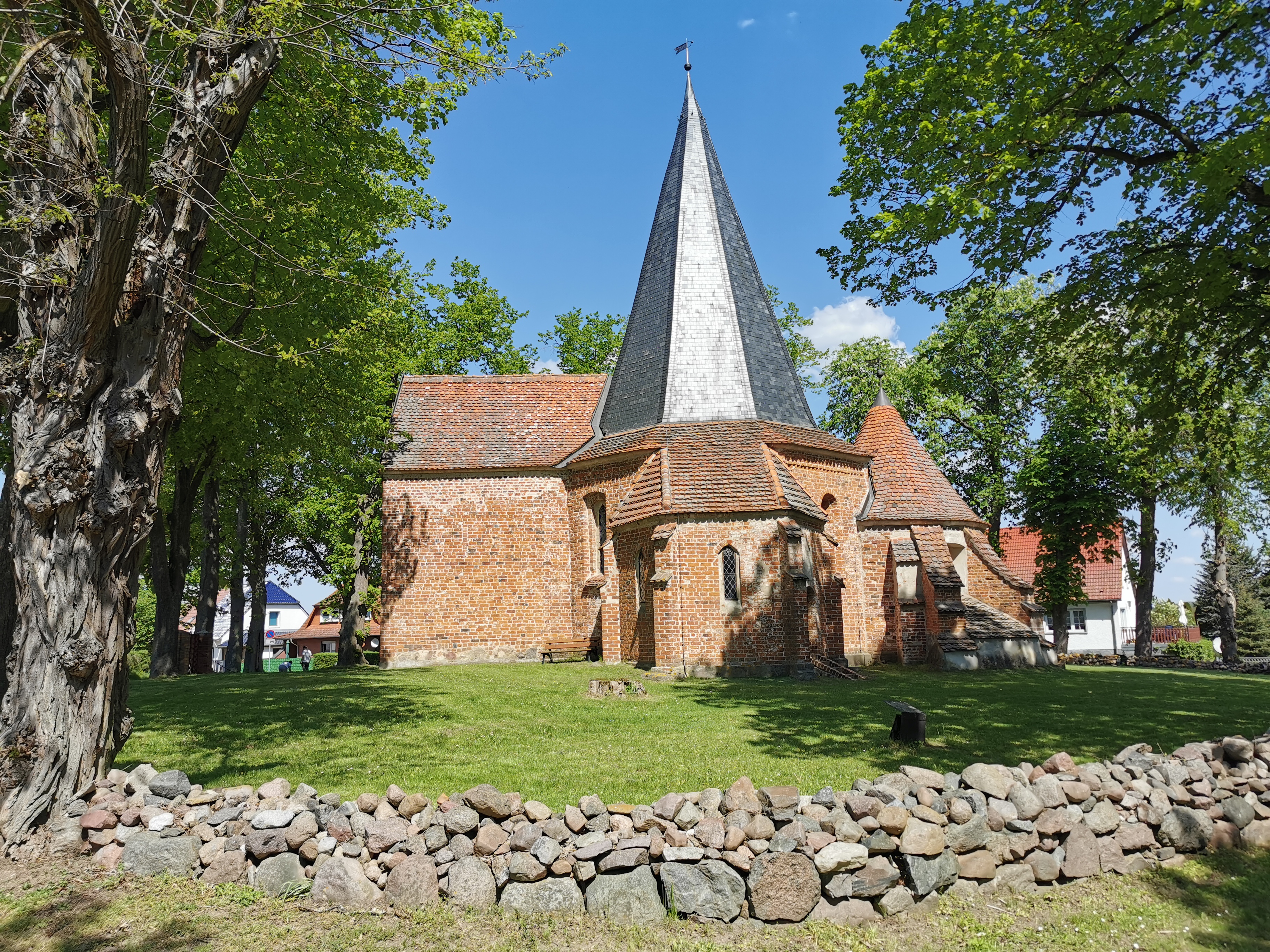
The following day we left Saranda early and drove eastwards towards the interior of the country, stopping along the way to see the Monastery of Saint Nicholas. We were lucky enough that a small tour group had just left so the guardian who occasionally opens the church for tourists was there. We tipped him some coins and then proceeded to visit the nice monastery. Located in the middle of nowhere in the countryside of a little sparse village called Mesopotam, this once thriving monastery was built during the 13th century in a typical brick Byzantine style. It was also enclosed by a circular wall now only partly surviving. The interior featured reutilized ancient Greek and Roman columns, some traces of medieval frescoes, and a nice wooden iconostasis. After thanking the caretaker we were off driving towards the Gjerë mountains which form a wall running north to south. Along the way, we saw a sign indicating the famous Blue Eye, a water spring with crystal clear deep blue waters. However, as it was raining we thought that it would not look as nice as in the photos so instead just continued on. Once we crossed the mountains we were in a valley formed by the Drino river and bordered by more mountains to the east and close to the Greek border. As we drove on we then took a small detour to visit the ruins of the ancient Roman city of Hadrianopolis. To get there we took a country road where we then came across a herd of sheep blocking the way. We had to go really slow but as it was drizzling we weren't in a hurry. Once at the site we dismounted and explored the area. Not much was excavated, of a site which is probably much larger, but we could see the ruins of the baths and of the theatre. As we were walking about the flock of sheep arrived to graze there and one of the shepherds approached us. He beckoned to us and once there tried to speak to us in Albanian. Obviously, we couldn't understand but he insisted we drink from his flask. We tried to refuse politely but he kept on insisting. Marcel managed to spill it without him noticing while I was being watched closely so had to take a sip, regretting it after the strong alcohol flowed down my lips. After a few moments of trying to leave, we managed to reach the car once again and drove off to the next town, Gjirokastër. Located at 300m on the foothills of the Gjerë mountains, the old town is a UNESCO World Heritage Site and is described as a rare example of a well-preserved Ottoman town, built by farmers of large estates. We parked the car at a parking spot we found along the road and then continued on foot. The city is characterized by houses consisting of tall stone block structures with roofs covered with flat-dressed stones that have earned the city the nickname "City of Stone". Despite the light rain we walked through the pretty central streets lined by such houses and buildings. This area was known as the bazaar as it was where all the local commerce took place, and still to this day is the main tourist part. We then visited the Bazaar Mosque, built in 1757 and with a nice frescoed interior. After the visit to the mosque the rain stopped so we decided to continue our walk through town. We then started heading uphill until we reached the Gjirokastër Fortress which dominates the town at its highest point and overlooks the strategically important route along the river valley. After paying the entry ticket we walked through a long tunnel that held captured artillery of the Communist resistance against German and Italian occupation. A small museum, which required another entry ticket, then had an exhibition on other equipment and memorabilia of WWII as well as other objects from the communist period and the castle's prison which was used extensively by Zog's government and housed political prisoners during the Communist regime. The northern part of the fortress, where the oldest part is set, held a large open space with some of the structures such as the defensive towers, a clock tower, former stables and prisons, fountains, and a church. There was also a captured United States Air Force plane from the 1970s, to commemorate the Communist regime's struggle against the imperialist powers. From the fortress walls, we also enjoyed a beautiful view of the town below and the surrounding landscape. Once we had seen the landmark we then headed back down to town and then went to see one of the typical manors in town, Zekate House. Located in the upper hilly area of town, away from the central bazaar area, this mansion was built in 1812. A perfect example of ottoman style fortified tower house, known as kullë in Albanian), it belonged to a wealthy family, the Zekate, whose descendants still own it to this day. The interior featured several rooms on each of the three floors, with wooden planks on the floor covered by carpets, sofas set around the perimeter, decorated wooden ceilings, and a fireplace for each room. The most beautiful room was on the highest floor most probably used by the owners and which had beautiful decorated wooden inlays all around its walls. After the visit to the fortified tower house, we headed back into town and to the car, driving further on our trip. We drove for a bit then headed up a narrow valley formed by the Vjosa River, called Aoos on its first part flowing in Greece. Most of its course is in Albania and it is considered the last wild river in Europe as so far no dams, gravel extraction, or other damaging activities have taken place along it. Just a month before our arrival the Vjosa Wild River National Park was created in order to protect its surrounding natural habitat which is a biodiversity hotspot, offering ideal aquatic habitats for over 1,100 species of wildlife, including otters, the endangered Egyptian vulture and the critically endangered Balkan lynx, of which only 15 are estimated to remain. Along the road, we stopped at a restaurant right on the river, Restaurant Gryka e Këlcyrës. It is located right above a narrow gorge and over some small waterfalls that drop right below it. The location was incredible but the service and food were so-so. Nevertheless, after lunch, we drove onwards up the Vjosa River until we took a street heading up another tributary of the Vjosa. After a few kilometers, we then reached our destination, the Benja Thermal Baths. It was lightly drizzling and was nearing sundown, so perfect to experience the hot water of these natural hot springs. We parked the car and then walked over to the little pool where some people were also taking a swim. To get there we had to cross the river on a medieval Ottoman arched bridge, the Kadiut Bridge, which was quite slippery. It was also really cold outside and unfortunately, the water was just lukewarm. However, it was still a cool experience and we enjoyed it quite a lot. Upriver, along the Lengarica Canyon, there were some trails heading to smaller and more secluded spots to enjoy the water but we were cold and wanted to be closer to the car so we just stuck to that spot. After the swim, it had started getting dark so we decided to start heading back to Sarande as in that area streetlights were non-existent and didn't wanna end up in a ditch. The drive took us nearly two hours and eventually, we reached the seaside city where we then went to sleep.
The following morning we woke up to a partly sunny day but we unfortunately had to leave. It was still a little chilly but all in all warmer than the previous days. We left Saranda and drove up north along the coastal road which passes along the so-called Albanian Riviera. This beautiful stretch of land is characterized by low mountains reaching the sea and small villages and towns set in olive-covered valleys with turquoise-colored sea. We stopped several times along the way, taking pictures and admiring the panorama. We had a longer stop at a locality known as Porto Palermo, called like this by Italian soldiers during WWII. On a little isthmus we then visited the Porto Palermo Castle, most probably originally built by the Venetians but later turned into a fortress in the early 19th century by Ali Pasha of Tepelene. After driving past more towns a steep drive then led us to the Llogara Pass, the only way to get from the seaside past the high Ceraunian Mountains to the other side, to the Dukat Valley, and then the city of Vlore. Once we got to the top of the pass, at more than 1,000m above sea level, we could see right below us the beautiful beaches of the Albanian Riviera and the deep blue waters of the sea. As we drove north from the pass and down towards the Dukat Valley, what surprised us was that the vegetation changed completely. It got foggy and there were pine trees all around, typical of mountain landscapes. We were in fact as mentioned at over 1,000m, yet as the pass was facing the sea the climate had been much milder. Once down in the valley, the sun was out again and much warmer. We drove through and past the large city of Vlore, the second largest in the country, and now with a nice waterfront and modern buildings, and lot of which were under construction, signaling it will potentially become a very hip and touristy city. Driving northwards we then took the first highway, the one connecting Vlore to Tirana, and eventually exited to visit the beautiful archaeological site of Apollonia. Once there we parked the car and had to walk a little to reach the site entrance. We then paid the entry fee and headed on to visit one of the most important Ancient Greek, and later Roman cities in Illyria. The first monument we visited was the church of Saint Mary, founded by the Byzantines during the 13th century in brick and rock, with ancient salvaged materials such as stones and columns. In the church's former monastery, we then visited the archaeological museum exhibiting all those objects and artifacts excavated from the archaeological site from prehistoric to Roman times. In what was the refectory we then found beautiful frescoed walls as well as a nice example of a well-preserved mosaic with animal scenes. Next up it was time to explore the ruins. We started out with the main area that included the Buleuterion, a building that once housed the city council and dates back to the 2nd century B.C. In front of it, as this was the city's monumental center, we then passed by the ruins of an ionic temple, triumphal arch, sacellum, library, and theatre. At that point, we followed the profile of the long stoa, once a covered walkway or portico, and passed by the ruins of some storehouses and a cistern. From there, a path led up the hill to where the walls that encircled that once huge city of 60,000 inhabitants stood. Here we also found some bunkers built during the communist period. Finally, after one last walk around the perimeter, we headed back to the site entrance and back down to our car. In about one hour we then reached the city of Berat where we would spend the next two nights. This town, inscribed in the Unesco World Heritage list, comprises a unique style of architecture with influences from several civilizations that have managed to coexist for centuries throughout history. Its current aspect is that taken mostly during the Ottoman period, with typical stone houses featuring many large wooden framed windows. so much that it took the name "Town of a Thousand Windows". After reaching the place we struggled to park at our accommodation which was in the old town with narrow and disheveled streets. Here to we slept in different accommodations, but our guesthouse was right in front of the other. Our place was really nice, with a nice room, and a beautiful terrace overlooking the old town. After dropping off our stuff we decided to explore the town and head out to eat. The other two decided to stay in their place, so Ania and I headed uphill to reach the upper old town. Berat is in fact characterized by two separate parts. There's a lower town on the Osum River, itself divided into Magalem the traditional Muslim neighborhood to the north of it, and Gorica the traditional Christian one to the south. And then the Kalaja, or castle, the old town located on a hill above the river, fortified by walls. We headed to the latter part, from our accommodation in Mangalem, and after taking a steep path through a forested area entered the walls through a postern gate on the eastern side. Here we then reached a small restaurant called Temi where we shared a salad and rice-filled bell peppers, plus I had also a dish with some kind of meatballs in a tomato and bell pepper sauce. As we finished eating it had gotten dark but we headed to the southern part of the upper town, where the cliff rises up from the river and where we had a beautiful nightscape view of the rest of Berat below. It started raining so we decided then to head back down to our accommodation to sleep. In the morning we had a great breakfast on the terrace with the sun out to shine. The other two were sleeping still so we decided to head out and explore the town early. We crossed a relatively modern metal bridge over the Osum River and then reached the Gorica neighborhood. Here we visited the small church of St Thomas built in stone on the upper part of the slope. Then we continued on and walked through the pretty narrow streets of this part of the old town. The pavement was a bit disheveled in many parts and there were still lots of wires and electricity cables hanging from the houses and dangling above our heads. Maybe in a few years with more tourists coming they will eventually put them underground to make it even more picturesque. Reaching the end of the neighborhood we crossed back to the other side using this time the Gorica Bridge, originally built from wood and later stone in 1780 but rebuilt in stone in the 1920s following a destructive flood. Once on the other side we walked to the modern part of town to the northeast and passed by the 17th-century clock tower. Then after a bit of walking, we turned around and headed back to the old town. We walked through the upper streets of the lower part enjoying the nice picturesque alleyways and sights of the city. Then we braved once more the tough hike up to the Kalaja neighborhood. This time we entered through the main castle gate on the northern end and proceeded to walk around admiring the main sites. We passed by the small church of Theodore, one of the many Byzantine churches in town, which was closed, and then reached the Dormition Cathedral. The entrance was paid for as it included the Onufri Iconographic Museum, a small space to honor Onufri, one of the most important painters of Orthodox murals and icons in the early post-Byzantine era in Albania. We first visited the church itself which featured a beautifully decorated interior, particularly the wooden iconostasis from 1806 with its icons. After a walk through the nice icons museum, we then headed out again and continued on our walk. We reached the church of St. Mary of Blachernae, which was supposed to have a beautiful frescoes interior but it was unfortunately closed. In front of it were the walls fully encircling the upper old town and from there we had a great view over the landscape to the west and its mountainous terrain. A little further on, uphill once again, we then reached the typical Byzantine structure of the Holy Trinity Church, built in the 13th century but closed as well. Here we then met up with Monika and Marcel who were coming down from the path we were heading up. We said hi, talked about our day so far, and then split up again each one going the other way to continue the visit. Above the church we then saw a large and deep water cistern, located in the highest point in town, and what was probably once the last defensive position in case of attacks, thus the need for such a cistern. Moving on, we walked along one of the streets and past two ruined mosques, the White and Red mosques. At the end of the street we reached the viewpoint we had stopped at the previous night and this time, during the day, managed to admire the beautiful panorama of the surrounding mountainous landscape and the old town below. Next to the viewpoint we then took a steep zig-zagging path that took us down the cliff and to the 13th-century Byzantine church of St Michael. Inside a guy asked me where I was from and then proceeded to talk to me in Italian. In fact, among the older generations, as well as some younger ones, I had found quite a lot of people speaking Italian in Albania so far. I left him a little tip and then we moved down through the narrow streets of Magalem. Close to the river we then visited the Lead Mosque, because of its roof's material, built in 1554. At that point dinner time was approaching so we decided to look for a place to eat in the lower part of town. We ended up going to Friendly House, a nice restaurant in one of the typical stone houses where I had kofte with fries and a kind of cheese and bell pepper dip while Ania had rice-filled eggplants and bell peppers. Once done we headed out to walk a little more by nighttime. We passed the nearby Bachelor's Mosque, built in the 19th century and with frescoes on the exterior, and then I decided to stop at a place to buy a crepe. It was huge, filled to the brink with Nutella, and really cheap: my type of dessert.
In the morning after waking up early and having breakfast on the terrace once again we then gathered our stuff and left with the car, driving eastwards up along the Osum River. The road was narrow but nice and well-paved, and we stopped here and there along the way to enjoy the scenery and take pictures. After a bit of driving, we then reached the Osum Canyon viewpoint, from where we could admire a beautiful section of the gorge formed by the Osum River. This 26km long gorge with cliffsides reaching up to 80m high, is a popular place with rafters but it can also be enjoyed by other visitors as well. After that, we drove on a few more hundred meters until we came to a parking spot next to a kind of church. From there we followed a well-hidden narrow and steep path that led us down the side of the gorge to a rocky beach. We enjoyed the view but the water was still too cold to take a swim in. As we had our lunch there, we saw some rafters paddle by as they went on down the river. After the nice break, we followed the path back up and drove a couple more kilometers upriver for the last viewpoint. Once we had seen enough, we then drove the way back to Berat and stopped on the way to visit a popular waterfall. After parking the car nearby, we then had to walk about twenty minutes through a badly kept path made by excavators, who will surely ruin the area in the future, until we reached said Bogova waterfall. There were quite some people there but the waterfall was small and quite unappealing. It reminded me a lot of the Grotta Azzurra near the town of Mel in Veneto. Finally, once we were back to the car we then drove 2h 30 to reach the seaside city of Durrës. Traffic there was terrible and it took us quite a bit until we managed to find a parking spot close to our accommodation. We also gathered throughout the rest of the time there that this was the city with the rudest people in the country, a statement confirmed by Albanians from other cities we had met. Nevertheless, after checking in the nice apartment, we then decided to have a stroll around the city and look for a place to have dinner. We reached the large and nice seaside promenade where we then had dinner at the Tivari restaurant where I had a decent tagliolini with scampi. After eating we then had a stroll back to the accommodation, ready then to go to sleep. On the way we stopped for ice cream, while I had another Nutella crepe, this one smaller and much more pricy.
The next morning we woke up and looked for something to eat for breakfast. We found a bakery and just grabbed some croissants to go, while Marcel and Monika had bought stuff the day before to eat at the apartment. Then we were off to explore the city passing by its main monuments. Durrës, or Durazzo as it was known during its permanence under the Republic of Venice, is one of Albania's oldest continuously inhabited cities, with roughly 2,500 years of recorded history. Our first encounter was the Byzantine market square, featuring a circular portico with marble columns all around it, some of which still standing. Moving on we traversed the main square, with a modern mosque and some soviet styled buildings, before reaching then the main monument in town, the Amphitheatre of Durrës. Only three quarter were excavated, its construction began under the emperor Trajan in the 2nd century AD but was destroyed twice by earthquakes in the 6th and 10th centuries. It is considered the largest Roman amphitheater in the Balkans, once being able to hold up to 20,000 people. After enjoying its sight we then walked along the old Byzantine walls until we reached the Venetian tower, built in the 15th century over pre-existing Byzantine defenses alongside other towers but the only remaining one to this day. From the tower, we then walked along the waterfront promenade, past the futuristic-looking pier, and westwards along the coast until we reached a nice small beach. Here we laid out our blankets and relaxed a bit in the nice warm sun. I then decided to take a swim in the crystal clear yet cold water. Marcel then followed my example but we didn't last long inside and quickly came out to dry. After a nice time at the beach, we then chose one of the seafront restaurants in the area and opted for, 2 Kitarat Aromë Deti, which had a nice setting with the tables right above the waterfront. I had spaghetti with shrimp, zucchini, and cherry tomatoes but the dish was so-so. Finally, we then headed back across the city and to the car, ready to drive on to our next destination, Shkodër. The drive took about two hours, and once there we got dropped off at our accommodation in the city center as this time Monika and Marcel had booked a hotel in the hills to the south of the city. After checking in we had a quick stroll around and then headed for dinner. What we were pleasantly surprised about the city was the amount of people on bicycles, so much so that it is known as Albania's bicycle capital. For dinner, we opted for the Aroma Restaurant where I had a dish with beef and potatoes while Ania took a huge salad. After eating we then walked through the old town, passing by the large Ebu Bekr Mosque, and along the main street which was filled with shops, restaurants, bars, and lots of people, especially young ones.
The morning after we had a similar stroll around town, this time with daylight, and then stopped at the Stolia Coffeehouse to get breakfast. At that point, as the other two did not wish to move from their hotel, we decided to walk all the way to Rozafa Castle, south of the city. The walk to the fortress took nearly an hour and the temperature had gotten quite warm lately. After reaching the site we paid the entry ticket and explored the large defensive structure built on top of a hill overlooking the Buna, Drin, and Krin rivers which join right in that spot. Originally an Illyrian fortification it took its current form, despite being partly ruined, during the Venetian period. We entered the site through the main gate, to the north, and then walked around exploring the ruins. The view from the battlement walls was worth the visit already. To the north, the snow-capped peaks of the Albanian Alps, to the west the huge Shkodër Lake, and to the east and south the large expanse of the river plains. Moving on we passed through the ruins of the Venetian St Stephen Cathedral, later turned into a mosque, and some cisterns and Ottoman dwellings, before reaching the highest point where the Capitaneria, where the Venetian governor used to live, was located. After walking around the rest of the complex we then headed out and back down toward the city, this time turning south and walking towards the Buna river. Here we then got picked up by Monika and Marcel and together we drove along the southern shore of the Shkodër Lake. We drove to the village of Shirokë and found a small beach where we then relaxed for a little while enjoying the beautiful view, peace, and calm. To the north, across the lake, the beautiful mountains loomed over the water, and to the west not far away, the border with Montenegro. A man who had stopped there as well with his bicycle then talked to us for a bit, both in Italian and German, about his time in those two countries and his life now back in Albania. Once we were back at the car we then met a group of stray dogs who initially barked at us but then jumped on me quite friendly; one of them a scruffy small black dog looked the cutest as he was also bossed around by the others, but still seemed to enjoy being with them. At that point, we then drove to Monika and Marcel's place until after dinner. We first had a swim in the pool and then ate at the hotel's restaurant where we shared a cheese and salty stuff platter, pickled vegetables, bread with some kind of yogurt sauce, potatoes, and grilled white cheese. I then also ordered a plate with shrimp in tomato sauce and we had some wine while enjoying the nice view of the Rozafa castle and the mountains in the distance. After eating we then drove into Shkodër where we got dropped off at our accommodation.
The next day we drove together north of the city to reach the Mesi Bridge, an Ottoman bridge over the Kir River built in 1770. It features a typical arched style with a large central arch and many smaller ones to the sides. There we other visitors there as well, and after taking some pictures we were back in the car. After about 1h 30 driving we reached the town of Krujë, on mountainous terrain at 600m above sea level the foothill of Mount Krujë. Once we parked the car we continued on foot and first stopped to eat lunch at the Bar Restorant Eli. The place was so-so and I had kofte with fries. After eating we then started exploring the town's main site, the Krujë Castle. The town is famous all around the country and has become quite a pilgrimage site for Albanians and Balkan people alike. Back in the 12th century, Krujë was the capital of the first Albanian state, the Principality of Arbër. Later it became the capital of the Kingdom of Albania, being later conquered by the Ottoman Empire in the 15th century. However, it was then recaptured in 1443 by Skanderbeg, an Albanian feudal lord and military commander of the League of Lezhë who led a rebellion against the Ottoman Empire in what is now most of the Balkan area. He successfully defended the town against three Ottoman sieges until his death in 1468, becoming a martyr which is still celebrated to this day. The Ottomans eventually took control of the town after the fourth siege in 1478 and incorporated it into their territories. The town's castle was a major site of that period and nowadays even features a Museum dedicated to the hero Skanderbeg. Among the four of us, I was the only one to visit it; the price was quite high and despite there being a lot of information it was not as exciting as I thought. It was obviously aimed as a memorial site for the people of Albania and surrounding countries, as was attested by the large groups of school kids and other families visiting. After the visit to the museum, we then explored the rest of the castle, which included some restaurants, houses, and the ruins of some monuments such as the Fethiye Mosque and the main keep tower. From the castle we then walked back down into the old town, walking through the picturesque cobbled street lined with typical Ottoman-styled low houses all now turned into a large souvenir bazaar. We bought some stuff there to take home and then headed back to the car. We finally drove to Tirana, Albania's capital, with the terrible traffic we noticed as we approached. We parked the car next to our accommodation and then went on to walk a little around the area. We just managed to reach the huge central square, Skanderbeg Square, designed by Italian architects between the 1920s and 1930s. We took a few photos and then headed back as Marcel and Monika would need to drive outside the city to their hotel as they would leave the morning after really early. For dinner, we had a gyros at the OPA - Greek Street Food.
The next day we woke up later than usual and after breakfast went out to explore the city. We first passed by the Tanners' Bridge, an 18th-century Ottoman-period stone footbridge, and then by the huge Namazgah Mosque, still under construction and which will become the largest mosque in the Balkans. Nearby we passed the ugly and modern catholic St. Paul's Cathedral from 2002 and then walked through the castle, which now only features part of the exterior walls while the interior is an array of chic and expensive restaurants and shops. Moving on we passed by the Clock Tower built in 1822 with next to it the nice Et'hem Bey Mosque from the early 19th century and with a beautifully frescoed interior. We were back at central Skanderberg Square, but the National History Museum to the north was unfortunately closed for restorations. We decided then to visit the Bunk'art Museum, a fascinating history museum and contemporary art gallery with exhibits from the Second World War and the Cold War. The bunker was built under the orders and direction of Enver Hoxha during the communist regime in the country alongside 750,000 other ones throughout the country totaling a whopping average of 5.7 bunkers for every square kilometer. We took quite some time learning about the troubled past of 20th-century Albania. Getting hungry we then decided to look for somewhere to eat. We opted for Veggies, a vegetarian restaurant where I had a quinoa salad with avocado and eggs while Ania had an Asian noodle salad. After lunch, we continued our walk and reached the Grand Park of Tirana, as the name suggests, a large park on the southern limits of the city. Here we strolled through the nice pathways lined by trees and with a large lake at its center. Back in the city we then sat on a bench to relax a little and a cute stray dog decided to just sit between the two of us and relax with us as well. Finally, for dinner, we decided to eat pizza and chose a traditional Neapolitan pizzeria where we had a really tasty pizza, salami for me, and zucchini for Ania.
It was then time for us to leave, so after waking up late, we had a stroll around the city, grabbed lunch at the Greek street food chain, and then headed for the airport with the bus where we eventually took the plane back to Berlin.
 |
| The interior of the Cathedral of St Spyridon |
 |
| The Old Venetian Fortress |
 |
| The church inside the fortres |
 |
| The view from the fortress |
 |
| A street in the old town of Corfu |
 |
| Another street in the old town |
 |
| A street which looks a lot like Venice |
 |
| The Doric Temple of Kardaki |
 |
| The Panagia Vlacherna monastery |
 |
| The city beach in Sarandë |
 |
| The Basilica in Butrint |
 |
| The ancient theatre |
 |
| The beach in Ksamil |
 |
| View of Sarandë |
 |
| The Monastery of Saint Nicholas in Mesopotam |
 |
| Street in the old town of Gjirokastër |
 |
| The fortress |
 |
| The museum inside the fortress |
 |
| The interior of Zekate House |
 |
| Another street in the old town |
 |
| The Vjosa River valley |
 |
| A beach along the Albanian Riviera |
 |
| The castle of Porto Palermo |
 |
| The monastery church in Apollonia |
 |
| The Buleuterion |
 |
| Ruins in the archaeological park |
 |
| A shepherd and his sheep |
 |
| View of the old town of Berat |
 |
| A street in the old town |
 |
| The interior of the Dormition Cathedral |
 |
| The Holy Trinity Church |
 |
| The Osumi Canyon |
 |
| The Roman amphitheatre of Durrës |
 |
| The Venetian tower |
 |
| The beach near the city |
 |
| View of the Albanian Alps |
 |
| The city center in Shkodër |
 |
| View from the Rozafa castle |
 |
| Lake Shkodër |
 |
| The Mes bridge |
 |
| Krujë castle |
 |
| The bazaar |
 |
| The old town and minaret |
 |
| Bunk'Art 2 in Tirana |