The day to start the pilgrimage had arrived, and after an early rise I checkout out from my hotel in Ancona and took a local bus which brought me to the nearby village of Portonovo. Located just east of the city, this little area which consists of a few scattered buildings is known for being part of the beautiful Riviera del Conero, a stretch of coast around the Monte Conero with high and rocky cliffs and incredible beaches. It was from here in fact, that I intended to start my walk all the way to Florence. The plan for the first day was to hike from Portonovo up the Monte Conero and back down the other side and then reach the town of Loreto. So after getting off the bus, I decided to check out the beach of Portonovo, just a few minutes' walk from the bus stop. As I approached the sea I was immediately mesmerized by the beauty of it: a white beach sharply contrasting with the crystal clear blue waters. It's been a while since I had last seen such a beautiful color of the sea, and at that moment I thought it was the nicest I had ever seen. The water was so inviting but I could not afford to have a swim before even beginning the walk so I decided that I would stop later down along the coast. I found a few locals working there so I decided to ask them for a direct way up the mountain. They said the cliff was too steep on this side so I was supposed to head back up along the road and find another way up from that side. That, unfortunately, meant I had to walk 30 minutes back up the same way I had come down with the bus and from there followed another street up the mountain. That did not discourage me though so I tightened my backpack and started the ascent. After reaching the fork I then followed the signs which led me through the small town of Poggio where I was able, after a few hundred meters to finally find an official signpost indicating the way up the mountain. I followed the trail which began through a beautiful Mediterranean flora consisting of cypresses, Aleppo pines, and oak. At one point I reached a nice vantage point from where I could spot the beaches of Portonovo and Mezzavalle below creating a nice bay. After a little more walking I then finally reached the highest spot of the Monte Conero, located at 572m above sea level. Here was also the ancient Badia di San Pietro al Conero, a romanesque church that stands here since the 11th century. A small note carved on the walls of the monastery warned that no women were allowed in the place, once a common rule for secluded religious orders. Nowadays the church and the monastery are part of a nice hotel with a bar next to them that serves hikers, visitors, and guests alike. The way now was all downhill but not as easy as it was steeper and more rocky than the way up. Not too far from the church I then reached the most beautiful panoramic spot of the entire mountain. From here in fact I could admire, straight down below me, the beautiful Spiaggia delle Due Sorelle, a secluded beach that can only be reached by boat. In fact, there used to be once a trail heading down from the mountain, however, due to high risk and occasional accidents it was closed off. The crystal clear waters were so inviting especially now that I was so hot and sweaty from the hike. After enjoying the view for a while I then back on the trail and followed it for a while downhill, encountering a little deviation at one point which I followed. It led me in a few minutes to the small Grotta del Mortarolo, a cave once probably used as a refuge by the locals. After that deviation, I then headed back to the main trail and continued downwards until I finally reached the town of Sirolo. The whole hike took me just over three hours, two heading up and one heading down. I was now quite hungry so I decided to look for a supermarket to grab some food. I bought a few things and then decided to head to the beach to enjoy my food with a view. I found the nice large beach, Spiaggia di San Michele, just north of Sirolo which I reached by heading down a cliff bordering the town. Here I enjoyed my lunch with an amazing view of the Conero cliffs caressed by the crystal blue waters of the Adriatic sea. Before leaving the beach, I then took a long refreshing swim and basked in the sun for a while, taking some needed rest after the first part of the hike. I was then recharged to continue my walk and headed up the cliff to visit the small town of Sirolo right above. The city center is surrounded by a thick late medieval wall which helped the town from invasions throughout the centuries. The streets are narrow and picturesque, and despite resembling those of towns in the inner countryside the seagulls squawking made it sure I was right by the sea. After reaching the northern end of the old town where the small church of San Nicola di Bari is located I then stopped at the terrace which borders the city to the north and east and overlooks the cliffs. Here I had a beautiful view of the Monte Conero and the beach where I had lunch before. After admiring the view I then turned around and walked back through the city, exiting to the south and heading forward towards my destination. After just a few minutes I was then traversing the small town of Numana, the southernmost part of the Riviera del Conero. Smaller than Sirolo and more modern it featured some historical buildings and a nice staircase leading down towards the sea. From then on the way was flat and straight along the seafront. After a few kilometers like that, I then left the seafront and headed through the grain fields finally able to clearly see my destination right in front of me on a hilltop: Loreto. As I approached the town from the sea, so from the east, I started the ascent of the hill on which it stands and stopped by the Polish War Cemetery halfway. Built after the end of World War II, it is one of four polish war cemeteries in Italy and serves to commemorate and hold those Poles who died in the Italian campaign. The place was peaceful and quiet and had an amazing view of the surrounding landscape and Monte Conero in the background, I couldn't imagine a better place to rest forever. After visiting the cemetery I walked a little bit further uphill and finally reached the town proper. Loreto is quite small and revolves around the most important monument which sits at its center and highest point: the Basilica Della Santa Casa. The Basilica is one of the most important and ancient places of Marian pilgrimage in the Catholic world. It is known for enshrining the remains of the house in which the Blessed Virgin Mary is believed to have lived in Nazareth and where now an image of the Madonna with Child is kept. The construction of the building itself was started in 1468 in a Late Gothic style which soon transitioned into Renaissance. On it worked some of the best architects of the period, such as Bramante and Sangallo. The whole structure took nearly a century to complete and thus some parts are in full Renaissance style, such as the impressive white marble facade. The tall bell tower was added much later, in 1754, by Luigi Vanvitelli. The large interior, the church in fact measures 93m long and 60 m wide, is gothic in structure with Renaissance paintings and frescoes. At the center of it, right below the frescoed cupola, stands the Santa Casa, or Holy House. This is the pilgrimage destination itself where the image of the Madonna is kept. It consists of three stone walls a door on the northern side and a window on the western one and measures 8.5 m by 3.8 m and 4.1 m high. The interior is quite unadorned apart from the altar with the Madonna and child. Photography was not allowed inside and there was always someone watching though I managed to slip one photo just for keepsake. The walls are englobed by a beautiful marble screen designed by Bramante representing scenes of the Annunciation, Nativity, Nativity of the Virgin, and Arrival of the Santa Casa at Loreto. Once I had seen enough of the church I then exited through the main door and into the large square, Piazza Della Madonna, which features a beautiful baroque fountain, the Fontana Maggiore, at its center, and is surrounded by the arcaded Apostolic Palace to the north and west, designed by Bramante at the beginning of the 16th century. The whole complex created a spectacular setting leading me to think this one of the nicest squares I had ever seen. From there I then headed through the rest of the town and in the direction of my accommodation. I found a small Airbnb called Gli Angeli and when I arrived a kind lady showed me in; the place was really nice, clean, and modern, and all for myself as I was the only guest there. After unpacking I was finally able to take a nice shower and get the sweat and tiredness off of me after this long first day, totaling about 31km. For dinner, I decided to find a place nearby and ended up eating a tasty hamburger with fries and a beer at the Cantina del Moro right across the street from my accommodation. Later that night I then received a call from my parents who decided to come to see me as they were vacationing with some friends in the area. We met at the main square, had a little walk and chat together, and then waved goodbye as I needed to head to sleep ready for the next day.
The following morning after an early rise, I decided to stroll around Loreto once more before starting the second day of hiking. I went back to the main square and visited the Basilica again, this time nearly empty due to the early hour. Then I headed to the terrace just north of the town walls where I admired the beautiful panorama of the countryside and Monte Conero in the distance, even nicer now due to the crisp clear sunny day. It was then time to head on towards the day's destination and so I pulled out my phone and followed the trail on the map. The signposts for the Via Lauretana were not visible as I walked westwards, but that didn't particularly matter as I knew where I was heading: I could already clearly see the town of Recanati in the distance on a hilltop. The walk from Loreto to Recanati took just over an hour through placid hilly terrain surrounded by wheat and grain fields. As I approached the town from the east I was met by the imposing walls that surround it and went through the nice medieval city gate, Porta San Filippo. Once inside the old town I walked along the main street, Corso Persiani, and found a church, that of Sant'Anna open so went ahead and visited it. The interior did not hold anything particularly interesting apart from a nice copy of the holy house of Loreto where the altar is located. Just a few meters from the church I then reached the nice central square, Piazza Giacomo Leopardi, with the 19th-century imposing town hall to the east and the 15th century Torre del Borgo, a medieval tower that was once attached to the Palazzo dei Priori nowadays non-existent anymore. As I continued on past the main square and back through the main street, on this side now called Via Cavour I found a large entrance door to a palace open and decided to take a peek at the courtyard which I could see in the back. The palace, called Palazzo Venieri, now holds a high school but the courtyard gives way to a terrace with a beautiful panorama. On top of the high walls and looking east I could clearly see the sea in the distance, as well as the cupola and bell tower of the Basilica of Loreto and the ever-present Monte Conero close by. After enjoying the view I headed back to the main street, followed it for a bit, and then came across the church of Sant'Agostino. Built during the 13th century in a Gothic style it suffered some refurbishments in the following centuries which altered particularly its interior, now plainly baroque. Particularly noteworthy were the renaissance marble portal and the bell tower which is the highest in town. Not far from the church I then reached the eastern end of the old town, marked by another city gate, the Porta Marina, this one built in a Baroque style. From there I meandered through some narrow yet picturesque streets until I reached a small square at the southern end of town where the imposing Palazzo Leopardi is located. This building is famous for being the birthplace of Giacomo Leopardi, a famous Italian poet who lived most of his life here and whose poems often mention the town and its surroundings. The building hosts now a museum on its ground floor where the poet's library is located while the upper floors still belong to his descendants nowadays. I didn't have the chance to visit the museum as, due to covid restrictions, only a certain amount of people were allowed in and the visit was only possible as part of a guided tour so there weren't any available tours in the next few hours. Instead, I continued a little further and reached the southernmost tip of the town. Here on top of the Monte Tabor, one of the hills that make up the town of Recanati, I had an amazing view towards the countryside stretching all the way to the Sibillini Mountains in the distance. The hill is known as the Colle dell'Infinito, which Leopardi mentions dearly in one of his poems, imagining the view he could see from the garden of his villa over the small wall. The garden itself is part of the FAI organization and to see it another guided visit had to be arranged. I skipped that too but still enjoyed the view from the hill with the sun glistening and the strong wind breeze giving me a feeling of peace and serenity. After that, I headed back through the old town, past the main square, and reached the northern end of town where the Cathedral is located. A bit inconspicuous and out of the main area the building was begun during the 14th century but now features mostly the refurbishments that took place during the 17th century in a baroque style. Right in front of the Cathedral is the Villa Colloredo Mels, a medieval building turned into a palace and villa in the neoclassical style during the 19th century. It now holds the city museum which I decided to skip as I still had a lot of way ahead of me. As I exited Recanati, I turned once more to admire the idyllic group of old buildings gathered together on a hilltop and surrounded by gentle hills covered in wheat fields and dotted with olive trees. The sun was high up and strong, with not many clouds in sight but the breeze helped keep the temperature from rising and made the hike much more pleasant. After a couple hours walking among such beautiful countryside, spotting here and there some blooming sunflower fields, I then reached the small town of Sambucheto and a trafficked road. Here I managed to find a supermarket where I bought some food to eat on a nearby bench. The lunch break was a needed stop to relax, eat and get back some energy. From Sambucheto I then decided to take a little deviation and visit the nearby town of Montecassiano. Locate on a hilltop like most of the towns in the area it features a small but nice and quaint historical center. As I approached the old town I passed through the nice medieval gate, Porta Cesare Battista, which marks its entrance for those coming from the sea. At the center stands, imposing, the nice gothic collegiate church of Santa Maria Assunta with its slender and elegant bell tower. A few steps away, on the central square, Piazza Unità d'Italia, is the 15th century Palazzo dei Priori, a gothic monument which served as the government's building and now functions as the town hall. As I walked around I admired the town's pretty streets, all built in a circular motion starting from the top and heading down, and with the typical brick architecture of the area. I then headed outside the historic center and southwards in the direction of my day's target. As I walked along a trafficked road with no sidewalk I soon approached a little hamlet where to my surprise, I found some ancient ruins behind a fence. They were the ruins of a theatre dating to the 2nd century and belonging to the once-prosperous ancient roman town of Helvia Recina. The ruins were in quite a good shape, but unsurprisingly only viewable with a guided tour, so that meant just admiring them from afar and heading then onwards. I was finally approaching the city of Macerata, which like all others around, sits on top of a hill. A proper city, compared to the towns I had walked through so far, it was quite an impact to see so many people after the open and empty countryside and small settlements. The city is quite lively and holds a prominent university, one of the oldest in Italy, and the 8th oldest in the world, together with Coimbra in Portugal, and founded in 1290. As I walked through the main street, I admired some nice and lavish palaces ranging mostly from the renaissance to the baroque period. I then walked through the central square, Piazza Della Libertà, surrounded by the city's main monuments. To the north the Palazzo del Governo, a 15th-century palace once the seat of papal authority which governed the city, and the Loggia dei Mercanti a 16th-century arcaded building that served the prominent merchant community of the city. To the south of the square is the building which houses the 18th century Teatro Lauro Rossi and next to it the Torre Civica, the renaissance clock tower which features an astronomical clock as well, considered as the only one in the world that represents the lunar phases alongside the movement of the planets. And to the west and east, the Palazzo del Comune and the church of San Paolo respectively, once the town hall and the other a religious building now functioning as an auditorium. As I moved on I then passed by the beautiful Palazzo Buonaccorsi, a 17th-century palace that holds the city's main museum, and a little further ahead the Cathedral. It was unfortunately closed, as were all the other churches in the city which I then tried to visit, and it had me wonder if I had come at the wrong time. Later I had found that they were all closed due to renovations from the earthquake that had hit the area not too far from there, and which would be quite evident as I hiked westwards in the following days. Nevertheless, I continued on and exited the old town from the southern gate, passing by the large structure of the Sferisterio. This oddly shaped building, which now serves as the city's main theatre, was built in 1823 as the arena where the game of "pallone col bracciale" would be played. The game which is played with a ball and a bracelet featuring spikes that is worn by players has ancient origins and was played usually next to the city walls of any Italian city. During the 19th century, it became so popular that cities such as Macerata built an actual area where it could be officially played. I did not enter the building but admired its semicircular shape from the outside before finally heading on to my accommodation for the day. I had found a place to sleep at the Domus San Giuliano, a religious house located in the same building where the Seminary is to be found at the southern edge of the city. After checking in, unpacking, showering, and resting for a bit I then decided to look for a place to have dinner which wasn't too far away. I opted for Osteria Agnese just a few blocks from where I was staying, and where I found amazing food at a really good price. I ordered a pasta with tomato sauce and minced meat, which was so tasty I immediately ordered a second portion to the chef's surprise and delight. After a satisfying dinner, I headed back to sleep tired after a nice but long hike, for a total of 37km which I could really feel on my legs.
The next day I woke up at a decent hour and had breakfast in the accommodation as it was provided in the price; I filled up quite a bit and took some fruit with me to snack on the way. Then I left Macerata and proceeded southwards downhill across a hilly but pleasant countryside. After a few kilometers of fields after fields, I came across one of my intended stops that took me just off the main trail of the Via Lauretana. That stop was the Abbazia di Chiaravalle di Fiastra, one of the most important and best preserved Cistercian abbeys in the country. It is surrounded by a large nature reserve, set up in 1985 in order to protect the building and its surroundings, which I passed through as I entered the complex. The monastery, which flourished for several centuries, was sacked during the 15th century by Braccio da Montone which marked its demise. After passing through the hands of several religious orders it was finally given in 1773 to the Bandini marquises which held on to it until 1918. Then a foundation was set to preserve and turn it into a natural reserve and museum which can be seen today. The park around the main building was filled with families who were enjoying the sunny breezy day. I proceeded towards the main building where a ticket office was set for those wishing to visit the monastery proper. I bought the ticket and waited for the guided visit that took me and two other visitors inside. The tour took us through the church, a beautiful example of Romanesque structure transitioning into Gothic from the 12th century that was built by Cistercian monks from the Chiaravalle Abbey in Milan with the help of French monks that brought the style to the area. Part of its foundations was built through the reuse of materials coming from the nearby ancient Roman town of Urbs Salvia. After seeing the church we then moved to the monastery, walking through several parts of the building, including the refectory, chapter house, and the cellar and grottoes where the monks used to store the wine and olive oil produced on their lands. On the southern side during the 19th century, when the Bandini took over the complex, a palace was built where the family would live. During the fascist period, the palace was used as an internment camp where many prisoners and minorities were relegated. Today the palace houses the offices of the foundation and presents a beautiful English-style garden. Back to the monastery we then completed the tour by visiting the cloister which was refurbished during the 15th century and still features the well that collected rainwater at its center. Once the tour was over, I thanked the kind and decided to find a spot where to have lunch (which I had brought with me from the supermarket in Macerata). I found a spot on a bench in the shade and enjoyed my lunch while admiring the church's facade. Then I was back on track walking further in the direction of Urbisaglia. Not long after I approached a group of houses along a trafficked road, and found a small church that had its doors open. I headed in and was amazed at what I saw; most of its interior still featured some well-preserved frescoes dating from the 14th and 15th centuries. Moving onwards I then walked by the archaeological site of the ancient Roman city of Urbs Salvia, the largest in the Marche Region. The first ruins I came across were the ones of the amphitheater, one of the best-preserved in the region, with all its perimeter still standing but with some overgrown flora that made it look slightly not taken care of but was probably intended to be there and give it an aged look. Then I passed by the ruins of some other buildings such as the cryptoporticus and temple, and the theatre located on the hillside. I followed the path leading up the hill and past the theatre and reached the top where the town of Urbisaglia is located. I entered the old town, encircled by walls, by passing under the city gate, Porta Vittoria, and then followed the main street cutting through the center until I reached the large Piazza Giuseppe Garibaldi located at the southern end of town. Here was the collegiate church of San Lorenzo, which was still closed, and the nice castle of Urbisaglia, a 16th-century defensive structure with the forms and architecture typical of central Italy. As I then left the town heading westwards, I traversed a nice hilly landscape made up of meadows, agricultural fields, and forests, void of nearly any kind of humans or settlements for quite a bit. At one point I then reached a final hilltop from where I could see, in the distance, the town of Tolentino, the day's final stop. I headed downhill past some scattered houses until I reached the Ponte del Diavolo, an amazing example of 13th century stone bridge with a fortified tower at its beginning which served to control the traffic and extort tolls. Unfortunately, the bridge is still used by cars on both directions, and due to its age and narrowness, it is hard to move out of the way when two cars approach from each side. Nevertheless, it was a thrill to walk on such an ancient structure and to admire the view over the Chienti river. After reaching the other side I was in the old town proper, passing through the southern city gate and following a street that took me right in front of the Basilica of San Nicola da Tolentino. The facade, which I had read was a masterpiece, was unfortunately covered by scaffoldings, much needed after the earthquake that hit this area and the rest of central Italy in 2016. This was one of the first signs of the earthquake I had encountered along the way, and would be one of many coming up in the following days. The interior of the church was open so I decided to head in and have a look. Inside is a mix of styles, ranging from the Renaissance to the Baroque with some Neoclassical additions. Particularly noteworthy was the Cappella delle Sante Braccia, a 17th century chapel with gilded decorations and a frescoed cupola. Next to it is the Cappellone di San Nicola, the most important part of the Basilica; this Gothic chapel is known for having its walls and ceiling covered in early 14th century frescoes depicting scenes from the life of St Nicholas of Tolentino, Life of the Virgin, and episodes of the life of Christ. Despite the scaffoldings that covered this chapel too I was able to admire the beauty and skill with which the scenes were painted. From there a door then led outside to the cloister, a nice gothic example with the galleries decorated with 17th-century frescoes. After visiting the Basilica, I then headed out and walked around the building, passing through a nice small square with a baroque fountain at its center. A little further on I reached the Cathedral which was unfortunately closed, most probably due to the earthquake, as I noticed right next to it a whose that had partly crumbled down and some of the rooms could be clearly seen standing half cut in mid-air. I thus turned around and continued onwards through the old town, wandering aimlessly through its pretty streets but sadly admiring the large damage which the city had suffered. Then I reached the central square, Piazza Della Libertà, surrounded by some of the most important buildings in town, such as the 19th century Palazzo Comunale, rebuilt over a medieval one, the Palazzo Sangallo, built in 1932 on a design by the architect Sangallo, and the Torre degli Orologi, a tower which features four quadrants connected to a clock that show the phases of the moon, italic hours, the astronomical hour, and the days of the week and of the month. Not far from the square I then finally reached my accommodation, the Hotel Milano, where I unpacked my stuff, took the usual shower, and washed the clothes I was wearing. Then after a bit of relaxation and discovering that my room had a great view over the city I decided to head out to look for a place to eat. I opted for a place called Osteria San Nicola where I had a tasty lentil soup and trofie with boar meat sauce. It was then time to head back to the hotel where I finally laid to rest after another extremely long hike, totalling 33km.
Another day, another hike, this time I decided to wake up a little later as I was still quite tired from the day before. After getting my stuff and heaving breakfast downstairs I got my backpack on and set myself on the trail, crossing the Ponte del Diavolo once more. From there I followed a nice bicycle path that led me around the nice artificial Lago Delle Grazie, from where I could see in the distance, the town of Belforte del Chienti, which I reached not long after. The town is set on a hilltop so that meant climbing uphill for the last part quite steeply. After reaching it I walked through the small center which featured a nice central square with the nice Palazzo Comunale featuring the town's clock tower and a church dedicated to Saint Eustachius that holds a beautiful 15th-century polyptych by Giovanni Boccati. After admiring the great view that could be seen from a terraced part of the square I then headed on and downhill once again, passing by some nice fields filled with poppies. Shortly after, with a small deviation, I reached the town of Caldarola. Here I decided to buy some groceries to have later for lunch as it was nearing closing time. I then moved on through the old town, which I immediately noticed was mostly abandoned and filled with scaffoldings ad the town had been hit hard by the 2016 earthquake. The nice central square was surrounded by elegant buildings such as the Palazzo dei Cardinali Pallotta, the Collegiate church of San Martino, and the Santuario di Santa Maria del Monte. The two churches were obviously both closed and the latter's facade fully covered in scaffolding. As I continued on through the old town I admired the nice stone architecture but with a void feeling as all inhabitants were gone, many of the things still left behind in the houses. I walked up to reach the Castello Pallotta, a nice medieval castle that dominates the town from above but which was enclosed in a shell of wooden beams and iron poles. It was rather sad to see the whole city center in such a situation and still, after several years not much seems to have been done to set everything back to how it once used to be. As I continued on I then reached the Lago di Caccamo, another artificial lake created with the waters of the Chienti river. As I walked along its southern edge I came across a small archaeological area where the ruins of a Roman villa were set. Just a little further, up the hill, was the small town of Pievefavera, built right above the lake and surrounded by olive trees gradually descending towards the body of water. I walked through its pretty center made up of narrow streets, low arches, and the typical local stone architecture. As I reached the highest spot I decided to find a spot to sit among the high grass where to enjoy my lunch and the beautiful view in front of me. All around were orderly groups of olive trees and in the distance the lake with the surrounding low mountains. As I sat there for a while I realized I had been there a bit too long and needed to head onwards as there was still plenty of kilometers left before reaching my destination for the day. As I got back up I then headed down back through the old town and along the lake until I reached another small town, Valcimarra, civil parish of Caldarola. Here i followed the main asphalt road until I passed yet another civil parish, Bistocco, before venturing uphill through a remote valley. In fact from then on, I did not see or hear any person and did not see any kind of human settlement for well over an hour. It was just me, the surrounding forested valley, and the sound of my shoes over the white stone trail. After several kilometers like this, I finally came out of the forest and up to another asphalt road from where I could clearly see picturesque on a hilltop and in the far distance the town of Camerino. A few more hundred meters and I had finally reached my destination, the Capuchin convent of Renacavata. This small isolated monastery is set just a few kilometers from the town of Camerino and was the only accommodation I had managed to find. As I approached it I rang the bell and waited for the custodian to show me in. He showed me to a small room set on the western wing where I could spend the night; it was a bit shabby but at least I was alone, something which I would get to regret later that night as the convent was really in the middle of nowhere. After unpacking and showering I was surprised to hear that my parents, and brother who had joined them the previous day, had decided to drive all the way here from the beach town Porto Recanati and join me for dinner. After picking me up at the convent, we drove across the hilly terrain until we reached the nice restaurant, Pappafò Countryhouse with a splendid view over the mountains. Here we had a lovely dinner in the outside garden with a wide selection of first and second courses. After that, my family drove me back to the convent where I hugged them goodbye and thanked them for the nice night which I would have probably spent alone in my room. I headed to sleep tired but happy after another 28km walked.
The next day I woke up early and headed out quickly, in order to eat breakfast after reaching Camerino, just a few kilometers to the west. After walking first downhill and then uphill once more I reached the city and passed through the northern city gate that marks the entrance to the old town. Just a little further I then reached the large Basilica of San Venanzio, a late gothic church that was refurbished during the 19th century. The main porticoed facade in neoclassical style, hides the splendid gothic portal and rose window, while inside not much is left from its early period. In the crypt below the main altar is the gothic urn containing the remains of Saint Venantius. As I exited the church and continued uphill, I noticed there was no one around, shops were closed and the streets were empty. I figured out why as I reached the main square, where the Cathedral is located. In fact, all around the square, were buildings with evident scars from the earthquake, including the 19th-century Cathedral that was supported by wooden beams to maintain its stability. The building had in fact already suffered a tremendous earthquake in 1799 which had destroyed the gothic structure, needing then to be rebuilt a few years later. Another building of note is the Palazzo Ducale, on the southern side of the square. This renaissance palace was built for Giulio Cesare da Varano, lord of the Signoria di Camerino which ruled the city during its golden age. Nowadays the palace serves as the main seat of the University of Camerino, founded in 1336 and one of the world's oldest, but together with the rest of the buildings around was currently inaccessible. In fact, as I proceeded onwards along the main street, I saw all minor streets to the sides were barred by gates intimating to stay away as it was still a red zone and there was a high risk for debris to fall down. At one point I could not go onwards as all the streets were closed off, so that meant retracing back my steps all the way to the main square. Here a military patrol, which was checking the area and making sure no one tried to go through the red zone, helped me figure out a way to get to the other side of the city. They told me to head downhill a little, follow the road which follows the city walls and from there head back uphill. I did what they suggest and reached the southwestern edge of town where the Rocca Dei Borgia is located. This renaissance fortress was built in 1503 by Cesare Borgia, Pope Alexander VI's son, who had attacked and seized the city from the da Varano family. The city was taken back just a year later by Giulio Cesare's son, Giovanni Maria, but the name of the fortress was kept. The fortress now holds a park with beautiful views over the surrounding landscape, and the Appennines, so close now, were just an arm's reach away. After enjoying the view I continued on and passing through the modern area of the city where I started to see more and more people, as this area was not hit as hard as the old historic center. Here I found a bar which was open and decided to have breakfast there. The bar also had a tiny grocery store so I bought some stuff to have later for lunch, feeling that with my tiny purchases I might give some help as well. After filling up I then left the city of Camerino, heading southwest among gently rolling hills all around me. The way was easy straight and slightly uphill; the only human settlement on the way was the little hamlet of Morro, just a few kilometers from Camerino. From then on I didn't any other traces of humans even though I was following an asphalt road which was well kept. I followed the road for several kilometers and hours, only seeing the occasional herd of sheep grazing on the slopes of the nearby mountains. Finally, at one point, the road joined the main road where the occasional car would drive up once in a while. Not long after I then arrived in the small town of Serravalle di Chienti, located at the low point of the valley created by the Chienti river. Here I decided to stop and find a place in the shade where I could enjoy my lunch and cover from the sunny heat that had followed me in the past hours. As soon as I sat down on a rocky wall near some old houses in the city center, a dog which was laying nearby got up and approached me to see what was going on. He was obviously interested in what I had pulled out from my bag, so I decided to share some of my lunch with him as well. After eating I waved goodbye to my new friend and headed on through the pretty town, As I exited the town, I passed by the ruins of what was probably once the castle and keep built to guard and protect the valley and town below. Not long after I finally reached the plateau of Colfiorito which meant flat terrain after the interminable uphill way up to that point. The Plateau actually consists of seven small plateaus interspersed by low mountains that surround the town of Colfiorito at about 800m above sea level. The main plateau, which was the one that I had reached at that point, lies east of the town and is shared among the regions of Marche to the east, and Umbria to the west, where the town lies. As I traversed the large plain ahead of me, the sun started giving way to a strong wind and menacing clouds threatening thunder and lightning. The colors of the grass, fields, and flowers were however beautiful and distracted me from the approaching weather. As I passed through the last town in the Marche region, Taverne, I then reached a small solitary chapel, known as the church of Santa Maria di Plestia. This pre-romanesque building dating to the 11th century was built over an early christian basilica which was once part of the ancient roman town of Plestia. Around it are in fact some traces of its ancient past, and now only the church is a solitary testimony to its former glory. I found the doors closed, as expected, and as the clouds were becoming ever darker and menacing I decided to head onwards, speed up and push myself for the last remaining steps. In a few minutes in fact I had reached the town of Colfiorito where I would spend the night in the nice Hotel Lieta Sosta, just in time for the rain to start pouring. I had walked another 30km that day and started to feel tired as the kilometers were beginning to build on my legs. Luckily as it was raining I had a reason to spend the rest of the day inside the hotel and have dinner in the annexed restaurant. I had a tasty pizza and then decided to head to sleep early to get some well-needed rest.
In the morning I woke up at a decent hour, had breakfast, and then thanked the owner before leaving for my next destination. From here, in fact, my way departed from the official Via Lauretana as I finally decided and confirmed I would proceed further and end my pilgrimage in Florence. The way to Florence was known as the Via di San Francesco (another part of that I had walked in the previous year, from Rome to Assisi) and would begin from Assisi and head northwards to Florence. As I didn't want to head south to Assisi, which I had already seen, and then north up again, I decided to "cut" and save myself nearly two days of extra walking by heading northwards directly from Colfiorito. The hike thus brought me through another of those seven plateaus surrounding the town, and that morning with the sun shining the view was incredible. No cars or people in sight, just the light breeze, the surrounding mountains, and the colorful yellow flowers that covered the fields all around me. After walking like this for quite a while I reached the highest point so far, 900m, and from then on would head downhill. Around me were some herds of sheep and cows grazing peacefully, and the sun became obscured by approaching clouds; they weren't the rainy type, and actually gave me a respite from the mid-morning heat. As I winded my way down the plateau, I passed by some small hamlets, Castiglioni and Acciano, which seemed uninhabited by the amount of peace and quiet which permeated them. A little further on I passed by some group of houses where I could finally hear and see people on about with their lives, before finally coming in sight of the town of Nocera Umbra right in front of me on a hilltop. I headed up through its beautiful city center, made up of typical stone houses all built in a circular motion to the very top, and admired the architecture and narrow streets and the views that could be seen here and there among the buildings. Unfortunately, the town looked sleepy and empty and all the churches which I passed by seemed to be closed: the neogothic church of San Filippo, the beautiful gothic church of San Francesco on the central quaint main square, Piazza Caprera, and the Cathedral located at the highest spot of the town. On the top, alongside the Cathedral and its bell tower, is a single medieval tower once part of a larger structure which was the keep that guarded the city. The tower had to be rebuilt after the earthquake of 1997 that had hit the area particularly hard. I then found a bench there, and decided to sit for a little while, admiring the beautiful view over the surrounding forests. The had starting to shine once more, and now, at a much lower altitude, the heat was quite evident. As i walked back down through the old town, I walked through some other pretty streets, eventually crossing under the city gate and reaching the modern part of town. Here I asked some locals for information on the bus which was supposed to leave twice a day for Gualdo Tadino. I was told it would depart from a nearby square in just a few minutes, so I ran to the closest tobacco shop to buy the ticket and wait for my ride. The bus did in fact arrive a couple of moments later, and after getting on, drove on towards Gualdo Tadino. I had decided to take the bus, as I thought that in the previous days I had walked for several kilometers, this could be one where I could walk less and recover my legs for the ones to come, furthermore, as it wasn't an official pilgrimage way, I could "cheat" and take public transport just for this section of the walk. The drive took only about half-hour but saved me 13km on flat uninteresting terrain and towns. As I reached the bus station of Gualdo Tadino, I got off the bus and headed to explore the center which, like Nocera Umbra, was located on a hilltop. This town too was characterized by narrow streets and pretty stone buildings and is situated right on the foot of the mountains on a fertile valley. At its highest point, is the Rocca Flea, a beautiful example of a central Italian late middle ages fortified castle. It is surrounded by an Italian garden and crowned by the mountains which give it an amazing backdrop. Unfortunately, the fortress, which hosts a museum, was closed, so I decided to walk further through town and explore the rest of the city. I then reached the main square, Piazza Martiri Della Libertà, where the Cathedral and the church of San Francesco are located, but found them both to be closed as well. I admired their gothic structure from the exterior and continued on through the pretty streets until I walked out the city gate and reached a large supermarket located at the foot of the hill where the modern part of town is set. Here I bought some food and decided to head back up to where the castle is and enjoy my lunch on a bench under the shade of a tree and with a beautiful view. After eating it was time for me to head to my accommodation; I had booked a place on Airbnb just outside the city, but the owner had contacted me just the previous day saying he was not in town and had arranged a room in a hotel for me instead. The problem was that the hotel was in another town, some 10km further, and of course by foot that meant nearly two extra hours of walking. Thankfully, the owner's father-in-law was still in town and was so kind to drive me all the way there as soon as I called him. So after arranging the pickup spot close to the supermarket, he arrived shortly after and drove me in a couple of minutes to the Hotel Ristorante Camino Vecchio in the small crossroad town, Osteria del Gatto (literally meaning the Cat's Inn). After reaching the place I was shown to my room where I could finally unpack, shower and rest. For dinner, the hotel which also had a restaurant served some really good food that I enjoyed with a beer. That day, despite the bus ride which helped reduce the kilometers, I still managed to walk 20km in total but felt that it still helped a lot with my legs' recovery for the next day.
In the morning I woke up at the usual time and left the hotel on a clear sunny day. I then followed a road that led me westwards along the foothills and past some group of houses, before turning sharply northwards. The greener panorama of the Marche and the Colfiorito plateau now gave way to the drier valley of these parts of Umbria characterized mostly of golden wheat fields. Still, the ever-looming presence of the mountains with forests reaching nearly their bare tops was there a few kilometers away. I walked along a trafficked road which luckily once in a while, due to the presence of inhabited places one after the other, had a sidewalk that gave me respite from the speeding cars. At one point I passed by an interesting herd of cows with extremely long horns that watched me as I waved and walked by. After several kilometers following the straight main road, I came across the city of Gubbio, my destination for the day. I had intended to get there earlier as the city is considered one of the most beautiful medieval towns in Italy. This became apparent as I walked through the medieval gate, Porta Romana, and entered its old town. Right next to the city gate was the church of Sant'Agostino which featured a Baroque facade. The interior though contained the original structure of the church dating to the 13th century and included a beautiful cycle of frescoes representing the life of Saint Augustine and the Final Judgment by Ottaviano Nelli from 1440. Below the frescoes, above the main altar hangs a beautiful Crucifix from the end of the 15th century. After visiting the church and its cloister I then headed on and reached the church of San Marziale, simple in its interior but featuring a nice crucifix and wooden inlays from the 16th century. As I walked further up I then reached a small shop where a sign indicated to enter and visit the large wine barrel inside. I was curious so I entered and greeted the owner who invited me in and directed me to the other room where a huge wooden barrel was set. I was impressed as soon as I saw it, particularly due to its size as I couldn't even reach the top which my upstretched arm. In fact, the barrel, called the Botte dei Canonici, can contain up to 20.124 liters of wine and it is the largest wine barrel in Italy. Despite the Heidelberg Tun, which I had seen a few years before, being much larger at 219000 liters, this one in Gubbio is considered the largest in the world constructed before the 1500s; it is in fact 300 years older than the Heidelberg one. After the visit, I thanked the owner and headed back out and further uphill until I reached one of the most important monuments in town: the Duomo. Built between the 12th and 13th centuries it was further expanded a century later and received baroque additions during the 18th century; during the early 20th century a refurbishment brought it back to its original Gothic form. The beautiful Gothic facade enclosed the single main nave structure with small chapels to the side, some of which still featuring the baroque stlye that was added later. The main altar features some nice frescoes, from 1918, and a large crucifix from the 13th century hanging in the middle. Right in front of the Cathedral is the beautiful Palazzo Ducale, built in 1470, for the Duke of Urbino, Federico da Montefeltro, as his summer residence. The palace now holds a museum which I decided to visit later and a beautiful garden open to the public. This terraced hanging garden had an amazing view of the old town below and the surrounding hills in the background. It was so nice and peaceful there that I decided to enjoy the sight for quite a while; I could see all the church's bell towers jutting out among the rooftops and right in front of me the imposing structure of the Palazzo dei Consoli which I then decided to head down to see up close. I left the gardens and followed a narrow street that brought me then to the central square, Piazza Grande, where the Palazzo dei Consoli is located. This impressive stone building dates to the 14th century and is one of the most impressive public buildings in the whole country. It served the city's administration as well as the citizens' assemblies at the time, while nowadays hosts the civic and archeological museum. Across the square, on the other side, is another nice palace, the Palazzo Pretorio, built in the 14th century, which now serves as the city town hall. On the northern side of the square is another palace, the Palazzo Ranghiasci-Brancaleoni, a neoclassical building hosting a hotel, while the southern side is open to a terrace with an incredible panorama. From the square I then followed the main street, Via dei Consoli, heading downhill past some beautiful stone houses and reached the church of San Domenico which was built during the 14th century but refurbished in the baroque style during the 18th century. The interior though still featured some traces of its more ancient past particularly in some medieval frescoes on one of the side chapels. The church was set in a small quaint square which was filled with nice bars and restaurants where mostly young people were enjoying their lunch. From there I then headed further on and exited the old town through one of the minor city gates at its western end and reached shortly after the convent of San Secondo. This large ecclesiastical complex features a nice Gothic church and a convent which is where I had found accommodation. In fact as I arrived a priest showed me in and into my room and gave me the keys to leave and go as I pleased. I quickly unpacked and showered and then headed out once more to explore the rest of the city as there was still so much to see. I headed south and shortly after came across the large and well preserved ancient roman theatre, dating to the 1st century B.C. The theatre, once part of the Roman city and set right outside the walls is now located in an isolated positions surrounded by a large park. From there, turning around towards the city, I could admire the beautiful old town built on the slope of the hill. A little further on I then reached a supermarket where I bought some stuff to have for lunch while walking through the city. As I headed back to the old town I then reached and entered the nice church of San Francesco, built during the 14th century in a Gothic style. The interior, large and bright, featured some nice medieval frescoes crowning the apse. Close to the church, I then traversed the large square, Piazza dei Quaranta Martiri, lined by nice Logge dei Tiratori, a series of medieval arches which served for the wool merchants to pull and hang their cloths for drying. A little uphill, above the square, I reached and entered the small church of San Giovanni Battista which features a Romanesque bell tower and a Gothic facade. The interior, small and simple, did not feature anything particularly noteworthy. Apparently, the church and the small square in front of it were used as a backdrop in a famous Italian soap opera, Don Matteo. As I walked further through the town I admired the narrow streets, stone architecture, and views between the buildings of the valley and hills surrounding the city. Then I headed back up to the top of the old town where the Palazzo Ducale is located, and headed inside its museum after purchasing the ticket. As I entered, I walked through the beautiful courtyard featuring porticoes and arches in a clear early Renaissance style. The whole palace is in fact the only example of Renaissance architecture in a mostly medieval city. Once inside the building proper I then toured the many rooms which featured paintings and objects from the time of the palace, including some original pieces belonging to the palace itself like wooden inlaid doors and wardrobes. A room had a particularly interesting decoration which was a replica of the wooden inlays of the study room of the Montefeltro family which had commissioned it at the end of the 15th century but that nowadays is locate inside the Metropolitan Museum of New York after it was purchased in 1939. After the visit to the museum, I then decided to follow a small street, via Sant'Ubaldo, leading further uphill that winded its way among olive trees and with beautiful views over the town. As the street started to become street and leading further up I decided not to continue on foot but to rather head down and reach the cable car station which would then take up the hill in a funny and fast way. The cable car was in fact nothing I had ever seen before, it featured a small hanging green cage-like structure, where you had to stand and be carried up to the top. I didn't look so safe, and was quite wobbly as it went up, but it was still a fun way and allowed me some really nice views. As I reached the top of the Monte Ingino, which was set at 827m above sea level (from the 532 of the city), I could see all the valley below and the hills crowning it all around. Here, in such a splendid location, the Basilica of Sant'Ubaldo had been built during the 16th century. It features a nice somber Renaissance/Baroque style, with an elegant cloister that precedes the church proper. The interior though was highly altered during the 19th and 20th centuries and is now quite empty but full of light. Right above the basilica, walking through a rocky terrain with pine trees I then reached what is left of the fortress that once stood here to guard the city. Now just a part of the main keep's tower is left, which I climbed to the top to admire an even nicer view. In fact, from here, not only could I see the old town and valley below on one side, but also the whole Appennine mountain range on the other. It is here that a lighting illumination in the shape of a Christmas tree is installed annually on the slopes of the mountain, and in 1991 it was named "The World's Largest Christmas Tree" by the Guinness Book of Records. From the tower, I then climbed a little further along the crest of the mountain and reached some more ruins of the fortress. I was now at the highest spot for a total of 908m above sea level and had an incredible view all around me. After enjoying that peaceful location for quite a bit I decided it was time to head down. I opted not to go the same way I came and instead head down the mountain from the other side to the north. After following a very badly marked trail I reached a road which I followed that then took me down the beautiful Gola del Bottaccione, a valley which connects the towns of Gubbio and Scheggia, and was formed by the Camignano river. I had read that a small trail had been built on the side of the mountain right above the street that led to the city, but unfortunately, as I got there i saw it was totally fenced off for construction work. So I continued to follow the road instead and shortly after reached Gubbio once again, entering its old town through the northern city gate, Porta Metauro. Right by there I then found the entrance to the Parco Ranghiasci, a nice public park which preserves its 19th century structure up the slope of the hill overlooking the town. It was built by the Ranghisci family with the palace they owned on the main square as their private garden and was then turned into a city park during the last century giving the citizen's the possibility of some beautiful walks in the greenery right by the old town. As I left the park and walked back to the main square for the last view, I then decided it was time to find a place for dinner. I walked through the streets while the beautiful sunset turned the stone houses into a colorful golden hue, and ended up in a small lively square, Piazza Bosone. Here I chose a place called Osteria dei Re where I had a tasty crescia, a type of local flatbread, with cold cuts, fried veggies, frittata, and beans on their outdoor seating area. After the tasty dinner it was time to head back to my accommodation to sleep, ready for another walk the following day, after walking 26km plus another 8km just in Gubbio.
On my 8th day along the pilgrimage way I left Gubbio along a trafficked road heading westwards and passing by some smaller modern towns along the way. The way was straight, flat, easy but boring as there was nothing particularly nice to see both in the natural and historical sense. As I then passed the town of Mocaiana, the road became a typical country road I basically did not see any cars until I reached my destination, several hours later. In fact, as I progressed further, the road began heading uphill among a verdant landscape with hills and forests all around. Not only did I not see any cars, but also any sign of human activity or settlements of any kind, until I reached a small hamlet a few kilometers later. The place was called San Benedetto Vecchio, where a 12th century abbey, the Abbazia di San Benedetto is located. Being it now private, I was not able to see its interior but managed to observe it from the outside and gather the much-needed water from a nearby fountain. Above the hamlet, on a hilltop, I then spotted the old fortifications of the fortress that once stood to guard the area and which are now part of a b&b. From then on, a few kilometers finally took me to my destination for the day, the small town of Pietralunga, famous for its truffles, which I could guess grow so well in those dense and hilly forests all around. As I approached the town, I walked its length, which is set on top of a low degrading hill at about 566m, and reached the central square, Piazza VII Maggio. Here were the main monuments, the Rocca Longobarda, a fort dating to the 8th century, of which only the main tower and part of the walls remain, and the Pieve di Santa Maria, also dating to the same period but which was heavily refurbished during the 19th century. As it was time to eat, I looked for a supermarket and found a small on a side street not far from the square. I then headed to find the accommodation I had booked that day, which was in the parish building right behind the main church. Here I found a small garden with a picnic table and the door to the rooms where a phone number was listed whenever a pilgrim had arrived and wished to enter. I called the number and a kind lady informed me she would be there in about an hour as both she and the priest were out of town. I thanked her and decided to eat my lunch on the table and enjoy the much-needed break. After I was done the priest and lady arrived and showed me to my room. Then they asked me about my pilgrimage and we talked a bit about our lives out in the garden. I learnt he was a Romanian catholic and his family was not well seen back in his country for his religion, as they are mostly Orthodox, and so they left for Italy where he was then ordained priest and given the parish here in Pietralunga. He said he had met many pilgrims and was pleased I was doing the walk as well. After he left to give mass, I headed to my room and rested a bit, while listening to the swallows' chirp and fly about right outside the window. I must have dozed off for quite a bit as I woke up a couple of hours later feeling hungry again. The town was small and there was not much to do so I decided to look for a place to have dinner and ended up at a really nice place called Locada dei Fiorucci. Here I had an assorted appetizer, a first course of pasta with tomato sauce, and a glass of red wine, all taken with a beautiful view from the restaurant's terrace over the surrounding hills just as the sun was setting. After that, it was time to head back to the accommodation and go to sleep early after a nice day hiking for 25km.
After an early rise, I set myself on the way leaving the town of Pietralunga and heading westwards. At one point the official way diverted from the main street and headed up through the hills and forests all the way to the Pieve de Saddi, an isolated abbey set amongst the hills. The abbey was both a resting place and accommodation for pilgrims, whom many used as stop to break the way from Pietralunga to Citta' di Castello in two days, due to the length and difficulty of the way. However, I had read the abbey was closed due and so there was no point for me to make the way longer and harder without even being able to stop there to eat or drink, so I decided instead to follow the asphalt road all the way to my destination. Luckily on the way, I barely encountered any cars, so the walk was extremely peaceful and relaxing. A couple of hours into my hike I was honked and approached by an oncoming car, and happily found out the Romanian priest from the previous day who wished me good luck on my walk after speeding on to his meeting in another town. As I continued on I walked through a nice landscape devoid of any kind of town or village and in fact for quite a while I didn't even have cell phone service. After a few hours of walking under a scorching sun, I reached a group of houses where I was able to refill my empty water bottle. In fact, so far, up to this day there had never been an overly hot day and the wind or altitude had always helped. However, not long after, as I was in sight of my destination: Città di Castello, set on a low flat valley surrounded by plains and at a low altitude the heat started to become typical of this season and quite unbearable. Before entering the city, I stopped at a supermarket on the way and took some food to eat inside a small park on the banks of the Tiber river which I had not expected would flow in this area. After eating I then went onwards and entered the old town through the southern gate, part of the walls that nearly encircle the whole city center. Right next to the gate was the church of Santa Maria Maggiore, which at that moment was unfortunately closed. I moved on along the main street passing by the typical brick architecture which reminded me much more of Tuscany than Umbria. In fact, the border with Tuscany is not that far and during the centuries the city was influenced more from that area both in politics and in art and architecture. At one point I then reached the central and main square, Piazza Matteotti, where the nice Palazzo del Podestà is located. Featuring the main facade built during the 17th century towards the square, the side of the building still shows the Gothic part from the 14th century. I then crossed the square and reached a little further another square where the church of San Francesco is located. Featuring a Gothic exterior, its inside was altered in the Baroque form during the beginning of the 18th century, and there is a copy of the Marriage of the Virgin by Raphael, as the original was stolen by the invading French troops in 1798 and is now in the Pinacoteca di Brera in Milan. After the visit to the church, I then continued on along more nice palaces until I reached another church, that of Madonna delle Grazie. Built during the 14th century it features an interior which was refurbished in the baroque style during the 17th century. Right next door to the church was the accommodation I had booked, and when I headed to the door to get in I saw that check in was only available later so I decided to continue the tour of the city in the meantime. I reached another square, where the Palazzo Comunale is located, built during the 14th century in a Gothic style which I couldn't fully admire as it was covered in scaffolding. It is nowadays used as the city's town hall, and right across from it stands the nice medieval Torre Civica, built during the 14th century and symbolizing the free commune that Città di Castello was at the time. On the southern side of the square stood imposing the beautiful Duomo which featured an unfinished 17th century facade. The Cathedral was in fact built initially during the 7th century and then later refurbished during the 11th century. A major refurbishment took place between the 15th and 17th centuries, when the church took its current form, mainly Renaissance with a few Baroque features such as some side chapels and the main cupola. Below the church is a large crypt which is as large as the main nave above and was built during the beginning of the refurbishment at the end of the 15th century. Of the original medieval structure, only the bell tower is standing, and presents a rare cylindrical shape. Right in front of the Duomo I then walked through a small yet pretty park that overlooked the eastern walls of the city and with a view towards the hills. As I continued on through the city center, I then reached the large complex of the Palazzo Vitelli alla Cannoniera, one of the many palaces built by the Vitelli family when they used to rule the city during the 15th century. The palace could be visited through the purchase of a ticket as it was turned into a museum, specifically the city's art museum, in 1912. The palace, a clear example of Renaissance architecture, was built for the wedding of Alessandro Vitelli and Angela Paola de Rossi and is a jewel to see. In fact, as I toured the rooms filled with paintings of famous artists dating from the 13th to the 17th centuries (with some modern examples as well), I admired the beautifully decorated rooms, particularly the central main room with military allegories. The complex also featured a large and orderly Italian garden that opens out from the eastern facade which was designed by Vasari and executed by Cristoforo Ghirardi in a graffito style. After visiting the splendid museum I headed back through the town in the direction of my accommodation, passing by the large church of San Domenico which was unfortunately closed, and another of the palaces of the Vitelli family, the large Palazzo Vitelli a Sant'Egidio, which was private and not visitable. Lastly, I came upon the small church of Santa Veronica, built in the Baroque style and part of a capuchin monastery of nuns, before finally reaching my accommodation. A kind lady showed me inside and brought me to my room located upstairs in a complex that was once a monastery as well and still belonging to the nuns who now run it as a pilgrim accommodation. After unpacking, showering, and resting for a bit I then decided to head out for dinner and chose a place called Trattoria il Grottino, where I had a nice meal made up of a selection of cheeses as an appetizer and a pasta carbonara as the first course. Then I decided to take a stroll around town to stretch and digest and observe the city by night. By the time I got home, it was time for me to head to sleep after another long hike, for a total of 29km.
The following morning I finally met the first pilgrims after a whole ten days since starting my pilgrimage. It was two girls who had also slept in the same monastery as I did but were walking in the opposite direction as mine, towards Assisi. We bid each other farewell and good luck, and after grabbing a croissant for breakfast I was off towards my next stop. I had left early but the heat was already becoming unbearable early on. After passing a few small modern towns I was supposed to continue straight on but decided to take a small deviation and see an extra town: Monterchi. I was now in Tuscany and reached the city center shortly after crossing the border. Set on an isolated hilltop it features the typical Tuscan architecture with pastel-colored houses and brick buildings. As I approached the town from the northwest I crossed the bridge over the Cerfone river and climbed up the circular hilltop, to where the castle and clock tower are located. The castle is private but a nice terrace set right in front of it allows a beautiful view of the town and surrounding landscape. The town is known for the famous fresco by Piero della Francesca representing the Madonna with Child painted in 1459. It was originally destined for the church of Santa Maria di Momentana, on the outskirts of the town, but following an earthquake that hit the building it was moved eventually ending up in its own museum. I decided not to visit as I didn't have much time to see it and the ticket cost was quite high for a fresco, but looking back now I am a bit disappointed in not having seen it as I was there. Nevertheless, it was time to head on and I turned back walking through the town and heading uphill. I was now back in Umbria and after a tough climb, I reached the town of Citerna. Looking back I could clearly see Monterchi, just a few hundred meters away, so close I could see the windows of each single building. As i reached the town of Citerna, located on a flattened hilltop, I found out it is included in the list of the Most Beautiful Villages in Italy. Featuring a small city center, it is surrounded by medieval walls, which are mostly intact, and nice brick architecture. As I walked along the central street, I came across another pilgrim who was walking in my opposite direction, all the way to Rome. We talked for a little bit while filling up our bottles with water, and then waved goodbye and good luck to each other. I then passed the church of San Francesco, which featured a surprising scukpture by Donatello but that required a hefty ticket price that I did not intend to pay. Again looking back now I'm unhappy of not having visited it while I had the chance. Heading onwards I then entered the main church, San Michele Arcangelo, which featured a simple facade and a nice baroque/neoclassical interior. Then I doubled back and walked through the old town once again. I followed another path, taking a nice street built under the archways of some of the houses and built over the town walls, creating an impressive view. As I completed the tour of the town, I decided to find a comfortable place to stop rest, and eat my lunch. I found a nice spot on a bench above the terraced rooftop of the ruined castle keep which once stood guard to the western side of the town. Here I was shaded by the tree from the terrible heat that was ensuing and had a beautiful view of the Tiber river valley to the north. Far in the distance I could spot my destination, the town of Sansepolcro, and so after lunch got on my feet for the last leg of that day's hike. As I left town, I passed by the nice monastery of the Santissimo Crocifisso e di Santa Maria, featuring a nice Gothic bell-gable. From then on the way ran steeply downhill until it reached flatland and then was easy and straight through the fertile plain ahead. The heat had become unbearable, complicit also the many kilometers walked so far. All around me were grain, tobacco, and sunflower fields stretching as far out as my eyes could see. In about two hours I was finally entering the old town of Sansepolcro, finding myself again in Tuscany. I immediately headed for my accommodation, which I reached in a couple of minutes. I had chosen to stay in the monastery of Santa Maria dei Servi, and a nice young volunteer showed me to my room upstairs. Here I met three other pilgrims, a group of older men who had met along the way and were heading south to Assisi. The place was really nice and spacious and even had a nice shaded garden. I unpacked my stuff, showered, and then thought to head out and explore the city. I started out by visit the church annexed to the monastery which featured a nice Baroque interior with an imposing main altar. Then onwards I reached the pretty main square, Piazza Torre di Berta, where a local market was being held. Just next to the square I then visited the Duomo, with a simple facade than didn't transpire its importance. It features a nice mix of Romanesque and Gothic with a few traces of medieval frescoes inside, as well as baroque additions particularly in its altars. The area around the Cathedral is the oldest and the one where most of the important buildings are located. Alongside medieval towers and renaissance, palaces are the house of Piero della Francesca, where the famous artist lived, and the Museo Civico di Sansepolcro, the city's art gallery showcasing paintings from Piero della Francesca and others. One street further I then reached the church of San Francesco, built in the Gothic style during the 14th century. It features a nice portal from that period while the interior was completely refurbished in the Baroque style during the 18th century. Right across on the other side of the street is the small church of Santa Maria delle Grazie, built in the Renaissance style during the 16th century. Its interior was quite a surprise and featured beautiful wooden inlays and altars from the 16th and 17th centuries which could have been mistaken for an Alpine church. After that I continued along the city center, admiring the beautiful palaces along the main street rich in decorations and elegance. Then it was time for me to look for a place to eat; I looked around for quite a bit and then opted to change from the usual stuff and got some Chinese takeaway from a place called Shanghai. I took the food back to the monastery and ate in the garden while enjoying the last rays of the sun. It had been a long day, hiking for a total of 31km on the hottest day so far, which hadn't made it easy on me at all.
The next day, I decided to deviate a bit from the main path as the leg which I was going to do was officially split into two. The first would head first east and then north up the mountains past the hermitage of Montecasale to the small hamlet of Montagna. Then from there down through the mountains, passing the Viammaggio Pass and then into Pieve Santo Stefano. Instead of following this excessive circle, I decided to cut westwards directly and save myself several kilometers less and a whole mountain of ups and downs. As I left the town I proceeded along a road with barely any cars, overlooking a beautiful hilly landscape covered in fields and forests. I then passed by the headquarters of the Aboca company which grows medicinal herbs right here in their lovely estate surrounded by greenery. To my left, down the valley, I could clearly see the large body of water that is the artificial lake of Montedoglio, created by diverting the waters of the Tiber river. Looking at a map I then saw I was supposed to get out of the road and follow a country path leading through the forest. I followed it and thought it to be an extremely beautiful setting and a great choice despite not really knowing the area and the way. I passed by a small farm and asked the owner for directions to get to Pieve di Santo Stefano. He said there was a trail ahead but he didn't really know where it led, so I decided to take it anyways. I followed what seemed like a trail for a bit but then lost it when it crossed a mowed field. Then I went by instinct through the forest and finally reached a stream that cuts through a rocky valley. Here I thought to cross it and on the other side was super happy to find a marker signaling the way. At one point I heard voices above me and met a group of six-seven cyclists who asked me if the way I had come was feasible. I told them it was steep, rocky, full of bushes, and unmarked but they sped on nonetheless. Just a little bit further uphill I then reached a road and the official signal of the Via di Francesc: I was back on track and had saved myself a lot of time and kilometers. At this point, I decided to take the suggested little deviation to see the Eremeo di Cerbaiolo, just a few minutes from the main path. This beautiful hermitage is set on a rocky cliff, partly built inside the rock itself. Originally built as a benedictine monastery during the 8th century it was then donated to Saint Francis in 1216, becoming then a Franciscan monastery until 1783. During the second world war, it was heavily damaged as it was the theatre of several conflicts between the nazi troops and local partisans, and was then taken over by a hermit nun, Suor Chiara. She lived there in complete solitude with a few goats until her death in 2010. The hermitage was then left abandoned until a priest, Padre Claudio, took over and opened it again in June 2019. As I reached the top of the rock where the hermitage is located, I visited its interior consisting of many small rooms, a church and a nice cloister, and went to the back where a nice garden was set up with an incredible view of the valley below and the lake I had previously seen. Here I sat down and pulled out the food I bought the morning in a supermarket and enjoyed a nice lunch with a view. Then came the priest who greeted me and asked me about my pilgrimage, he then offered me some bottled water as the one from the nearby spring was not controlled and so suggested I do not drink. I gladly accepted as I hadn't encountered anywhere to fill my bottle and there was still quite a bit of way to anywhere that had water. After eating I thanked the priest and left the monastery heading back downhill and rejoining the official pathway; a sign now stated I was just about one hour from Pieve Santo Stefano. I followed the trail which led through a cover of trees and tall bushes giving me a much-needed respite from the scorching heat. In less than an hour, I was then entering the town and approached the first church I encountered, the Santuario della Madonna dei Lumi. The interior featured a greek cross plan with a typical Tuscan renaissance style dating to the turn of the 16th and 17th centuries. Right in front of the church I then crossed the bridge spanning the Tiber river and entered the old town proper, which I noticed featured a mix of modern and old architecture. This is because, during World War II, Pieve Santo Stefano was heavily bombed by the retreating Nazi troops as it was along the Gothic Line. In all of the country, it is the place that suffered the most destruction, with about 99% of its buildings completely or partly destroyed. As I walked through the town I then passed through the main square where the Renaissance Palazzo Comunale is set, which had been rebuilt along with some other older buildings. Next to it is the National Diary Archive, a public archive that collects Italian paper documents in diaristic, epistolary, and autobiographical memoir form. Alongside it, the Piccolo Museo del Diario was set up to allow visitors and people in general to access all those memories contained in the archive. This is an extremely interesting idea to keep the memory of the people who made and make up the nation of Italy with their memories, experiences, dreams, etc. A little further on I then entered the Collegiata di Santo Stefano, which was built during the 19th century in a Neoclassical style over a previous medieval one. Inside are some very nice terracottas by the Della Robbia family, which luckily survived world war 2 destructions. I had toured the whole town and was now ready to head to my accommodation, located a few hundred meters outside on the surrounding hills. The place was called B&B Il Castellare and was run by a nice old lady that once there showed me to my room. Around the house, the lady also kept a few cats, some chicken, a dog, and some geese who were happily strolling about. After unpacking and showering, I then met two pilgrims from near Siena who would be my roommates for the night. They were walking to Assisi, partly sleeping in a tent, when possible, and we shared stories of our past hikes/pilgrimages. They were very friendly and so we decided to go have dinner together in town. We chose a place called Pizzeria da Michele, where we had a nice pizza with beer. Then after dinner, we reluctantly walked uphill back to our accommodation for a good night's sleep, after I had walked another 26km that day.
The next day, my roommates got up really early and, as I could not fall back asleep anymore, i decided to wake up early too and head down into town to buy some groceries to take withe me for lunch as I would be spending most of my day in the forests amongst the mountains. As I then left Pieve Santo Stefano, heading northwest, I started my ascent from the mere 433m above sea level where the town is set. I then passed some nice rural farms where horses and cows were grazing happily, and then finally reached the cover of the forest made up of beaytiful fir trees that shaded me from the approaching heat. As I continued upwards feeling the strain of the altitude I reached the highest point so far, at about 1200m, so nearly a whole 800m of climb. The path then ran slightly downhill until I reached the Passo delle Pratelle, the pass, my girlfriend, Ania, and I had walked two years before to get to the Sanctuary of La Verna. In fact, the official way signalled to turn left here in the direction of the sanctuary, but as I had been there before, and I had booked my accommodation in a town further north of La Verna, that meant I still had some way to go. I tried looking on the map for a quick way to go down from here, and I found a trail that was supposed to cut through the forest and bushes and down through a hilly terrain. I followed the map and eventually found the signals of the marked trail; however I soon noticed that I had not thought that due to the lockdown of the past months the trails were completely covered in tall grass, poison ivy, and could have easily been infested with ticks. I first thought of heading back but then I didn't even know where to go and I might up in a similar situation with another trail so I pushed on and eventually got out of the thick bushes to an area made up of rocky clay hills. Here, I decided to sit down under the shade of a tree and relax a little while eating my lunch. After eating I continued along the top of the hill which granted me some incredible views of the surrounding mountains covered in forests. Then I soon approached what seemed a group of abandoned houses; it turned out this used to be the site of an old town called Montesilvestre abandoned after the war as it was quite unpratical to live there due to its remoteness. The buildings were all crumbling and with vegetation growing among them, but unlike other abandoned places, this seemed nice and joyful probably complicit to the fact that it was surrounded by such beautiful greenery and landscape and the sun shining brightly on it. From there now I could clearly see in the distance the Monte Penna, the mountain which overlooks the Sanctuary of La Verna, and where Saint Francis received his stigmata. As I continued further, the trail startedheading downhill, and at one point, right in front of me, so close I could see its eyes, a large fox came out of the bushes and then sped past me to run behind some rocks to my side. I got scared as I didn't expect it, moreover so close to me, deep into my thoughts. I recovered and continued further, eventually reaching an asphalt street, just below the hill. I followed the road which eventually brought me to the small village of Rimbocchi. Here I found a nice stream flowing under the thicket, and i decided to take a quick swim to refresh myself in its freezing waters. Then I continued on along the main road and finally, just a few hundred meters uphill, I reached the tiny village of Biforco: population 41. Here I had booked a room in a small B&B, and once there a kind lady showed me to my room. The place was located right in the middle of the village, and right outside my window, a gathering of old people from the town (maybe the majority of the town) was taking place. I asked them if there was any place to eat something but unfortunately, the only bar in town was obviously closed and did not serve food. So one of the older men kindly asked if he wanted me to call for a pizza delivery to which I positively answered and about a half-hour later, my dinner had arrived. I enjoyed in one of the tables on the main square, right next to the old people playing cards, and then bid farewell as I got ready to go to sleep after 22km but with a lot of elevation gain.
The following morning I woke up not too late, and started heading northwards out of the small village, Biforco, through a hilly terrain covered in fields and woods. I passed some remote group of houses until I reached a larger village, Corezzo, where I finally found a bar to have breakfast in. As I exited the town I was now walking along an asphalt road and soon came upon a signpost stating I was now entering the Foreste Casentinesi, Monte Falterona, Campigna National Park. This beautiful national park, spans across the Apennines from Tuscany to Emilia-Romagna and has been recently added to the Unesco World Heritage List for its primeval beech forests. The way on was quite easy, mainly straight with a few turns, and slightly uphill. The air was crisp and the sky clear and the cover of the forest and the swish of the wind made it a beautiful walk. At one point I diverted from the road and followed a trail heading deeper into the forest. It was here that I could fully admire the beauty of the beech trees, growing tall and strong, all around me. The trail was so beautiful and peaceful that in that moment I wished the whole walk would be like this. But then not long after I came out of the woods and into another town: Badia Prataglia. Located at 850m above sea level, this is the largest town in this part of the national park, and it is where the visitor center to the park is located. At the center of the town is the old abbey church, the Chiesa di Santa Maria Assunta e San Bartolomeo, which gave the name to the town "Badia" meaning abbey. It was founded during the 10th century and in fact has a simple Romanesque structure with a single nave interior. A sign stated there was an 8th-century crypt, but I found out the door to reach it was unfortunately closed. Right across from the church I then found a mini-market where I bought some bread with ham and cheese, vegetables, fruit, and a slice of pie filled with honey and nuts. I ate all of that on a bench right on the main square and then was off again following the trail uphill. The trail headed back in through the forest and among those beautiful trees of the national park. A part of the trail was even marked with a series of signposts detailing the different trees in a system similar to a botanical garden. Among the many beech trees, there were also silver and white fir, ash, maple, elm, yew, holly etc. I continued then on still heading uphill at a constant pace, which I didn't feel as much, distracted as I was by the beautiful vegetation around me. I had now reached the highest point so far, a whole 1361m above sea level. From there I descended a little and reached shortly after the remote Hermitage of Camaldoli set at 1100m above sea level. This intriguing hermitage was founded by Saint Romuald during the 11th century and is the precursor of the Camaldolese order, of which it gave its name. As I reached the complex I saw it was still closed for the lunch break, but a sign said it would reopen in just a few minutes. Then right in front of the entrance, I met a priest who was waiting for his colleague to arrive, who asked me if I was a pilgrim, after introducing ourselves, I told him about my walk and noticed he had a slight accent. I asked him if he was from Brasil and started to speak Portuguese to him, to which he was quite surprised. We talked for a while until the doors opened and then I headed in and waved goodbye. Once inside, I headed towards the church which is the most prominent building of the complex. Built when the hermitage was founded it now features a beautiful Baroque style when it was refurbished during the 17th and 18th centuries. The facade dates to 1714 while the interior is from the end of the 1600s; particularly nice were the decorations and frescos of the vaulted ceiling. Across the courtyard, from the church a door led to the cell of Saint Romuald, the place where the saint lived for most of his day, in the commitment of study, work and prayer. This is the only cell which is visible by the public and is the blueprint for all the other monk cells scattered around the hermitage. In fact, the whole area is surrounded by a wall, and each monk lived in his own little hut composed of a room, bathroom, prayer room, and small yard. This was to make sure the monks would not have any disturbance from the exterior, and no contact with anyone else, not even the other fellow monks. Now just 9 monks live inside the hermitage and their cells can be seen from the courtyard where the church is located and are separated by a large gate so as not to be disturbed by visitors. After the visit, it was time to head out and continued along the signaled path. I followed it for a while, winding its way slightly downhill among tall fir trees until I finally reached the Monastery of Camaldoli. Located at about 815m above sea level, this monastery, like the hermitage above was where the Camaldolese order was founded. Unlike the hermitage though, the monks here have a more social life and contact with the outside world. As I approached the large complex I decided to visit the small pharmacy which can be seen first when coming from the north. The pharmacy has medieval origins, and it is where monks studied and worked with medicinal herbs. It now features a modern part where herbs, creams, and other things are still sold to visitors and tourists, and an older part that functions as a museum. The precious walnut decor which covers most of the rooms dates back to 1543. From the pharmacy I then reached the monastery's main entrance, and through another door reached the church. Built in the Baroque style it features a nicely decorated interior and several paintings by Giorgio Vasari. From the church, I then accessed the main guesthouse, where visitors are hosted inside a beautiful renaissance building. Passing through the small medieval cloister I then reached the reception where a lady filled out the paperwork and gave me the keys to my room. I was a bit disappointed to find out there was not any special privilege for pilgrims, and I could have been like any other visitor of the complex. The room was relatively nice and modern and from the window I had a beautiful view over the surrounding mountains and forests. I then decided to look around for a bit, walking through the immense maze of the building made up of three floors and several wings. Then came time for dinner which was set at 8:00pm in what used to be the refectory of the monks (who now live and eat in their own building annexed to the guesthouse). We were served soup as an appetizer and then fish with vegetables as main course, both of which I had another round. I noticed there were quite a few people who were guests here, and a man sitting at my table then asked me if I was also there for the conference. I told him that I was in fact a pilgrim and was just passing by on my way to Florence. He was very intrigued and we talked for quite a bit about my pilgrimage and stuff in general. I learned he was an art professor at the University of Florence and was here for a conference, about guess what, art. After dinner, we then left the dining hall and headed to our respective rooms. That day I had walked 22km with a big elevation gain but hadn't felt so much the tiredness due to the soft terrain through the forest and the absence of sun, covered by the foliage.
In the morning I met the professor again while having breakfast, and after checking out and waving goodbye I left the monastery heading to my next destination. The walk started immediately uphill, through the beautiful forest surrounding the monastery. Soon after I came across a huge tree, and a sign next to it detailing its history. This monumental chessnut tree, 20m tall and with a diameter of 4,2m, dates to the 1700s and was named Castagno Miraglia after the wife of the general director of the Ministry of Agruculture back at the end of the 19th century. After admiring such an incredible thing I continued on and was glad to find the path levelling out to be first flat and then heading slightly downhill. After a bit, I came out of the forest and among verdant green hills. Here and there I could spot herds of sheep grazing peacefully, but then started to realize, as soon as I saw a group standing close to the path, that I should've watched out for the guard dogs. In fact, as I approached the sheep, three dogs came running and barking at me, I was a bit scared as I had heard of stories of pilgrims getting bitten. Luckily these dogs just sniffed me and observed as I walked past them onwards to reach a small village shortly after. The village was called Valagnesi and consisted of just a few stone houses grouped together, a typical sight in most of rural and old Italy. Here I took a short break and filled my water bottle at a water fountain in the center of the village. Just a few hundred meters downhill I then came across another small village, Casalino, which seems like was made up of just a few more houses than Valagnesi. Here I took a short break and refilled my bottle, then heading downhill along the main road. A few minutes later I had reached the town of Pratovecchio; featuring a small but nice city center, I walked through admiring the typical Tuscan architecture. Then at the southern edge of town, I reached a supermarket where I stopped to buy groceries to eat later for lunch. From there, instead of heading on to the nearby town of Stia, I decided to take a deviation and head up to the hills overlooking the town where I intended to visit two separate monuments. As I crossed the Arno river, I followed the road leading uphill and after a bit of walking, I passed a thick forest and saw something dark moving between the bushes. I got closer and started hearing grunts and immediately after saw three black figures shuffling the ground. They were huge wild boars, and as soon as they heard or saw me they started heading deeper into the thicket. I took some videos of them and then continued on along the road. Soon after I came out in the open country on top of the hill where the beautiful Pieve di San Pietro a Romena is located. Built during the 12th century in a Romanesque style, it sits in an isolated position, dominating the valley and hills surrounding it. As I approached it from the back I admired the beautiful romanesque apse with arches and decorated columns and right beside it three rows of lavender which gave it an even nicer look. I then visited the interior, typically dark like other Romanesque buildings, but featuring columns with interesting capitals depicting animals and anthropomorphic figures. Next to the church was a modern building which apparently hosted a community connected to the church. In fact a man saw me and I politely asked if I could sit on a bench to have my lunch. He said I could of course sit and eat there and asked me why I was in the area, I told him I was walking the pilgrimage way and he then told me about the community, the Fraternità di Romena, which is composed of people from all over Italy, and some from abroad, who volunteer to live there and take care of the place. I thanked him and then sat on the bench eating my lunch and admiring the beautiful view spanning in front of me. Far away in the distance down the valley, on a hilltop, I could clearly see the unmistakable figure of the castle of Poppi a medieval castle with a slim and tall main tower. After lunch i then continued on along the road, heading to the next monument of the area, the Castello di Romena, which I reached shortly after. Built at about 620m above sea level, and dominating the hills from above, it is a typical medieval castle which a large keep at the center topped by a tower and all around it the walls. Belonging to the Guidi Counts for several centuries, among other defensive structures in the Casentino area, the castle then passed to the Flamini family in 1768 which still hold it today. The castle was preserved by the family particularly thanks to one member, count Ottavio Flamini, who repaired it after it was left abandoned for several decades. It is saida that during his exile, at the beginning of the 14th century, Dante was a guest in the castle; so was many centuries later the writer Gabriele D'Annunzio who in 1901 was a guest and wrote part of his book Alcyone here. As I reached the walls I found out though that, unfortunately, the castle was closed so I was only able to admire it from the outside. Nonetheless, it was a beautiful sight, especially as I headed away from it northwards passing by some majestic cypresses that lined the way to the main keep. From there I followed the road, this time heading downhill until I reached the nearby town of Stia, which together with Pratovecchio, make one municipality. I crossed the Arno river once more and entered the small historic center, built in the style of an elongated oval. As I walked I then came upon the main church, the Pieve di Santa Maria Assunta, which featured a Baroque facade from the 18th century. The interior though featured the original Romanesque style the church had been built on during the 11th century with some nicely decorated column capitals. As I exited the church I was then in the center of the old town, where the large square, Piazza BernardoTanucci opens up and is lined by nice pastel colored houses. At the center was a nice fountain with lion heads and some pretty geranium flowers on vases around it. Close to the square, next to a large stream that flows into the Arno river, is the large structure of the wool factory that made the city of Stia so important in that trade. Nowadays it is not in function anymore and is used as a museum. After seeing the rest of the town, it was time to head on, along the road that sided the river. I passed right below the nice castle of Porchiano, now made up of a single thick tower, and turned left and crossed the river once more. Here I followed a path that soon took me right in front of a place called Gli Amici dell'Asino. As soon as I got there a car came up the road, stopped and a lady asked through the window if I was Thomas. I responded and asked if she was Marta; I had in fact written on Facebook to her telling here I would pass by her ranch. What a coincidence that I was passing there just as she was coming back from an errand. She got off the car and showed me to a little wooden box next to a tree where I could stamp my pilgrim passport, then she led me to meet her cute and friendly donkeys, four females and a male. After petting them and thanking Marta for the tap water she gave me to fill my bottle I waved goobye to her and then donkeys and continued on following the trail that now heading deep into a nice forest. Not long after I had then reached my destination for the day, the tiny hamlet of Villa, composed of just a few sparse houses. Here I had chosen to sleep at the Ospitale San Jacopo, a nice accommodation managed by a couple with two kids and several animals including a cat, rabbit, two dogs, and chicken. They were very friendly and made a really tasty dinner with the products they grew in their garden overlooking the hills. Due to the heat, ups and downs, and length of the 30km walked that day, I was really tired so decided to head to sleep right after dinner.
The morning after, I woke up at the usual hour and after having breakfast with the family, headed on to start my day. I followed the road that, winding its way through the forest soon took me to an open plateau where it joined a larger and more trafficked road. I followed that and a little later entered the town of Consuma, located at 1050m above sea level. A small yet nice town, being at such high altitude, despite the sun shining, it was pleasantly fresh and windy. Here I stopped at a bakery, Forno da Marcello, where I got a super tasty schiacciata, a type of salty soft bread typical of this area. I continued on and left soon after the town of Consuma following now the marked trail which took me throughna beautiful pine and fir forest. Not much longer I came out of the woods and into the open countryside with hilly forests all around me. I then followed the main road that led past some small hamlets, including one which featured an interesting end of the 19th century castle built in a revival medieval style. The mountainous landscape with pine and firs started to give way to the typical inner mediterranean one made up of olive trees, cypresses and vineyards. After passing through the small town of Diacceto all around me were just vineyards till the eye could see. The sun was now beating hard on me as I traversed the vast expanse of fields. Despite the heat, the walk was nice and pleasant with a picturesque view from all sides. After a while I came in sight of the Nipozzano Castle standing on top of a hill close to where I was walking. A nice medieval castle made up of a central keep and surrounding walls, it was bombed by the retreating nazi troops during world war 2 and lost the upper part of the keep. I decided not to deviate and visit the castle as that meant to go back a little and then uphill and back the same way to get to the marked way again. Instead, I continued along the path and not much later reached the city of Pontassieve. Here I immediately came in sight of the town's main monument, the beautiful renaissance bridge built by the Medici family during the 16th century which replaced an older one that was destroyed by the river. Called Ponte a Sieve, because it spans the Sieve river, it eventually gave its name to the town that further developed around it. It features two brick arches that rest on a stone central pillar. I crossed it and reached the old town, passing through the medieval gate, Porta Aretina, which also worked as the town's clock tower. I walked around the small square and then exited through the western gate, the Porta Fiorentina. Pontassieve was supposed to be one of the stages along the pilgrimage walk, the last one being then from there to Florence. However, as the way would have been quite urbanized, boring, and along the Arno river for most of the time, and having to soon leave to go see my girlfriend in Germany, I decided to skip this last leg and instead take a train directly into Florence. I headed to the train station which was a few hundred meters from there and took the next ride, reaching Florence in just half-hour. I reached the eastern station, Firenze Campo di Marte, and from there headed on foot through the city, passing by its main monuments, which seemed so strange but nice without nearly any tourists. I walked along the Lungarno, passing by the Piazza Della Signoria, and ending in Piazza del Duomo where the Cathedral is located. I even managed to take a few pictures with the church and without anyone in the background, an unthinkable feat especially during the summer. It was then time for me to head to the main train station and take the next ride back home; I waited a few hours for my fast and direct train, as I didn't wish to switch, and finally that night was back in my house in Vicenza. For the last leg, from the village of Villa to Pontassieve, I had walked 26km; so in 15 days and 433km I had reached Florence from the Adriatic Sea in Portonovo. A truly beautiful pilgrimage, with so many beautiful places and panoramas.
 |
| Crystal clear waters at the beach in Portonovo |
 |
| View of the bay of Portonovo from the top of Monte Conero |
 |
| The Badia di San Pietro al Conero at the top of the mountain |
 |
| View of the Due Sorelle Beach |
 |
| The view from the Belvedere Sud viewpoint |
 |
| The Sanctuary of Loreto in the distance |
 |
| The Sanctuary of Loreto on a hilltop |
 |
| View of the Monte Conero in the distance |
 |
| The Polish war cemetery in Loreto |
 |
| The Sanctuary of Loreto |
 |
| The Porta San Filippo medieval gate in Recanati |
 |
| View of Loreto and the sea from Recanati |
 |
| View of Recanati |
 |
| The main square in Recanati |
 |
| Countryside between Recanati and Macerata |
 |
| Olive trees along the way |
 |
| View of Montecassiano |
 |
| Macerata's main square with the Torre Civica |
 |
| Cloister of the Fiastra Abbey |
 |
| Facade of the Fiastra Abbey |
 |
| Fresco inside the Basilica of Saint Nicholas of Tolentino in the city of Tolentino |
 |
| View of Tolentino with its Devil Bridge |
 |
| The Lago delle Grazie and the town of Belforte del Chienti on a hilltop |
 |
| Belforte del Chienti's main square |
 |
| A street in the old town of Caldarola |
 |
| View of the Caccamo Lake from Pievefavera |
 |
| View of the city of Camerino |
 |
| The main square and Cathedral of Camerino with the scaffoldings following the earthquake |
 |
| The countryside seen from Camerino |
 |
| A street in the town of Serravalle di Chienti |
 |
| The beautiful plateau of Colfiorito |
 |
| Yellow flowers near Colfiorito |
 |
| The Piazza Caprera and Gothic church of Saint Francis in Nocera Umbra |
 |
| The Rocca Flea of Gualdo Tadino |
 |
| The beautiful 15th century Crucifix inside the church of Saint Augustine in Gubbio |
 |
| View of Gubbio from the terraced garden of the Palazzo Ducale |
 |
| The nice square in front of the church of San Domenico |
 |
| The church of Saint John the Baptist and the Palazzo dei Consoli in the background |
 |
| The Renaissance courtyard of the Palazzo Ducale |
 |
| View of Gubbio from the top the Ingino Mountain |
 |
| The mountains to the north of Gubbio |
 |
| Part of the old town of Gubbio |
 |
| The Rocca Longobarda in Pietralunga |
 |
| The gardens of the Palazzo Vitelli alla Cannoniera |
 |
| One of the rooms of the museum of the Palazzo Vitelli alla Cannoniera |
 |
| View of Monterchi |
 |
| The covered medieval walkway of Citerna |
 |
| A view of the old town of Citerna |
 |
| The old town of Sansepolcro |
 |
| A herd of cows along the way |
 |
| The Cerbaiolo Hermitage |
 |
| View from the Hermitage with the Lake of Montedoglio in the distance |
 |
| The Tiber river flowing through Pieve Santo Stefano |
 |
| The beautiful forest between Pieve Santo Stefano and La Verna |
 |
| The path close to the ghost town of Montesilvestre |
 |
| The forest close to the town of Badia Prataglia |
 |
| The Camaldoli Hermitage |
 |
| The small hamlet of Valagnesi |
 |
| The beautiful Romanesque Pieve San Pietro di Romena |
 |
| View of the ruins of the Romena Castle |
 |
| The old town of Stia |
 |
| Vineyards close to the town of Diacceto |
 |
| View of Nipozzano Castle |
 |
| The beautiful bridge of Pontassieve |


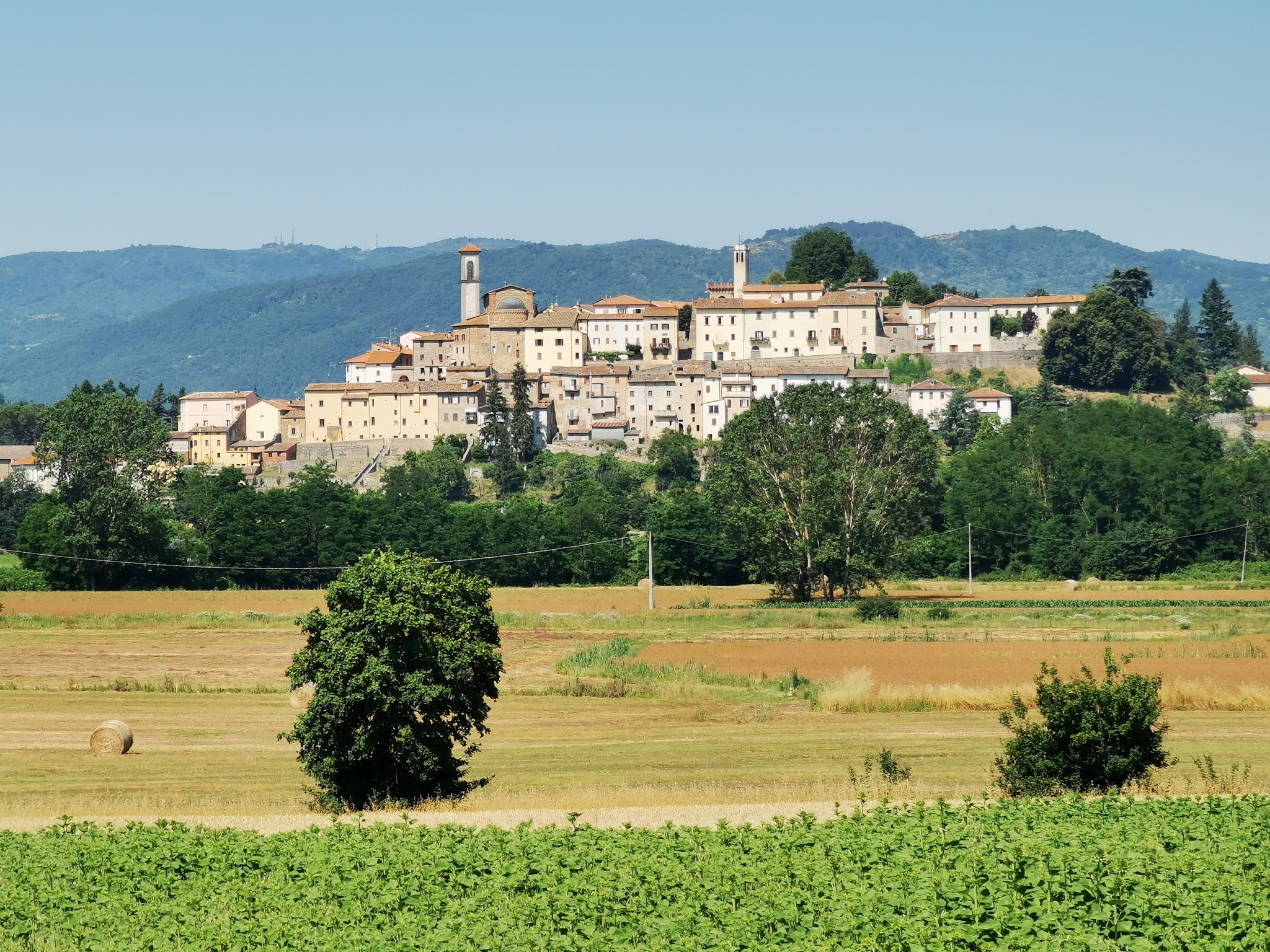


No comments:
Post a Comment