After coming back from Germany and spending a few days back home in Vicenza I decided to do another multi-day hike and opted to walk two pilgrimage ways in one go. I researched a few options and then picked the Cammino Celeste and the Romea Allemagna, two pilgrimages that take place in the region of Friuli Venezia Giulia, not far from where I live. The first, the Cammino Celeste starts from the town of Aquileia and ends on the mountain top sanctuary of Monte Lussari, while the second, the Romea Allemagna is part of a series of pilgrimage ways that start in Central Europe and end in Rome. The part which I was gonna walk would be the Italian leg of it and specifically from the Monte Lussari sanctuary all the way to the town of Portogruaro in Veneto. On a nice Thursday morning, I then headed from the beach town of Jesolo to the nearby train station of San Donà di Piave. From here I took a regional train and reached the station of Trieste Airport from where I would start my hike. A strange place to start a hike but the airport was actually close to a site that I had not seen since middle school and which I really wanted to visit again. So after getting off the train and crossing through the large airport parking lot, I reached the small town of Ronchi dei Legionari. Here I passed through the modern city center which didn't feature anything particularly nice. The town though is known for being the starting place of a squadron of legionnaires that in 1919, captained by the poet Gabriele D'Annunzio, tried to claim the city of Fiume, nowadays Rijeka in Croatia, which had been contested between Italy and the Kingdom of Serbs, Croats and Slovenes since the end of the war. As I left the city heading north, I decided to stop on the way at a supermarket to grab some food to eat immediately as a snack and some for later to have for lunch. Then continuing onwards I finally reached shortly after the site I had wished to see again after so many years: the Redipuglia War Memorial. I had in fact been here on a school trip back in middle school, and as I saw the pilgrimage way was passing not far from there I gladly decided to take a small detour and visit it again. The largest war memorial in Italy and one of the largest in the world, it holds the remains of around 100 thousand Italian soldiers killed during World War I in the battles that were fought in the Karst and Isonzo fronts not far from there. The memorial itself was built in 1938 during the Fascist period, as many others were, on a slopy hill overlooking the valley. It consists of 22 horizontal platforms of stone, arrayed in step-like progression hosting the remains of the soldiers in alphabetical order. Above the last step, a votive chapel is lined by two large mass graves holding the remains of about 60 thousand unknown soldiers, so nearly two-thirds of all those buried. As I walked up the memorial I reached a central porphyry tomb that holds the remains of Prince Emanuele Filiberto, Duke of Aosta who had led the army during the war, and after dying in 1931 asked to be buried among his men. Right behind are five other tombs which belong to other generals. At the center of the first horizontal platform is the tomb of the only woman buried there, that of Margherita Kaiser Parodi Orlando, a volunteer nurse who died in 1918 while assisting soldiers sick with Spanish flu. The way up the rest of the memorial was unfortunately blocked as maintenance work was being carried out and thus fenced off. I nonetheless admired the incredible complex and then after a minute of silence decided to continue on my hike. After a few minutes of walking, I reached the small town of Sagrado, which featured a tiny historic center now cut through by the main road. Just after the town I then crossed a bridge over the Isonzo river which at this point has a beautiful greenish-blue hue. The clouds that had been covering the sun up to this point making the weather and temperature very bearable eventually disappeared and the scorching august heat started to make itself felt. After a bit of walking among fields covered in vineyards, I then reached the town of Romans d'Isonzo. Here I walked through the city center and stopped to visit the town's main church, the Chiesa di Santa Maria Annunziata. Rebuilt in the Neoclassical style during the 18th century it features a nice bell tower which reminded me a lot of those in the area of the Dolomites. After leaving the town I passed through another one shortly after, Versa, before heading onwards through fields covered in sunflowers, at that moment laying downwards due to the late season and excessive heat. I also passed some strange-looking plants which I hadn't seen before and which I later found out was sorghum a plant that was abundant in Friuli and Veneto decades ago and which is now rarely planted as corn and wheat are much more profitable. I was now officially following the marked trail of the pilgrimage which features signposts with a little blue fish, an ancient early Christian symbol found in Aquileia and that became the mark of the pilgrimage. After walking a bit through pure countryside I reached the small town of Medea. Here the path, instead of keeping low and through the town, headed instead up the hill overlooking it. Covered in a thick forest it made the walk much bearable by shielding me from the sun. At the top of the hill, I then came across the small church of Sant'Antonio dating to the 18th century. Next to it I found a nice peaceful picnic table where I decided to stop and have the lunch which I had brought with me from the supermarket. After the break, I continued on along the hilltop and reached the Ara Pacis Mundi, a monument built in 1950 to honor the fallen of all wars and especially those of the second world war. From there, at about 140m above sea level, I also had a beautiful view of the surrounding landscape which consisted mostly of flat land and fields. From that spot I then continued on descending the hill, walking through the town of Borgnano and reaching once again flat land. I could clearly see in the distance the unmistakable light grey of the Julian Alps which I soon would reach in the next days. After a bit more walking I reached the town of Cormons which was supposed to be my stop for the day but I had not found accommodation and had to book a little further away. As I walked through the pretty city center I visited first the church of Santa Caterina, a nice neoclassical structure built during the 18th century. In front of it is the statue of the Holy Roman Emperor Maximilian I, as he was the one who forced the Count Leonardo of Gorizia to hand over to him the city and the rest of the county after his death in 1500. As I headed on I passed the nice Palazzo del Mestri from the 18th century and a little further reached the town's main square. Lined by nice colorful buildings and lively bars and restaurants it is not far from the main church, the Duomo of Sant'Adalberto. I tried to visit it but it was unfortunately closed so I had to settle with viewing the scenic staircase opening up in front of it. It was then time for me to finally go to the accommodation I had booked, another 30 minutes walk from there. On the way I stopped to admire the picturesque Centa di San Giovanni, a hamlet made up of typical stone houses which one formed their own fortified hamlet. Then after a whole 30km, I was finally in Brazzano where I had booked my Airbnb. The owner was there waiting for me and showed me to the nice apartment which was all for me. I first unpacked and had a nice warm shower and later bought some stuff from a nearby supermarket to cook for dinner. Finally, I was able to go sleep and rest for the second day of my hike.
The following morning after a nice early rise I was out and about already before 9am even though I did not have such a long way ahead of me. However, I intended to walk during the cooler hours and avoid the afternoon heat. After leaving the town of Brazzano, I soon was able to see the Julian Alps clear in the distance yet again. As I walked further the way started to become hillier, I was now entering the Collio area, a hilly area north of Gorizia, and leaving the flat lands behind. The wheat and corn fields now gave way to vineyards all over which makes the Collio area famous for its wines. Soon after I passed the Trussio castle, a 13th-century castle now turned into a restaurant. I was now walking among beautiful vineyards with incredible views all around me and the border with Slovenia just a few hundred meters to the east. I continued like that for several kilometers, enjoying the sun, which wasn't as hot yet, and the gorgeous landscape. The hills covered in green vineyards were a beautiful and stark contrast with the thick forest ahead and the form of the mountains in the distance. As I was walking I also noticed a few falcons hovering right above, probably hunting for small rodents hiding among the vines. At one point I came upon what seemed like two pilgrims walking in front of me, I caught up and asked if they were also walking along the Cammino Celeste. They responded that they did in fact, and we introduced ourselves; a woman from Piedmont and her husband from France. We walked a few minutes together and then as we approached the small town of Prepotto, we were now leaving the Province of Gorizia and entering that of Udine. In the small hamlet of Albana, right by Prepotto, we decided to stop at a restaurant I had been suggested by another pilgrim on social media. The place in question was the Agriturismo al Vecchio Gelso where we had a really tasty homemade lunch, a gnocchi as first course and a salad as second course. From there we then continued on along the way together and talked about past pilgrimages and maybe future ones in plan. I learned that the French man had walked for more than a month a pilgrimage way that cuts through Japan. After a bit of walking uphill and through the forest I saw the other two pilgrims had started slowing down a little so I thought they might have wanted to walk alone and I wished to walk a little further. So after waving them goodbye I sped up and continued on alone. After a few kilometers like this, I finally came out of the forest and in sight of the impressive Sanctuary of Castelmonte. More like a small fortified village made up of a central church surrounded by houses and stone walls, it was built at about 618m above sea level, on top of a hill overlooking the whole area. Probably started as a small chapel built inside the rock, the sanctuary was already prominent and prosperous during the 13th century and from then on grew and was rebuilt several times. Its present form dates to the 18th-century refurbishment which remade the whole church interior, while the facade and bell tower were remade in the 1930s. It is nowadays a popular pilgrimage site not only for the local population but also particularly for Slovenians, as two important manuscripts in that language were written here during the 15th century. The main devotion though is towards the statue of a Black Madonna kept on the main altar, to which the sanctuary is dedicated. As I walked through the narrow streets, I headed uphill and reached the church which I visited and stopped for a prayer. Right outside, a nice terrace was built which granted a beautiful view, spacing nearly all the way to the Adriatic Sea. Nearby, just below the church I then finally headed to my accommodation, the Casa del Pellegrino. This large building contained several rooms, mostly used during the holidays and specific dates when a large number of people come to the sanctuary. On that particular day, I was just one of the very few there and was then shown to my room by the kind lady working there. The view from my room was amazing, even better than from the terrace above. I unpacked, showered, and then relaxed a little on the bed. Then as I was once again gazing out of my window I soon saw the two pilgrims I had met earlier that day, just arriving at the sanctuary. I waved and yelled at them and then wave and yelled back and then were off, as they had told me they had booked a room in a B&B further outside. It was then time for dinner so I headed downstairs where the restaurant was located and I noticed it was just me and another 3 people. I had a tasty dish consisting of sausage, polenta, and broccoli, accompanied by a local beer. Then I was off to bed after about 22km with a large part uphill towards the end.
In the morning I woke up early as I had a long way ahead. I had a quick breakfast downstairs and then was off on my walk already before 8am. The day was gorgeous once again I could see clearly the mountains in the distance, every day closer and closer. I followed the road downhill and in just over one hour I reached the city of Cividale del Friuli, a suggested stop but which I decided to visit and head on instead to save time and distance for the following days. The city is known for having been founded by Julius Caesar as Forum Iulii, which then gave the name to the whole region of Friuli, and for being then under the Langobards one of its major cities between the 6th and 8th centuries. As I approached the city from the south I soon reached a nice vantage point just outside the city center which allowed me a perfect spot to admire it and photograph it. In fact, right in front of me, I could see the city center bordered by the Natisone river which forms a picturesque ravine. To reach the center I then crossed the 15th-century bridge known as the Ponte del Diavolo, or Devil's bridge. The legend states that as the locals weren't able to build a bridge in such a dangerous spot of the ravine, the devil built it for them in exchange for the soul of the first person to cross it once completed. The locals though used a ploy to trick the devil and made a dog pass once it was done, thus letting the devil leave without a man's soul. Once on the other side, I finally entered the city center and passed in front of the Palazzo Comunale, a gothic palace from the 16th century with the bronze statue of Julius Caesar standing in front of it. Right across the street from it was the Duomo which I proceeded then to visit. Featuring a simple facade and thick bell tower, the Cathedral was built around the 15th century in a Renaissance style. Its interior, quite simple as well, has a nice geometry to it and features some interesting objects such as the 13th-century Crucifix and the nice monument to the condottiere Marcantonio di Manzano. After the visit to the church, I then continued my walk through the city center, admiring the beautiful architecture, mostly medieval which makes the city famous among tourists. I passed by the so-called medieval house, a nice stone building dating to the 14th century and thus the oldest surviving in town. Not far from there, I then decided to visit the museum located inside the Monastery of Santa Maria in Valle, the main attraction in town. The monastery itself is made up of different parts which you could walk through as you entered the ticket office. I first passed through the church of San Giovanni, whose exterior shows a typical Romanesque style dating from the 13th and 14th centuries, while the interior was fully remade during the 18th century with Baroque decorations. Then on through the cloister featuring a mostly Renaissance style and partly closed to the public as it now holds some offices. Then finally to the main feature of the whole complex: the Tempietto Longobardo. This one-of-a-kind structure is an oratory dedicated to Mary and built around the 8th century by the Langobards who as mentioned ruled over most of Italy from the 6th to the 8th centuries. This is the most important and best-preserved example of Longobard architecture, which resembles styles found in Roman, Ottonian, and Carolingian art. The interior, quite small, featured some beautiful stuccos representing saints, with a clear byzantine influence, and other floral decorations and nice frescoes, some partly faded. The small oratory has been inscribed as a Unesco site in 2011 together with other sites around Italy symbolizing the power and administration of the Langobards. The place was a real jewel, and because of very few tourists around, I was able to admire it fully and for quite some time alone. Once back outside, I headed towards the exit by strolling through the little garden next to the oratory which granted a beautiful view over the Natisone River and that part of the city. From there I then headed to visit the Museo Cristiano e Tesoro del Duomo, a museum located right next to the Cathedral which holds ancient pieces from the Langobard and medieval periods. Inside were some beautiful marble friezes, decorations such as the Baptismal font that once used to be in the oratory I had just visited. It was built in 740 and is really well preserved featuring some interesting decorations on its octagonal structure. Then I also saw the Altar of the Duke Rachis, dating to 744 and made in marble it features religious scenes such as Christ in Majesty, the Visitation, and the Adoration of the Magi. These were just two among many other things such as golden crosses, paraments, and boxes featured in this nice small museum. After that I headed on to another museum, this time a much larger one, hosted inside the Palazzo Pretorio on the town's religious main square, Piazza Duomo. The palace itself dates to the end of the 16th century and has been attributed to the architect Palladio. It once served as the seat of the Venetian administration ruling over the town during that period. Nowadays the palace holds the National Archaeological Museum which is particularly known for its high medieval archaeology particularly that of the Langobard period. Inside I admired the experienced goldsmithing skills of the Longobards who created many interesting daily objects and jewelry, as well as the religious artifacts such as stone crosses, plutei, and other ornaments. In a room, there were also some nice ancient Roman mosaics found out below the street level around town in the last century. After the visit to the museum, I continued my walk around town, passing by the other main square, the more lively Piazza Paolo Diacono, where a lot of people were gathering for the daily stroll and starting their aperitivos at the many bars around it. I then passed in front of the nice church of Santi Pietro e Biagio which a wonderful frescoed facade and eventually exited the old town to the north. Here I decided to stop by a supermarket and grab some food as lunchtime was fast approaching. I also intended to buy food for dinner in two days as I was going to sleep at the top of the mountains without any town in kilometers and thus no way for me to get any food there. That meant that from then on to the following night I was carrying a few extra kilos consisting of carrots, tomatoes, apples, and canned beans, and tuna, all stuff I could keep outside of a fridge for long. Once I was packed and ready I left the supermarket and headed on northwards, leaving the town of Cividale and heading uphill through a nice thick forest. That helped me keep the heat of the sun away and in fact not long after I decided to take a break and eat my lunch in the refreshing shade. After eating I got back on my feet and continued forward, soon after leaving the woods and arriving at a nice open area where I could see the flat land I had left behind the day prior. After a series of parts through open land and woods, I then reached the last town for the day, the small village of Tamoris where I was able to refill my water bottle from a fresh fountain. The place did not seem lively, despite apparently listing 12 inhabitants, but I managed to spot a couple of old people just hanging about. From then on I was alone along the street walking through a beautiful landscape with the Julian Alps closer and closer and starkly shining under the sunlight of the later hours. After a bit of walking, I finally reached the Agriturismo Zaro, my accommodation for the night. This place, literally in the middle of nowhere surrounded by beautiful forests and just 1km from the Slovenian border, is owned by an Italian woman, her Slovenian husband, their two children, and the parents of him. Once I arrived I was warmly greeted and brought to where I would be sleeping: a little wooden hut on the margin of their land close to the forest. A bit messy it was at least warm but it didn't have a bathroom so that meant I had to walk across the field to where the owner's house was and there find the bathroom in their cellar. I took a shower then and unpacked my stuff and then hung out a bit before going to their small restaurant where they served me a tasty dinner: spinach pasta and polenta with frico, a type of warm cheese potato dish. After that, it was time for me to go to bed in my little hut after another long hike totaling 32km. Once there though I hardly managed to sleep as I had several moths who had decided to make the hut their home too and were buzzing about and hitting the wooden planks waking me at each second.
The day after eventually managing to fall asleep, I had breakfast at the place again and thanked the owners before setting off on my walk. After walking for a bit through a beautiful and peaceful forest I did a short stretch uphill and reached the small town of Prossenicco, made up of just 35 inhabitants. I walked through the tiny center, visiting the small main church and admiring the beautiful views of the surrounding forests. Then I continued on by following the path which took me again through the forest. I reached then a small bridge which crossed over the Natisone river, the same that then flows through Cividale, which at this point was shallow and narrow. Here was also the border between Italy and Slovenia and I took the chance to take a seat at the old guard's hut and have a quick snack from my backpack. A little further on I then decided to take another quick break and freshen up by swimming in the river. I found a nice sandy spot just by the shore where I took my clothes of, all of them, and dipped in the ice-cold waters of the river. That helped a lot to not feel the heat and also made my legs feel the fatigue much less. So after dressing up again I continued on and followed the path further soon after starting my long ascent which would never end. As I headed further up I then reached a nice spot where the forests ends and the stark bare white mountain begins. It is here that the Natisone river is born and it seems like a lunar landscape, eerie yet beautiful. After continuing onwards, still uphill, I finally reached the village of Montemaggiore, at about 790m above sea level, and inhabitants: 15. The official site of the pilgrimage way suggested to sleep here, however, I had not found any place available and so opted instead to head up the mountain and sleep at the refuge, which this year, due to the covid, was unattended and thus without electricity and running water. That is why I had bought food to take with me the day before and now I was nearly there. In Montemaggiorethough I decided to eat something for lunch as I found there was a restaurant which was open. Here a kind girl and her mother made me a tasty dish of gnocchi with ragu and a filling huge salad as a second course. After thanking the two women I then started my last scent, this time up the steep side of the mountain. Those 800m gain took me quite a while, tired as I was already, and with a much heavier backpack than usual, I needed to stop several times to catch my breath. On those occasions, though I took the chance to admire the beautiful panorama behind me which changed the further up I went. Finally, a couple of hours later I had reached the top of the Gran Monte at a whopping 1636m above sea level. From here I had a 360 degrees view of literally everything around me. To the south, the gentle hills covered in forests I had walked that day and the previous ones. Then the village of Monteaperta way down below me, looking like a miniature model in the distance. To the north and east the impressive view of the Julian Alps, mostly covered in clouds, but which I could sometimes make out the form of the largest and main ones of them, the Canin and the Monte Nero, all above 2000m. The panorama was incredible and I was there all alone to admire it. I barely had any internet throughout the day as most of the areas I had walked through were completely desolate and far from any major town. Up there however I managed to get a good signal and thus proceeded to call my girlfriend and then my parents to let them know all was good. After a bit standing up there and having the whole world below me, I decided it was time to head to my accommodation, which from here I could see located a few hundred meters down to the opposite side I came up from. After a few minutes of walking, I reached it, the mountain hut where I would be sleeping that night. This large barracks, once used during the war, has been turned into a mountain hut in recent years. Once there I noticed, luckily, that I was not alone and in fact met 5 other pilgrims, walking separately, who apparently were walking along the same way as I did. I had caught up though because I had joined 3 stages into 2 and thus was able to meet them there. We had all brought our own stuff up as the hut did not have any electricity nor running water, and certainly no food at all. In order to shower, I was able to get some leftover rainwater in the hut's tanks and sprinkle myself a little in the small prairie in front of the hut and quickly apply soap and rinse myself. Of course, the water was cold and not much so I had to make the best of it. After shaking from the cold I quickly changed into fresh clothes and then decided to have dinner, before it would be too late to see anything at all. I took out the food I brought with me and eat outside in the last rays of sun gleaming in the distance. Then as the sun set, the place became pitch dark so I decided to head to sleep like the rest of the pilgrims did, tired but satisfied after 25km and 1530m of ascent, the toughest day so far.
In the morning, I woke up as last as I did not wish to walk in the dark or in the cold, so I waited till all the other pilgrims had left and then prepared myself as well, leaving the hut behind me and descending the mountain on the opposite side I had come up from. I did well to wait, as I was heading downhill through the rocky terrain amidst the forest, due to the height the ground was still wet, and maybe it really hard not to slip and fall; it would have been much worse if I had left earlier still in the darkness. After about an hour I then reached the bottom of the valley, where the Passo di Tanamea is located. This pass, located at about 800m above the sea was the only moment I could walk on flat land for the rest of the day so I enjoyed it as long as I could. At one point I had to start climbing again, and quite steeply as well. Despite being under the cover of the forest the past day had made my legs feel more tired than usual and thus I needed a few breaks as I went up and up. After a while, I came out of the forest and to another mountain hut, much smaller in comparison to the one I had slept in the night before. Called the Casera Nischiuarch, it looked like the typical stone huts herders use during the summer as their accommodation when taking their herds to feed on the fresh grass. The place was empty inside and I doubt anyone had slept in it, probably preferring the larger one where I and the other 5 pilgrims had stayed in as well. From the hut, I then followed the path which gradually headed downhill making it much softer and easier on my legs and knees, eventually bringing down the other side to yet another valley, the Valle Uccea. Once out of the forest, I then reached a small isolated church, the Chiesetta di Sant'Anna di Carnizza, built during the 19th century. Right below the church was a series of curious constructions, like small huts that I learned, were used in the past by the herders who came to the area for a few months during the summer and stayed in before heading back to the plains for the winter. They are now mostly abandoned while some have been turned into holiday homes. I continued on, following the road heading downhill until I reached a point where a signpost pointed at a small deviation. I obviously took it and in a few minutes reached one of the most beautiful spots so far. The Fontanone Barman is a gorgeous waterfall set among high rocky cliffs and with an impressive 70m drop. The crystal clear waters, which come directly from the peaks above, form a peaceful and inviting small pond which I decided to take a swim in. The waters were absolutely freezing and I wasn't able to stay in with my legs for long because of all the walking I had done with them the cold felt strangely cold and hot at the same time. I was the only one there so I decided to set up camp and have my lunch, the leftovers from the previous night, and enjoy the beautiful scenery. After a couple of swims, and drying in the warm sun in between, I then decided it was time to pack and leave. Heading down from the waterfall I then reached the street once again and followed it for a while until I was nearly in sight of the town where I would sleep that night. I first walked through the small hamlets of Lischiazze and Gniva, which are set on the narrow valley that then joins the larger Val Resia. This valley which extends east-west is bordered to the east by the impressive figure of the Monte Canin which also marks the border with Slovenia and is surrounded to the north and south by a chain of mountains. The Resia river flows through it, giving its form and name. As I crossed the river, over the bridge, I noticed how below me there were several locals who had set up umbrellas and seats and were enjoying the sun by laying next to the river bed. Some kids were also having fun by splashing in the water and jumping from some high rocks above it. The water looked beautiful, with its greenish crystal clear color, and very inviting, but I was tired and nearly at the end of the hike for that day, so I decided to push on and finish the last few hundred meters with a sprint. Finally, after a short climb, I had reached the small town of Prato di Resia where I would be spending the night. I had booked a room in the building where the Natural Park of the Julian Prealps is based; in fact above the office, where I checked in, they have a few rooms, all very modern and super clean. I was assigned to one of the rooms which, for just 20 euros, had probably one of the most beautiful views I ever had from a room window. After thanking the lady, unpacking, and showering, I figured out that one of the 5 pilgrims I had met the night before was also staying there. After introducing ourselves we talked for a bit about past and possible future hikes and then planned to meet up later to have dinner at one of the local restaurants. In the meantime, I took the chance to take a seat out on the balcony and read my ebook while having a dramatic scenery as a backdrop. I must have dozed off for a bit because I then woke up to the other pilgrim, Patrick, knocking on my door. After getting ready we headed out and walked to the restaurant Bar Alle Alpi, where we met up with the other 4 pilgrims who had decided to sleep in the hotel annexed to the restaurant. We had dinner all together sharing stories about our lives and past walks, and making comments on this walk so far, and on possible tips for the days to come. Then after the tasty dinner, we were all off to our respective beds, after another hike up and down the valleys, for a total of 23km and 703m of ascent and 1711 of descent.
In the morning, I woke up again later than the other pilgrims, some of which I heard had decided to wake as early as 5 or 6 am, preferring to arrive really early to their next accommodation. I did not wish to do so because I had no rush to get to my next destination, and I rather wished to enjoy the day as it went, having then more time to admire the nature around me than reach the next place and then stay there and do nothing. Once I got up, at around 7am, I, unfortunately, noticed that it was quite cloudy and was hoping no rain would come. After leaving my accommodation, I walked along the road that led, yet again uphill, and left Resia well behind me as I vaulted over another mountain, this time much lower than the ones on the previous two days. I reached the top, at the Sella Sagata, where a small church was set, and from there headed back downhill on the opposite side. The way was nice at first, winding its way through a calm and lulling forest. Then, the way got steeper and with more rocks, until I reached a point where I could see the next valley, the Canal del Ferro. This long deep valley would be ever-present for the next few days, as I would first walk part of it heading north, and from my final destination of this part of this pilgrimage, I would then walk it again, fully, heading south. So from this point, I could now see the first town, Chiusaforte, right down below me, and which I reached after a few minutes walking down the path. Once I reached the town, I noticed it is formed by two parts, on either side of the Fella river. I first walked through the eastern part which forms a town by itself called Raccolana. The architecture though was mostly modern as the town was hit harshly during the 1976 earthquake that hit most of Friuli. Large panels were set along the city streets showing how the town looked like before. It must have been really picturesque as the photos showed the typical stone architecture which can be still found in some of the other towns around the area. Then, as I crossed the river, I reached Chiusaforte proper. I decided not to visit it now, as I would anyways have to pass here in three days time. However, I still stopped at a local grocery store as I needed to eat something and had to plan to take lunch with me as I would again be in the middle of nowhere by then. I stopped at the Alimentari Buteghe, which I would then again visit three days from now, and bought some fruit, vegetables, and bread, cheese and salami for later. Then I was off heading northwards along the narrow valley, which at this point was quite unappealing due to the highway passing really close to the path I was walking along. The same path I was walking along would be the one I would then walk down following the other pilgrimage way, the Romea Allemagna. It was rather boring as it was mostly on cement, along a bike path, and with hardly any change in scenery. At one point I passed by a nice waterfall, the Cascata di Cadramazzo, and stopped for a quick photo. Then I was off continuing onwards, oftentimes, having to step to the side because cyclists, mostly coming down from Austria or Germany, were using the way along the Alpe Adria bicycle route which connects the Alps to the Adriatic Sea. Not long after I then reached Dogna, another town along the valley. Here, instead of heading on straight north, I turned into another valley, the Val Dogna, a remote valley heading east, with hardly any cars or people. In fact, along the whole five hours which took me to walk it, I probably counted a total of 5 cars. As I started the progressive ascent of it I noticed in the distance the figure of the Jôf di Montasio, the beautiful ever-present mountain which would be the main backdrop of the valley until the end of my walk that day. At this point, it was still gloomy and thus covered in clouds but i took some pictures anyway, finding it a mesmerizing sight. The road which I was now following along the valley was a road that was built during World War I when the Italian army tried to flank the Austro Hungarian. In fact, the Austrians did not expect the Italians to head up this rugged valley and thus had it very poorly defended, thinking instead the troops to be coming up from the more used Canal del Ferro. As I continued on, I passed by some really strange named hamlets such as Chiutdipupe, or Chiutzuquin, which to me would have fit for some ancient Aztec locations in Mexico. There are apparently some people still living here, despite the remoteness of the valley and the earthquake that hit in 1976, however, as I was there, they all seemed rather desolate. Luckily, in each one of them I was able to refill my bottle, much needed as now the sun had started to peer through the clouds and the temperature was beginning to rise. Walking along the asphalt road did not help and there was barely any tree cover to be had. After a bit of walking with no sight of cars nor people, I reached a small rest area where a picnic table was set among the ruins of some stone buildings from the first world war. I sat there and had my lunch while admiring the view of the Jôf di Montasio, sharply jutting out in front of me. After eating, I was back on track and continuing onwards towards my destination. Soon after I passed by the Pian dei Spadovai, an open pasture area where some cows were grazing next to two farmhouses. I had tried to book accommodation here but was, unfortunately, told it was full. To my surprise, I found one of the five pilgrims had managed to book it and was already there enjoying lunch and rest. I waved at him and after a brief conversation bid him farewell, continuing onwards, there were still a few kilometers for me to go. After a few bends, obviously uphill, I turned around and admire the beautiful valley which I had just walked up. The clouds still present, and few rays of sunshine peering through made it dreamlike, but soon a thunder in the distance woke me from the peacefulness and prompted me to speed up the pace. A few minutes later though I started feeling some drops so I quickly grabbed and wore my poncho. In fact, just a few seconds later it was pouring; there was nowhere to hide as there were barely any trees so I decided to just head on with my gaze down to the street. As fast as it came the rain then stopped and I quickly remove the poncho, as it was too hot with it on. After a bit more walking I then reached the highest spot that day, the Sella Somdogna. I was now at about 1400m above sea level, and the road ended abruptly there. It was here that during the war, the two sides had fought, and the Italians able to outflank the Austro-Hungarian army. The view was incredible with high rugged mountains as far as the eye could see. A few minutes more then finally took me to my accommodation for the night, the Rifugio Fratelli Grego, a nice wooden mountain hut right below the Jôf di Montasio. This time it had all the commodities, including hot water and food from the restaurant downstairs. As I arrived I noticed two of the pilgrims were here as well, Patrick, the one who slept in the same place as me in Resia, and another one from Padova. Before heading up to the room, I admired the beautiful view: mountain peaks everywhere. In the distance, I was even able to see the outline of tomorrow's destination, the Monte Lussari Sanctuary, also the end of this part of the pilgrimage. But that was for the next day, so I decided to head inside, shower, and change into fresh clothes. The two pilgrims and I then had dinner together: we were the only guests there, so the owner talked with us for a while, describing then the peaks which could be seen from there. We had a tasty meal consisting of polenta, frico, and goulash, accompanied by a nice refreshing beer. Then we were off to bed, tired after another long hike, this time totaling 32km and mostly uphill.
The following day I woke up really early, at about 5am, and quickly headed out in the cold to take some beautiful pictures of the sunrise shining the mountains. Then I went back to bed and got up again at 7am, right after the other two pilgrims. The sun was now higher and much warmer and I took the chance for more pictures. Then I was off, for my last day on the Cammino Celeste pilgrimage, heading down the path in the direction of the Monte Lussari. The way down was not easy as it was quite steep and the ground still wet making it rather easy to slip. Once I had reached the bottom though, the way became then much more relaxing for several kilometers. I had now reached the Val Saisera, a nice north-south facing valley narrowly situated between high mountains. Turning around from where I came in fact, I noticed the beautiful glistening face of the Jôf di Montasio, which with the morning sunlight, contrasted sharply with the blue sky. It reminded me a lot of the dolomites and I wished I could've stayed all day to admire it, however, I still had several hours ahead of me and so I continued along the path. The path then turned into a street which luckily did not see nearly any car as I walked alongside it. After a bit of walking, I then reached the Austro Hungarian Military Cemetery of Valbruna, a peaceful cemetery set among beautiful scenery. It was built in 1916 to holds the remains of those fallen so far, and those to fall in the coming years of the war. It features a nice wooden central hut and all around it the graves of the soldiers set among the grass. After a few moments there I then continued along the street and not long after reached the small pretty town of Valbruna. It featured some nice wooden houses with balconies decorated with flowers, such as can be found in the rest of the Alpine region, and seemed a nice spot to spend one's vacations and relax. I on the other hand had to go on though, so I continued along the way and soon after reached another town, Camporosso. From here I was now clearly able to see my destination, the Sanctuary at the top of the Monte Lussari, high above me. Before heading up though I decided to stop at a supermarket and grab some food to have later for lunch. I found one not far and grab some stuff to take with me. Then I started the ascent of the mountain and the last push towards the goal. I was starting at about 800m above sea level and needed to reach 1790m, so quite a big elevation gain. As I reached the start of the trail, a signpost marked the time to reach the peak would be about 2h 30, so I decided to take it slow and steady in order to reach it without too much effort. As I walked uphill along the path though I strangely did not feel the tiredness anymore and my pace seemed to be very quick and steady, as I went, I passed by many people attempting to hike to the top, both young and old, all well behind me as I sped past them. Eventually, after just about 1h 20 I had reached the top. I was so surprised about myself, and quite proud of it too; I had walked a whole seven days up to that point and with the 17km of that day, a total of 181km, including some huge elevation gains; and with that, I managed to walk the last stretch in nearly half of the time indicated by the signpost. Once on the top, I could now see the Sanctuary in front of me and all around a beautiful 360 degrees view of so many different mountain ranges; no wonder the place is called the balcony of the Julian Alps. I then decided to head into the church itself and visit it before heading to my accommodation. A first chapel was built on the spot in 1360 after a shepherd had found a statue of the Madonna while leading his sheep to graze. The chapel was then later substituted by a church during the 16th century which then later suffered damages and transformations, particularly after a thunder hit it during the 19th century, and during WWI when it was heavily damaged. The importance of the Sanctuary though is that it serves three different communities, the Italian, Slovenian and Austrian ones, and has done so since the start. In fact, all three populations come here to show their devotion to the Madonna, and inside the church are all signs of this devotion in three different languages. As I sat down inside I noticed that my pilgrim friend, Patrick, was there as well, so I sat with him and we stayed there for a bit while experiencing the strange but interesting mass carried out in the three languages. After mass, I went out of the church and had my lunch while sitting on a stone wall and admiring the view from there, then I headed down some steps and into one of the 10 or so buildings that make up the little hamlet around the sanctuary. I had booked a room in the accommodation, and so did my friend Patrick, as all other accommodations were either closed or being renewed. We were shown to our rooms, which looked nice and clean, and from my window, I had a really nice view of the mountains. After showering and changing into new clothes, I relaxed a little and then headed out once again to admire the panorama before sundown. A great thing about spending the night up there was that all day hikers, tourists, and even the workers of the small shops, were going to leave at about 6pm when the last gondola lift would take them down to Camporosso. I took then the chance then to have the whole place for myself, walking around without any bother and admiring the incredible view around me. It was then time for dinner and the other pilgrim and I headed downstairs from our rooms where a kind cook from Morocco, working at our accommodation and sleeping there as well, made us a tasty dinner. Then it was time for bed, now tired and feeling all the kilometers so far.
The next day I woke up a little later and had breakfast with Patrick. He had finished his walk and was going to take a bus later in the morning back home. I on the other hand was ready to start my second part of the hike and walk back southwards along the Romea Allemagna. As soon as the first gondola lift left, my friend waved goodbye and headed down to Camporosso to catch his bus, while I headed walking down some fields which in winter are used as ski slopes. It was unfortunately cloudy again, and would be so for most of the day; that was bad enough not to enjoy the panorama but at least I was not hot. After reaching Camporosso, I walked through the pretty town center and visited the main parish church built in a Gothic style but with the interior remade in the Baroque style during the 18th century. Further on I then entered another church, the Chiesa di Santa Dorotea, originally dating to the 11th century. Inside were some nice medieval frescos, some partly being restored and covered in scaffolding. Once outside, I then continued on along the way, following now the new brown signpost of the Romea Strata, here called Romea Allemagna. A few kilometers later I reached the small town of Ugovizza where I walked through the pretty city center and visited the main church, the Chiesa dei Santi Filippo e Giacomo. Featuring a Neoclassical style its Gothic bell tower had to be reconstructed following a mudslide that completely destroyed in 2003. From the town, I then continued along the pilgrimage path, which for the most part coincides with the Alpe Adria bicycle path. Despite the asphalt under my feet, the views were incredible and I passed a part of the Val Canale valley which was too beautiful not to be mesmerized by it. The fields next to the path were green and verdant and here and there some typical wooden huts would dot the landscape and behind the imposing mountains partly covered by clouds. Not long after I crossed the river Sella, which flows throughout the valley, and reached the small town of Malborghetto, which featured a characteristic and picturesque city center with colorful houses and old buildings. I walked through the town, visited the main church, the Chiesa Della Visitazione di Maria, and right in front the beautiful so-called Palazzo Veneziano. Despite the name, it was not built by the Republic of Venice but rather in an Italian style which contrasted with the rest of the Germanic architecture of the town. Built during the 16th century it features a beautiful Renaissance structure with an elegant facade and a loggia in the back. It is now used as the town's Ethnographic museum. After leaving the town and heading further, I crossed the river once more and joined back the bicycle path for a while. Then I saw a nice spot along the river where I stopped and decided to take a swim and freshen up as the sun started peering through the clouds making it quite hot again. The waters were ice cold but of a beautiful green-blue hue. After a few dips, I got out, put back my clothes, and got back to walking. the way continued along the bicycle path, always sided by the river and down the valley, with a nice panorama of mountains and forests all around. Often times I would spot the highway on the other side of the river, but luckily the noise of the cars was not so present. After a few kilometers, I was nearly arrived in Pontebba, the final point of the day. However, just as I was reaching the town, a violent storm suddenly appeared and it started pouring. I managed to find shelter right below the highway pillars and so did some other cyclists which were just passing by. As fast as it came it then left, but the clouds were still lingering so I decided to speed up a little to reach my destination. I was now finally in Pontebba and decided to visit the church of San Giovanni Battista as I was passing right by it. Then I continued on and crossed the bridge that spans the Potebbana river which divides the town in two. Once, the river used to serve as the border between the Republic of Venice and Austria, then also between Italy and Austria Hungary, and ceased that role only in 1919 when after the war the territory became part of Italy. Two stone pillars stand on opposite ends of the bridge marking that border and that history. I then continued on through the city passing by the nice early 20th-century town hall and then ending up where the church, Pieve di Santa Maria Maggiore is located. This beautiful Gothic church dates from the early 16th century and features an impressive gothic wooden altar, easily found in Austria and Germany, but quite a rarity in Italy. After the visit to the church, it was time to head to my accommodation; I walked back through town and finally reached the Albergo Salus, a quaint little hotel which I luckily managed to book after receiving many negative answers when looking a few days before. A kind lady, the owner, showed me to my room, which was small but nice with the typical interior of an Italian house from the 80s-90s. After unpacking and showering I decided to head back into town to grab some food for dinner, then I went back to my room and ate there feeling too tired to go out and eat at a restaurant. After dinner, I decided to go to bed early after 31km and 1300m of descent.
The following day I woke up a little worried as it had rained and thundered all night. I was hoping not to get caught on my walk that day, especially as I would be walking without any kind of tree cover for most of the day. I left the town of Pontebba and headed south along the Alpe Adria bicycle path, which runs down the Canal del Ferro valley. Despite the change in the mountain peaks as I headed on, the way felt quite monotonous, cloudy as it was and along the same asphalt bicycle track, stuck in a narrow valley and with the highway often passing right next to or above me. After a few kilometers, I passed by Dogna, the same town where I had turned a couple of days earlier in order to walk up the Dogna valley. I continued on still keeping on the same path and not much later reached Chiusaforte again, here I decided to grab some food from the same grocery store I did a few days back. The owner recognized me, and after my purchase added a complimentary fruit to thank me and wish me good luck on my pilgrimage. As I did not have the chance the last time I was here, I decided to walk through town and visit its nice small city center. At its center, on a hilltop, stands the nice Neoclassical, Chiesa di San Bartolomeo Apostolo, built during the mid 19th century. As I left the town I then continued along the path, and for a few kilometers did not encounter any hamlet or town until I reached Resiutta. This small town had been a suggested stop on the official guide, however, I had looked everywhere and called all possible accommodations and had not managed to find anything. Neither was able to find anything in the nearby towns, nor in the next kilometers, and was only able to find a place in Gemona, more than 20km away. I had now walked already just above 20km: it was going to be a long day. The town of Resiutta lies at the beginning of the Val Resia, where the Resia river joins the larger Fella river in the Canal del Ferro. Right next to the rivers is a nice small cave-like structure which I visited that was once used as an icehouse to store the beer produced by the local population. After that, I continued on and then a few kilometers later found one of the tunnels ahead was closed so the bicycle path was diverted on the other side of the river. I crossed the bridge and passed by the town of Moggio Udinese, famous for its monastery, the Abbazia di San Gallo. Located on a hilltop, and a little further away from town, I, unfortunately, had to chose not to visit it as that day I would have many more kilometers to go, and such a deviation would have made a tiring day even more tiring. Continuing on, a few minutes later, I found what looked like a nice spot along the river, where two people were relaxing on the riverside. I headed down, dropped my bag, took off my clothes, and jumped in the ice-cold but crystal clear waters. That really helped as the sun had decided to shyly show itself again and it was thus getting hotter. My legs also thanked that sudden freshness and I was able to continue onwards without feeling any pain or tiredness for a while. Suddenly though as I was continuing along the marked way, some fences blocked my progress in front of a tunnel. The tunnel had in fact partly crumbled and so the local administration had decided to fence the area off. There was no way around, to one side the river and to the other the tall rocky side of the mountain. I did not intend to walk all the way back to Moggio, cross the river and probably waste more than an hour and who knows how many extra kilometers, so I tried to find a way through instead. Luckily I managed to find part of the fence that was bent (probably by someone who had thought to do the same as I did) and was able to continue on ahead. After a bit of walking, I then reached another bridge where I was able to cross the Fella river once again; the river was very wide here as it is the point where it joins the larger Tagliamento which then eventually flows into the Adriatic Sea. Then, I walked along the main street that took me through the small town of Carnia and to the next town, Portis. The town was, together with most other towns in the area, badly hit by the 1976 earthquake, and a new town built a few hundred meters from it slightly uphill. The old town was left there as it was and nowadays looks like a ghost town with crumbling buildings. Around it are some panels, put up by an international school called SERM Academy which uses the area to study earthquakes and as a base for training and response to calamities. One of the few remaining buildings in town, which was actually rebuilt due to its historical value, is the nice Gothic church of Santa Lucia dating to the 14th century. The interior was closed but I was able to see something by peering through the small windows next to the main door. A little bit further I then reached the town of Venzone, which I had visited a few years back with my parents, in the winter. I nonetheless decided to walk through it admire the beautiful medieval city center it holds. The town was nearly completely destroyed in the 1976 earthquake but was rebuilt with the same stones to look as it once had. I visited the Cathedral again and then headed out through one of the town gates which are part of the wall that fully encloses the old town. In the outskirts I then reached the small church of Santi Giacomo e Anna built in a Gothic style during the 14th century; destroyed by the earthquake it was the first religious building in Venzone to rebuilt. Like the church in Portis, it was closed but I managed to see its interior by looking through the small side windows. After seeing the church I headed back to follow the trail and walked for a while until i reached the small town of Ospedaletto; from here it was just a couple kilometers in a straight line to reach Gemona del Friuli. However, suddenly the clouds grew denser and a storm hit violently forcing me to quickly pull out my poncho. I carried on despite the weather and soon after entered the town of Gemona del Friuli, which I had also visited with my parents years before. I walked through the pretty city center and decided to visit its beautiful Duomo once again. Built in a mix of Romanesque and Gothic between the 13th and 14th centuries, it features a splendid facade with statues adorning it and a large rose window. Badly hit by the earthquake it was built completely with the same stones that had been numbered in order to put them back in the right place. It was now time to finally head to my accommodation, which to my dismay, was still another half hour away, on the outskirts of town. I left then the city center and walked in the direction of the B&B Al Ciclista, the place I had booked for the night. Once there I rang the bell and the two owners, an older couple, let me inside. After telling them I had walked for 54km from Pontebba, and seeing I was drenched by the rain they helped me get my stuff off and showed me to my room. After a nice shower and a change of clothes, they called me downstairs where we had dinner together. They were really friendly and very interested in my walk. In fact, they were avid bicycle fans, hence the name of their B&B, and were hoping once to do a long-distance walk like me. After talking and eating abundantly I thanked them and headed to sleep, tired after the most distance I had ever walked in a single day.
The morning after, I rose up early, before 7am, and had a lovely breakfast prepared by the owners. As I was eating, one of their geese and one of their roosters came to see what I was up to and observed me until I was done. Then I got my stuff, thanked the owners for a lovely place and tasty dinner and breakfast, and started the day's hike. Finally, the sun had decided to shine bright again, and a nice fresh wind was blowing from the nearby mountains to the north making it a perfect temperature for the walk. I passed by some fields before reaching then the hilltop overlooking the town of Osoppo. I walked to the top and reached the Osoppo fort, an important defensive structure both during the time of the Republic of Venice and during WWI. The fort is located at about 330m above sea level and dominates its surroundings, thus its importance as a defensive structure. To the west lies the Tagliamento river while on the other three sides a flat countryside. The view was beautiful and I took the chance of exploring the ruins of the fort which expands all around the hilltop. Due to its proximity to the area hit by the earthquake, the fort and the town below were also badly hit and thus mostly showcasing ruins. There was the structure of the church of San Pietro, which in an attempt to show the destruction of the earthquake was left without a rooftop and covered with a simple metal arch. From the fort, I then walked down through the town and headed southwards, following the pathway. Soon after the path entered a nice forest close to the river, it is a protected site and shows how once such a forest used to cover the whole countryside here before being turned into tillable fields. After the forest, I continued through more countryside for a while until the path joined a trafficked road. Here I found a supermarket and took the chance to buy some food to have later for lunch. After getting the grocery I continued onwards and reached the small town of San Tomaso, part of the municipality of Majano. Here I visited the beautiful Ospitale di San Giovanni, a medieval hospital founded by the Knights Hospitaller during the 12th century as a refuge and point to get some food for pilgrims on the road from the Baltic to Rome. I had planned to stay there that night, as it was a suggested stop and would have been quite apt for my case as a pilgrim to be in such a historical place, however, it was unfortunately closed and that meant I had picked another town where to sleep, merging again two stages into one. The church annexed to the building though was open so I headed inside to visit it. A simple building with a single nave, its exterior features some nice painted frescos, while the interior holds some traces of frescos and a nice wooden gilded altar. It was then time for lunch so I decided to sit right outside the church, under the shade of a tree, and eat the stuff I had previously bought at the supermarket. Once I was done, I was off following the road again. At this point though I decided to take a small deviation and visit the nearby town of San Daniele del Friuli, famous for its tasty dry-cured ham. Once there I entered the old town by passing under the northern city gate, the Porta Gemona, designed by the architect Palladio in 1579 by using a preexisting medieval tower. I then walked through the picturesque streets, and admiring the local architecture, and ended up at the Parco del Castello, a nice park located where the castle used to be once. Despite the castle not exiting anymore, there is still a nice church, the Chiesa di San Daniele in Castello, which features a mix of Gothic and Renaissance architecture. The view from there was amazing and space out to the surrounding countryside as the town sits on a solitary hilltop. I then headed back through the city center, passing by a nice building known as the Casa del Trecento, a medieval stone house from the 14th century which survived the bombings of the second world war and the earthquake of 1976. Not far from the house I then entered the church of Santa Maria Della Fratta, a Gothic church from the 14th century with a baroque main altar inside, and a medieval fresco depicting a hunting scene. Back the way I came I then walked to the main square where the main church, the Duomo, and the 15th-century town hall are located. I entered the Duomo which featured an impressive Baroque facade designed in the early 18th century by the famous Venetian architect Domenico Rossi. The interior, also baroque, was rather simple and typical of that architectural style. Once outside again it was time to head on, so I left the town heading northwards and rejoining the official pilgrimage path. A few minutes later I then reached the small but pretty Lago di Ragogna, a lake of glacial origin. Along its shore, I found a small wooden watchtower which I climbed to better admire the view. Once up the top, I was able to have a beautiful sight of the lake below and the mountains in the distance as if they were encircling the lake itself. Once back down from the tower I continued on and a couple of kilometers later reached the town of Ragogna, a municipality made up of smaller hamlets. In the hamlet of San Pietro di Ragogna, I reached the historical Castello di Ragogna, a medieval castle that has stood in that spot since the 10th century. In fact, the castle stands at the western edge of a large hill that sits solitary next to the Tagliamento river and surrounded by flat land, making it a strategically important site. Once I got to the top I had an incredible view of the river below and the mountains as background. Here was also the main keep, which I proceeded to visit and which held a nice small museum detailing the geography of the surrounding landscape. Right below the keep I then visited the castle church, the Pieve di San Pietro in Castello. Inside were the ruins of an older church that stood in that place and dating to the 11th century and some frescos from the 13th century. From the castle, I then headed back down to the town and continued on along the way. Right after I then crossed the bridge that spans the Tagliamento river in this area. As I crossed I also had a beautiful view of the unusual banks of this river, which is considered the wildest of Italy, meaning it still retains its original form and was not changed by human interaction. The river in fact presented several bends one after the other and was dotted by trees and rocks along its central flow, to the sides, high walls with forests nearly reaching the water. Ont the side of Ragogna I saw several people who were enjoying the sun and the fresh water on some small beaches that had formed by the river's flow. Once I got to the other side I then passed through the small town of Pinzano al Tagliamento, which is located just below the low mountains of this area of Friuli. The territory then slowly degraded into low hills mostly covered by forests and soon after turned into flatter land covered in fields and vineyards. I was now finally in the small town of Valeriano, where I would be spending the night, after another tough hike of 40km. I had booked a room in a winery that also functioned as B&B, and after being shown to my room, took a nice shower and changed into fresh clothes. For dinner, I decided to eat at one of the local restaurants and found a nice and lively one called Don Chisciotte. Here I ordered frico with polenta, a mix of grilled meat and grilled veggies as well, together with a beer. I noticed too late I had ordered too much, but eventually, I managed to eat everything despite being completely full after. After dinner, it was time to head back to my accommodation and finally sleep.
The next day, after another early rise, I left the town of Valeriano heading south. I passed through the typical countryside of the plains, made up of wheat, corn, and soy fields, with a few sorghum ones here and there as well. Then I passed by the nice church of San Marco in the small hamlet of Gaio in Baseglia. It featured a facade with a fresco and a nice 15th century portal with the lion of St Mark's at its top. As I continued further, I walked then to the next town, Baseglia where I came upon another church, the Chiesa di Santa Croce. A mass was just getting started and I quickly entered to admire its interior. The apse featured a beautiful cycle of frescos by Pomponio Amalteo depicting the stories of the cross. Before disturbing any further I then left the church and continued onwards, reaching shortly after the town of Spilimbergo. The town has a really picturesque city center made up of mostly medieval and renaissance buildings. As I walked through the old town I noticed they were setting up some stalls for some kind of medieval fair, which fit really well with the city's architecture. I passed under the Torre Orientale, one of the medieval gates of the second set of walls that encircle the city, and reached the central Piazza Duomo. To the south, as the name suggests, is the beautiful Duomo, an example of Romanesque and Gothic structure dating between the 13th and 14th centuries. The main entrance is not where the facade is, but rather on the side facing the square, which also featured a beautiful portal by Zenone da Campion from 1376. The interior was nice and well decorated with a Renaissance organ and several medieval frescos on the walls here and there. There was also a crypt below the apse which I visited and contained the tomb of the lord of Spilimbergo, Walterpertoldo, from 1382. After leaving the church, I then headed on to the eastern edge of the main square, where the castle is located. Originally built during the 11th century, it was later transformed and modified. It now consists of four palaces joined together but featuring different styles. The main and most beautiful, the so-called Palazzo Dipinto, which also hosted Emperor Charles V in 1532, Bona Sforza, Queen of Poland in 1566, and also Henry III king of France in 1574, features a beautifully frescoed facade and a style which is a mix of Gothic and Renaissance. From the castle courtyard, I headed back into town and walked a little further to reach the northern part where the Palazzo Degli Spilimbergo di Sopra is located. This beautiful 16th-century palace is nowadays the city's town hall and has a terraced garden with an incredible view of the surrounding landscape and mountains in the background. From there I could even see the town of San Daniele del Friuli and the castle of Ragogna which I had seen the previous day. After admiring the view for a while, I then headed back through the old town once more to take in the sight of its beautiful architecture once more. Then I left the city center and found a supermarket where I decided to buy some stuff to eat later for lunch. From there I continued further south along the way soon after reaching a small river, the Cosa, which I had to cross. The way across was easy as there was barely any water among the mostly rocky bed. I found though a spot where the river created a little deeper pool which I took the chance to plunge in and refresh myself for a while from the heat. After that i then continued on along the way, passing by the typical crop fields and vineyards and walking through some small minor hamlets for a few kilometers. After a bit, I then arrived in the next historic town, Valvasone. This small town is inscribed in the list of the most beautiful villages in Italy and is a true medieval gem. I walked under the northern medieval tower gate and reached the central square, Piazza Castello. On one side of the square is a nice old well, while at the center stands a large tree; all around it are a mix of various old buildings some of which with frescoed facades. The square is then closed to the east by the beautiful renaissance castle, originally built during the 13th century, but renewed a couple of centuries after in its current form as a palace rather than a purely defensive structure. The castle could be visited on specific days however as I was there, it was unfortunately closed. I decided then to find a bench somewhere and eat the lunch I was carrying in my backpack. Then after I was done, I walked through the rest of the old town, stopping by to visit the nice Duomo, featuring a neogothic exterior but an original gothic interior. I then left the town heading still south, and after a bit of calm countryside reached the next town: Casarsa della Delizia. A rather modern town with nothing particularly historical or interesting it is known though for the famous director Pier Paolo Pasolini who live here for some years of his life. He was also buried here and a study center has been built in town to continue and promote his work. As I left the town and continued further I passed yet more fields, and after a few kilometers eventually reached the next town, San Vito al Tagliamento. I had planned to stop here for the night as my friend from university period lives in the area. Before heading to my friend's house I took the chance to explore the nice city center of San Vito al Tagliamento. As I approached the town from the north, I passed by and visited the nice Monastero Della Visitazione di Santa Maria, a baroque monastery still inhabited by nuns. From there I then entered the old town proper, by passing under the eastern city gate, the medieval Torre Scaramuccia. It is part of the defensive walls that are still intact in some parts of the city and sided by a small canal that served as a moat. Through it, I then reached the large and beautiful central square, Piazza del Popolo, surrounded by low historical buildings and closed to the east by the Duomo. The Cathedral features a simple facade and a nice tall and slim bell tower, 76m in height, and with the lower part in Romanesque and the top in Renaissance style. The interior features a simple Baroque interior from the 18th-century refurbishment. Not far from the Duomo, I then visited the church of Santa Maria dei Battuti as well. This small church, which does not give away its splendor from the outside, holds a beautiful cycle of frescos from the 16th century by Pomponio Amalteo. After the visit to the church, it was time to head to my friend's house, so I headed south and exited the southern city gate, Torre Grimana. My friend's house though was located still another 6.5km away, in the small hamlet of Carbona, and that last hour and a half to get there was quite tough, especially after all those kilometers I had already walked that day. Finally, I reached Carbona and rang my friend to warmly welcome me to his home. After showering and unpacking my bag, we then headed back to San Vito, this time by car, where we met up with some of his friends to have an aperitivo at the Corte del Castello bar. Then we headed to have dinner at a place called Osteria al Bacco where we had a nice meal mainly of fish. Finally, we headed back to his house to sleep, me being very tired after a whole 44km of walking.
The following day, I had breakfast with my friend and then after thanking him for the hospitality waved goodbye and left for my last day on the pilgrimage. After a bit of walking through the open countryside made up of mostly corn and soy fields, I arrived in the town of Cordovado. As I approached the town from the north, I passed by and visited the Santuario Della Madonna Delle Grazie. This octagonally shaped featured a splendid baroque interior with a wooden decorated ceiling, and stuccoes and marble features in its altars and decorations. Next to the sanctuary were a series of palaces, one of which from the 19th century, which is nowadays the town's public library. Not far ahead I then passed a tiny church, the Oratorio di Santa Caterina, which held some nice medieval frescos inside dating from the 14th century. A little further on, I then reached the old town proper, a small medieval hamlet surrounded by walls with beautiful buildings, so much so that it was nominated as one of the most beautiful villages in Italy and part of the club of that name. The northern entrance is marked and guarded by the Torre dell'Orologio, a nice medieval tower dating to the 13th-14th centuries with a clock added later. Once inside I noticed how the small hamlet measures just a few hundred meters and consists of a few buildings that have replaced the castle that once used to stand there. Those buildings that remain are some beautiful medieval palaces with nice facades covered in decorative vine and flowers making it really picturesque. Of the palaces, there is one that is larger and stands out, and that is the Palazzo Freschi-Piccolomini built in a Baroque style at the end of the 17th century. Like all other palaces, it is privately owned and can be only visited by appointment. I exited the old town by passing through the southern gate and then reached the Pieve di Sant'Andrea, the town's old Duomo, now surrounded by more recent constructions. The church dates to the 15th century and features a typical Gothic style with some nice decorations inside. After the visit to the church, I then headed on and left Cordovado behind, walking further through the typical flat landscape of this area. I passed by the Mulini di Stalis, a group of water mills along the Lemene river which have stood here since the middle ages and which only ceased to work in the 1960s. Nowadays, they are a nice attraction and a refreshing stop for me to snack on some fruit I had brought with me. Not far ahead I then passed by the small church of San Pietro, built here isolated and surrounded by fields for kilometers, probably to assert the authority of the nearby abbey of Sesto al Reghena which I would soon reach and visit. In the distance, I could in fact see the tall bell tower jutting out from the trees, a simple way for the Abbey to make itself known and seen. A few kilometers later I was entering the small town of Sesto al Reghena, another town part of the club the most beautiful villages in Italy. I passed through the Neoclassical southern city gate and entered the old town proper, made of nice low houses all built along the main street. At the end of that street, I then reached the main attraction, the Santa Maria in Silvis Abbey. I approached it by passing under the Torre Grimani, the only one of seven medieval towers that, together with the walls around the abbey, served as a defensive structure. Through the gate, I came to a nice small square where the Abbey, the bell tower, and other buildings are located. The former Abbey's service buildings have now a different use, one of which is the town hall. The beautiful bell tower that rises out solitary, in the middle of the square, was built during the 11th century in a Romanesque style and has a height of 33,60m. Right next to it is the entrance to the Abbey church, which I then proceeded to visit. Visitors were only allowed in through a mandatory free guided tour, this is because, I was told, of the value and worth of the complex inside. So once a small group was ready, due to the coronavirus only a certain amount of people were allowed in, we were shown in by the very informative lady inside. As I soon discovered though, unfortunately, photos were not allowed inside, and after asking why, I was told that because a few years back, when photos were allowed, it seems that someone took the chance to take photos of the security system and planned a successful robbery of some artworks inside. Disappointed at that, I nevertheless enjoyed my visit, exploring the beautiful Romanesque Abbey. Founded in the 8th century, the abbey grew in power and importance and was sacked and repaired several times. Furthermore, it received some additions and refurbishments throughout its history which modified or completely altered its look. During the early 20th century a large restoration was carried to bring it back to its 11th and 12th centuries appearance which is what can be seen today. Once inside, we were brought by the guide through the atrium which is a large narrow room set before the church proper. Here were two beautiful early 1500s frescos depicting Paradise and Hell, by Antonio da Firenze. Along the side of the room, there were also some objects from the Abbey's early period found during the restoration that are now here exhibited. Some other traces of frescos could be seen here and there, one of which was said to depict Charles the Great. From the atrium, we then opened another door and went into the main part of the church. The church is divided into three naves featuring some nice frescos on the wall. The presbytery is elevated as it was built over an older crypt, which we also proceeded to visit. At the center of the crypt, surrounded by nice columns which reminds one of a forest, is the Urn of Saint Anastasia, a beautiful 8th century Langobard marble piece with intricate decorations. Above the crypt, in the presbytery, we were then shown the main highlight of the church, a beautiful fresco depicting the Tree of Life. The fresco is thought to have been made around the 14th century and most probably by artists who had been in contact with or influenced by Giotto. The fresco is considered quite important not only because of its quality but because of the subject, rarely seen in art history. It depicts a large pomegranate tree over a small bridge from which four rivers flow, recalling the 4 Gospels. At the top of the pomegranate tree sits a pelican, a reference to Christ, who wounds his chest with his beak to draw blood to feed his young in the nest. The tree has twelve branches; from each branch hangs a pomegranate, rich in fruit, a symbol of reconciliation. On each branch hangs a character, probably thought to be the twelve apostles. At the center of the tree stands the figure of Christ on the cross. Again we were unfortunately not allowed to take pictures so I sat down and admired it for a while taking it the beauty and size of it, covering the whole side of the transept. The visit was then over and we thanked the kind guide for the informative explanation. Once outside the church, it was time for me to head on and continued on my walk. As I left the town of Sesto al Reghena, I walked through more countryside and soon after reached the next town, Gruaro; I was now in the Veneto region. The town is small but features a nice church, the Chiesa di San Giusto, built in the 15th century in a Gothic style and with the facade featuring some partly depleted frescos. The church is known for a miraculous event that took place in 1294: on a tablecloth on which a communion bread had been left, some bloodstains appeared, making those present call for a miracle. The church though was closed so I was not able to see it inside; however, I took the chance to look for a place around to get some food to have for lunch. I found a small grocery store where I took some veggies and some bread, cheese, and ham to turn into a sandwich. Then I was off continuing on along the path. After a bit of walking through the countryside, I reached a nice part where the path ran along the Lemene river, under the cover of some trees. At one point I came across a bench next to the river and luckily in the shade close to the small hamlet of Boldara, and I decided to sit them to relax and eat my lunch. After eating I got back up and continued along the Lemene river, eventually reaching a nice spot where a nice watermill is set. The mill looked abandoned and crumbling but nonetheless fit well in the surrounding landscape. As I continued on I soon reached the small town of Portovecchio, once the old port of Gruaro. Here was a nice 16th-century church, the Chiesa di Santa Maria Della Purificazione, which stood at the center of town. It was closed so I decided to continue further. As I left the town, along the way I found some fig trees that seemed to have some ripe fruits on them. I picked a few figs and happily ate them as I went on. A couple of kilometers later I was then entering through the last town on my pilgrimage, Portogruaro. I had already visited it a few years back, but nevertheless, I decided to take a last stroll before ending the pilgrimage and heading back home. As the name suggests, Portogruaro used to be the port of Gruaro, the town I had previously visited. However, through time it grew and became more rich and important and nowadays is a mid-sized town. As I approached it from the north I entered the old town by passing under the northern city gate, Porta San Gottardo. As I walked through its nice streets I admired its architecture, typically Venetian, which reminded me a lot of Treviso or of a small Venice on land. I then reached the Duomo and decided to have a quick look inside. Built in a Neoclassical style between the 18th and 19th centuries, it is quite simple yet large and airy, and features an unfinished facade. Its bell tower though is particularly nice and was built together with the early church, in a Romanesque style. The tower though features a prominent inclination, of about 42cm from tip to end, making it the third most leaning tower in Italy. Next to the Duomo is the nice Piazza Della Repubblica with the impressive Gothic town hall dating from 1265. Behind the square and town hall, on the other side of the river, I was able to admire the beautiful medieval water mills which mark a breakpoint on the Lemene river flowing through the town. From here the inclination of the bell tower is very visible and one has a beautiful view of the old town surrounding the main square. After enjoying the view from that point for a bit, I decided then it was time for me to head to the train station and end there my journey. On that day I had walked another 31km, totaling 383km and 7490m of elevation gain in those 12 days. I was tired but satisfied and ready to catch the next train back to the beach town Jesolo.
 |
| The Redipuglia War Memorial |
 |
| The countryside from hill above Medea |
 |
| The church of St Catherine in Cormons |
 |
| The old town of Cormons |
 |
| Vineyards around Dolegna del Collio |
 |
| View of the Julian Alps |
 |
| The Sanctuary of Castelmonte |
 |
| The eastern entrance of the sanctuary |
 |
| The Devil's Bridge in Cividale del Friuli |
 |
| The medieval house in Cividale del Friuli |
 |
| Old town of Cividale del Friuli |
 |
| The 8th century oratory, Tempietto Longobardo |
 |
| The lively central square, Piazza Paolo Diacono, in Cividale del Friuli |
 |
| The ice-cold crystal waters of the Natisone river |
 |
| On the way up to the Gran Monte |
 |
| The view of the Julian Alps from the top of the Gran Monte |
 |
| The mountain hut at the Gran Monte |
 |
| The Fontanone Barman waterfall |
 |
| Locals enjoying the cold but beautiful water of the Resia river |
 |
| View of the mountains from my room in Prato di Resia |
 |
| The Jôf di Montasio mountain from the Dogna valley |
 |
| Horses grazing below the Jôf di Montasio |
 |
| A close up of the Jôf di Montasio |
 |
| View of the Dogna valley |
 |
| The Fratelli Grego mountain hut with the Jôf di Montasio in the background |
 |
| View of the Jôf di Montasio from the Saisera valley |
 |
| A picturesque view from the small town of Valbruna |
 |
| The Monte Lussari Sanctuary with the mountains all around it |
 |
| Another view of the Monte Lussari Sanctuary |
 |
| The cross above the sanctuary |
 |
| The pretty town of Malborghetto |
 |
| The Sella river and the Val Canale |
 |
| The Gothic altar inside the church of Santa Maria Maggiore in Pontebba |
 |
| The Alpe Adria bicycle path along the Canal del Ferro valley |
 |
| The Gothic church of Santa Lucia in Portis |
 |
| The main street in the old town of Venzone |
 |
| A view of the mountains from the countryside near Osoppo |
 |
| The medieval Hospitale di San Giovanni in the town of San Tomaso |
 |
| The Duomo in San Daniele del Friuli |
 |
| The Lake of Ragogna |
 |
| The Ragogna Castle |
 |
| View of the Tagliamento river |
 |
| Sorghum fields along the way |
 |
| The Duomo of Spilimbergo |
 |
| The medieval old town of Spilimbergo |
 |
| Another view of the old town in Spilimbergo |
 |
| The castle of Valvasone |
 |
| Old town of Valvasone |
 |
| The main square and Duomo of San Vito al Tagliamento |
 |
| One of the streets in the old town of San Vito al Tagliamento |
 |
| The medieval center of Cordovado |
 |
| Another view of the old town of Cordovado |
 |
| The medieval clock tower, Torre dell'Orologio, in Cordovado |
 |
| The entrance to the Abbey of Sesto al Reghena |
 |
| The atrium of the Abbey with medieval frescoes |
 |
| View of the old town of Portogruaro |


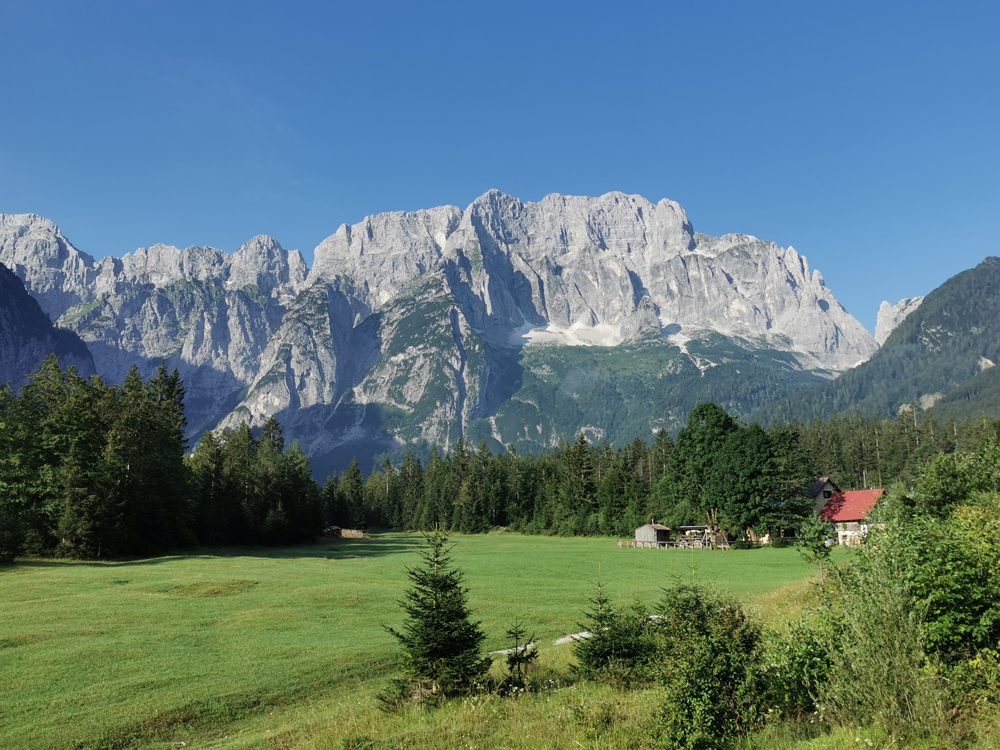


No comments:
Post a Comment