For a work trip, I had to head to the northern French city of Caen where I spent a few days before then doing a weekend trip around Normandy with some of my coworkers. After leaving Venice Airport early on the 15th, we reached Paris and from there took a train taking us to Caen. The event ran over three days, and we managed to have very little free time. However, in the spare moments I had, I decided to quickly visit the city center. As our work was taking place in the beautiful settings of the Abbey of Sainte-Trinité, also known as Abbaye aux Dames, home to the regional council of Normandy, I decided to visit the church first. It was founded in the 11th century by William the Conqueror and his wife Matilda of Flanders as a benedictine monastery for nuns, thus the name "aux dames" the "hommes" one for men being on the opposite side of town. Construction started in 1062 from the apse, as all churches were constructed this way, and was completed around 1130. It features a gothic structure with a tall facade flanked by towers, whose original spires were destroyed in the Hundred Years' War. Of note was the crypt below the main altar with columns topped with impressive capitals depicting all kinds of figures. Next to the altar, on the choir's floor, is the black marble slab where queen Matilda was buried. After heading out and towards the city, I then passed by the Collegiate church of the Holy Sepulchre, built during the 13th century but with later additions. It was unfortunately closed so that meant continuing on and reaching than the impressive structure of the castle. The Chateau was originally built around 1060 by William the Conqueror and his son Henry I continued the work by adding a keep, a hall for the ducal court, and the church of St John, now the info point and ticket office for the local museums. The keep was torn down during the french revolution, and the whole complex was heavily bombed during world war 2, nevertheless, it is still well preserved and its massive walls are a sight to marvel at. I entered through the eastern gate, the Porte des Champs and walked across the large open space reaching the edge of the western walls from where I had an excellent view over the city. Then I headed up the southern walls and gazed to another part of the center. Two museums had been set in some buildings specifically made, the Musee de Normandie and the Musee des Beaux-Arts. There was no time to visit them so instead, I decided to exit the chateau and walked through the old town. The small neighborhood just east of the castle is the oldest part of the city and the best preserved. It holds some beautiful houses, some of which with the typical timber-framed structure. As I walked through I admired the lovely streets and nice cafès which, with hotter weather, would be a welcome stopping point.
After the three intensive days in Caen, we decided to rent two cars and left in the morning of the 18th to reach the infamous Omaha Beach, a stretch of sand between the towns of Sainte-Honorine-des-Pertes and Vierville-Sur-Mer. This place was the location of one of five sectors of the Allied invasion of German-occupied France that occurred on June 6, 1944, and the code name Omaha was given to it. After reaching the waterfront, we parked the car and continued on foot. Right off the main road, on an opening, stands a monument to the allied invasion in this area and particularly to the 1st US infantry division which suffered the most casualties. Right in front of it, on the shore, is a memorial called Les Braves consisting of stainless steel columns depicting three elements: Wings of Hope, Rise Freedom and the Wings of Fraternity. After walking along the shore, we got back in the car and drove a little further to reach the Normandy American Cemetery and Memorial. We parked and entered the grounds on foot. The park is really large and features a long avenue sided by trees with all the tombstones lined around it. 9388 people are buried there each one signaled by a white cross or Jewish star, due to the army's diverse composition. A memorial close to the entrance includes maps and details of the Normandy landings and military operations which followed. In the same area, a semi-circular garden was built with engravings to commemorate 1557 service members who were declared missing in action (either lost at sea or dead with the sinking of the SS Leopoldville). After a moment of recollection in that sacred ground, we decided to head further and downhill to the nearby beach. As we descended, we passed by some grazing cows and the remains of the defensive system set up for D-day. There were dug up trenches, bunkers, battlements, and cannon positions. After reaching the seashore we explored around and then decided to head back uphill to the car and continue our trip. After a bit of driving through peaceful countryside and a few farms selling typical local cider, we reached our next stop: Pointe du Hoc. After reaching the parking lot, we left out the car and continued on foot. Following a path, we reached the first artillery bunkers overlooking the English Channel. The Pointe du Hoc is, in fact, a promontory hill jutting out to the sea and at the time of world war II was the highest point between Utah Beach to the west and Omaha Beach to the east, making it thus a valuable strategic location. The relatively small area was dotted with remains of casemates and artillery pits and was also covered in what seemed to be bomb holes from the war. As before in Omaha beach, it was mesmerizing yet eerie to stand in a place so iconic during the Normandy landings where many had lost their lives on both sides. After exploring the bunkers and walking around we headed back to the car and continued on our trip, reaching then our next stop about 2h of driving later. Mont St Michel, the famous tidal island topped by its impressive castle/abbey, was easily visible in the distance across the flat tidal lands. I had long dreamed and hope to be able to see the site, so being there at that moment was a great joy for me. In order to reach the island, a new causeway had been built but could only be reached by bus or on foot. We then parked the car in the dedicated car spaces to the south and decided to make the commute on the bus and reach the island. After getting off we were in close sight of the impressive rock with the splendid gothic structures jutting out on top of it. We entered the small historic part by passing through the southern gate and walking along the very crowded main street, Grande Rue. We decided to head up first and reach the Abbey in order to see it before the closing time. We took minor side streets leading upwards and quickly reached the entrance to the complex. After buying the tickets, we headed inside the Abbey and explored its many rooms spread throughout several levels. Originally known as Monte Tombe, it was believed that the rock had been inhabited since Roman times and well through the Frank invasions. A legend tells that the Archangel Michael appeared in 708 to the bishop of Avranches, Aubert, instructing him to build a church on top of the island rock. Thus the change in the name into Mont St Michel au peril de la Mer (Mount Saint Michael at the peril of the sea). From then on the Abbey witnessed borderline changes and different patrons. Benedictine monks took up residence and established their order over the abbey, turning it into a thriving complex. The notorious Italian architect Guglielmo da Volpiano was chosen by Richard II of Normandy to build the church of the Abbey on the highest spot of the rock in 1060. The Abbey reached its apex during the 12th century, particularly during the time of the abbot of Torigni when the structure was further developed. Its importance waned throughout its subsequent existence as it also became a state jail under the reign of Louis XI; the abbey was then finally closed in 1791, during the French Revolution, and fully turned into a prison (its position and structure made it very suitable for such an end). The prison was then closed in 1863, under the pressure of influential figures such as Victor Hugo, and the abbey restored. After becoming a national historical monument in 1874 it was then inscribed in the Unesco world heritage site list in 1979. So our visit began by reaching the highest spot of the rock, from where we had an amazing view of the structures and town below and the surrounding tidal landscape. Up there we then entered the Abbey church proper, featuring an 18th-century facade that had been rebuilt after a fire destroyed the original one. Once inside, I marveled at the elegant simplicity of its original Romanesque structure.The choir had been reconstructed in flamboyant gothic style at the end of the 15th century after the original romanesque had collapsed. Next to the church proper is a three-story building known as the Merveille, built in gothic style during the 13th century. It was the monk living area and features several structures. Through a door in the northern nave of the church, I reached the cloister first, a beautiful courtyard featuring a mix of romanesque and gothic styles. A door then led to the refectory where the monks used to have their meals. From there, descending down a staircase, I reached the Salle des Chevaliers (Knights' room), one of the nicest in the whole complex featuring beautiful gothic arcades. Then several smaller rooms included chapels, rooms and other service quarters. One part even featured a large treadwheel crane which was used during the abbey's time as a prison to haul in needed supplies. After seeing the whole complex I then went out and got back together with the rest of the group. From there we descended a series of steps on the northern side and reached the structures of the town. It was incredible to notice how just a couple of hours before the surrounding tidal land was completely dry and we could not even spot the sea in the distance while now the tide had quickly swept in reaching the rock and surrounding it. We walked on top of the eastern walls that had for centuries defended the town that had grown at the foot of the abbey, from there we were granted a view over the rooftops on one side and the now completely water-covered tidal landscape on the other. The streets were now nearly empty as most of the daytrippers had left before the waters came. We walked around a bit finally having the place mostly to ourselves and then decided to head back to the cars ourselves. We found out though that the gate we had come in through was now flooded and tried to figure out a way to exit without getting wet. I proceeded to take my shoes off in fear of having to wait there for several hours before the tide decided to change its course. Luckily though, in recent years, a secondary entrance had been made where the man-made causeway was built as they had specifically arranged it in case of the common high tides which hit the area. This way we were able to exit the complex with dry feet. After reaching our cars glad to have visited such an incredible monument we then drove a few minutes south until we reached the town of Pontorson where we had booked a place to sleep at the hotel Le XIV. After checking in we left our luggage and then headed out into town to find a place to eat dinner. We found a place called Le Grillon where we tried the local specialty: Galettes, a Norman and Breton type of crepe made with buckwheat. After a tasty dinner, it was time for us to head back to our accommodation and sleep. The next day, our last day on the trip, we woke up early in order to drive all the way back to Caen and hand back our rental cars. Then getting on a train we switched in Rouen and reached the town of Vernon in the early afternoon. We had decided to come here as most of the group components wanted to see Monet's garden and home in the nearby town of Giverny. However, as Adrian, the Czech guy, and I didn't wish to head there, we decided to stay in Vernon instead. Two of the other girls also stayed with us as they had booked an earlier flight from Paris and wouldn't have managed to see Giverny in time. We decided to have lunch at the café right in front of the station where we had a really tasty North African couscous with cooked vegetables. After that, the girls left to take their train while Adrian and I asked the owner if we could leave everyone's luggage there while we headed out to explore the town. We set to explore the center on foot, heading first across the river Seine to reach the other side where a beautiful and interesting building was set. A timber-framed mill was, in fact, standing on a stone arch which was once part of a bridge spanning the river. Only five pillars are all that remain of that bridge providing interesting photo opportunities. Right behind the mill stands also a nice medieval castle called Chateau de Tourelles featuring fortified towers and built at the end of the 12th century to guard the passage along the river. Giverny was set on the same side of the river as we were now, but that meant a long bit of walking so instead we decided to head back across and into Vernon itself. We reached the Collegiale Notre Dame, a nice gothic church serving as the main religious edifice of the town. The interior was light and airy and featured some beautiful details. Once outside, we face the neoclassical town hall built at the end of the 19th century and to the right a pretty street filled with timber-framed houses which we decided to walk along. Reaching the northwestern end of town we came across a medieval round tower known as the Tour des Archives originally built in 1123 by Henry I of England, son of William the Conqueror, and then replaced by a similar structure by Philip II of France.
 |
| The Abbaye aux Dames |
 |
| Interior of the church |
 |
| The walls of the Chateau |
 |
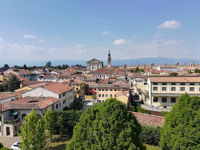
| View from the top of the walls |
 |
| One of the lovely streets of the old town |
 |
| Another old town street |
 |
| The complex of the Abbaye aux Dames |
 |
| One of the cloisters of the Abbey, now site of the Regional government |
 |
| Omaha Beach |
 |
| The Normandy American Cemetery and Memorial |
 |
| The bunkers overlooking Omaha Beach |
 |
| View of Pointe du Hoc |
 |
| The Mt St Michel |
 |
| View from the monastery of the surrounding tidal flats |
 |
| The cloister of the monastery |
 |
| The refectory |
 |
| The Knights' Room |
 |
| View of the walls and the rising tide |
 |
| The Mt St Michel in the distance |
 |
| The timber frame mill in Vernon |
 |
| The Chateu des Tourelles |
 |
| View of the Collegiale de Notre Dame from the back |
 |
| The Collegiale and timber frame buildings |
 |
| The Tour des Archives |


